Snaresbrook: Difference between revisions
mNo edit summary |
|||
| Line 22: | Line 22: | ||
==Transport== | ==Transport== | ||
The nearest [[London Underground]] station is Snaresbrook | The nearest [[London Underground]] station is Snaresbrook on the [[Epping, Essex|Epping]] branch of the Central line. | ||
[[Category:Metropolitan Essex]] | [[Category:Metropolitan Essex]] | ||
Latest revision as of 12:44, 9 October 2019
| Snaresbrook | |
| Essex | |
|---|---|
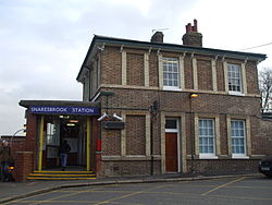
 Snaresbrook tube station | |
| Location | |
| Grid reference: | TQ395895 |
| Location: | 51°35’13"N, -0°-0’52"E |
| Data | |
| Post town: | London |
| Postcode: | E11 |
| Dialling code: | 020 |
| Local Government | |
| Council: | Redbridge / Waltham Forest |
| Parliamentary constituency: |
Leyton and Wanstead |
Snaresbrook is a suburban village in south-western Essex, within the greater London conurbation. It is contiguous with Walthamstow to the west, Woodford to the north, Redbridge to the east and Wanstead and Leytonstone to the south.
The name derives from a corruption of Sayers brook, a tributary of the River Roding that flows through Wanstead to the east.
Snaresbrook is bounded approximately by South Woodford to the north, the lower reaches of Epping Forest and Upper Leytonstone and Walthamstow to the west, Leytonstone to the south and Wanstead to the east.
Snaresbrook's most notable building is Snaresbrook Crown Court. It was opened in 1843 as an Infant Orphan Asylum by King Leopold I of Belgium, and later became the Royal Wanstead School. It was designed by Sir George Gilbert Scott and William Bonython Moffatt.
Transport
The nearest London Underground station is Snaresbrook on the Epping branch of the Central line.