A' Ghlas-bheinn: Difference between revisions
Created page with '{{Infobox hill |name=A' Ghlas-bheinn |county=Ross-shire |range=Kintail |SMC=11 |picture=A' Ghlas-bheinn (918m) - geograph.org.uk - 123674.jpg |picture caption= |height=3,012 feet…' |
No edit summary |
||
| Line 7: | Line 7: | ||
|picture caption= | |picture caption= | ||
|height=3,012 feet | |height=3,012 feet | ||
| | |latitude=57.255057 | ||
|longitude=-5.304039 | |||
|os grid ref=NH008231 | |os grid ref=NH008231 | ||
}} | }} | ||
| Line 14: | Line 15: | ||
A’ Ghlas-bheinn is the most westerly Munro in this region and though many of the mountains in this region are remote, this is more accessible, as the A87 at Loch Duich is close by, the mountain standing over the road. | A’ Ghlas-bheinn is the most westerly Munro in this region and though many of the mountains in this region are remote, this is more accessible, as the A87 at Loch Duich is close by, the mountain standing over the road. | ||
The summit of A’ Ghlas-bheinn is rough, marked with crags and steeps drops to all sides; a great deal of character on such a small Munro. The summit is where three ridges meet: the southern ridge leads to a high col before becoming the | The summit of A’ Ghlas-bheinn is rough, marked with crags and steeps drops to all sides; a great deal of character on such a small Munro. The summit is where three ridges meet: the southern ridge leads to a high col before becoming the north-west ridge of its much larger neighbour, [[Beinn Fhada]]. The two are normally climbed together. The northern ridge leads to subsidiary peaks, Creag na Saobhie and Meall Dubh. The western ridge leads down to Dorusduam and easy tracks out to the A87. | ||
All these ridges are steep and craggy require scrambling. | All these ridges are steep and craggy require scrambling. | ||
Latest revision as of 19:01, 27 August 2018
| A' Ghlas-bheinn | |||
| Ross-shire | |||
|---|---|---|---|

| |||
| Range: | Kintail | ||
| Summit: | 3,012 feet NH008231 57°15’18"N, 5°18’15"W | ||
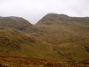
A' Ghlas-bheinn is a mountain in Ross-shire, which reaches a height of 3,012 feet at its summit, and so it qualifies as a Munro.
A’ Ghlas-bheinn is the most westerly Munro in this region and though many of the mountains in this region are remote, this is more accessible, as the A87 at Loch Duich is close by, the mountain standing over the road.
The summit of A’ Ghlas-bheinn is rough, marked with crags and steeps drops to all sides; a great deal of character on such a small Munro. The summit is where three ridges meet: the southern ridge leads to a high col before becoming the north-west ridge of its much larger neighbour, Beinn Fhada. The two are normally climbed together. The northern ridge leads to subsidiary peaks, Creag na Saobhie and Meall Dubh. The western ridge leads down to Dorusduam and easy tracks out to the A87.
All these ridges are steep and craggy require scrambling.
The summit affords wonderful views of Beinn Fhada and its impressive array of corries.
| Munros in SMC Area SMC Section 11 - Glen Affric and Kintail |
|---|
|
A' Chràlaig • A' Ghlas-bheinn • An Socach • Aonach Meadhoin • Beinn Fhionnlaidh • Ben Attow • Carn Eige • Carn Ghluasaid • Ciste Dhubh • Mam Sodhail • Mullach Fraoch-choire • Mullach na Dheiragain • Sail Chaorainn • Saileag • Sgùrr a' Bhealaich Dheirg • Sgùrr Fhuaran • Sgùrr na Càrnach • Sgùrr na Ciste Duibhe • Sgùrr nan Ceathramhnan • Sgùrr nan Conbhairean • Toll Creagach • Tom a' Choinich |