Pool of Muckhart: Difference between revisions
No edit summary |
No edit summary |
||
| Line 19: | Line 19: | ||
The name of the village is from that of its parish [[Muckhart]], which comes from the Gaelic ''Muc-àird'', in turn from 'muc' (Pig) + 'àird' (Height). | The name of the village is from that of its parish [[Muckhart]], which comes from the Gaelic ''Muc-àird'', in turn from 'muc' (Pig) + 'àird' (Height). | ||
Nearby runs the old coaching road to Dollar along the line of the Hillfoots; the road is now just a dirt track (locally known as the Cinder Path), and leads to the parish | Nearby runs the old coaching road to Dollar along the line of the Hillfoots; the road is now just a dirt track (locally known as the Cinder Path), and leads to the parish school, built when the road was a road. West of the school the old coach route is very hard to follow. | ||
The parish school is inconveniently west of the village, not from careful planning but from the requirements of bureaucracy; the 1876 Act required that each school be at the centre of the parish, but the Muckhart parish boundary extends to the outer edge of [[Dollar]], some three miles west, and so the school is over half a mile west of the outer edge of the village. The school is also some considerable distance from the main road, on the old coach road. | The parish school is inconveniently west of the village, not from careful planning but from the requirements of bureaucracy; the 1876 Act required that each school be at the centre of the parish, but the Muckhart parish boundary extends to the outer edge of [[Dollar]], some three miles west, and so the school is over half a mile west of the outer edge of the village. The school is also some considerable distance from the main road, on the old coach road. | ||
The famed, historic [[Rumbling Bridge]] across Rumbling Bridge Gorge of the [[River Devon, Clackmannanshire | River Devon]] in [[Kinross]] is about 300 | The famed, historic [[Rumbling Bridge]] across Rumbling Bridge Gorge of the [[River Devon, Clackmannanshire | River Devon]] in [[Kinross]] is about 300 yards south of the Muckhart Golf Course on the A823. | ||
==The village== | ==The village== | ||
Revision as of 20:32, 3 November 2016
| Pool of Muckhart | |
| Perthshire | |
|---|---|
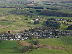
 Pool of Muckhart from Seamab | |
| Location | |
| Grid reference: | NO001007 |
| Location: | 56°11’18"N, 3°36’41"W |
| Data | |
| Post town: | Dollar |
| Postcode: | FK14 |
| Dialling code: | 01259 |
| Local Government | |
| Council: | Clackmannanshire |
| Parliamentary constituency: |
Ochil and South Perthshire |
Pool of Muckhart is a village in southern Perthshire. It is one of the Hillfoots Villages, sitting at the foot of the long, scarp slope of the Ochil Hills. The village is on the A91 around three miles north-east of Dollar in Clackmannanshire.
The name of the village is from that of its parish Muckhart, which comes from the Gaelic Muc-àird, in turn from 'muc' (Pig) + 'àird' (Height).
Nearby runs the old coaching road to Dollar along the line of the Hillfoots; the road is now just a dirt track (locally known as the Cinder Path), and leads to the parish school, built when the road was a road. West of the school the old coach route is very hard to follow.
The parish school is inconveniently west of the village, not from careful planning but from the requirements of bureaucracy; the 1876 Act required that each school be at the centre of the parish, but the Muckhart parish boundary extends to the outer edge of Dollar, some three miles west, and so the school is over half a mile west of the outer edge of the village. The school is also some considerable distance from the main road, on the old coach road.
The famed, historic Rumbling Bridge across Rumbling Bridge Gorge of the River Devon in Kinross is about 300 yards south of the Muckhart Golf Course on the A823.
The village

Pool of Muckhart stands slightly east of the centre of the parish, in the valley of the River Devon, near the entrance to Glen Devon.
The village lies at the eastern end of the "Hillfoots Villages" which skirt the southern edge of the Ochil Hills; the last in the range, standing as a backdrop to the village to its north side is Seamab.
Of note in the village is the Muckhart Inn,[1] an early 18th-century coaching inn, lying at the point where the old coach road and modern road unite. Whilst the building was always low, this effect has been emphasised due to the raising of the road level (normal when ancient routes were macadamed in the early 19th century).
The war memorial,[2] on the western edge of the village by the main road, is by local sculptor George Henry Paulin.
Parish church

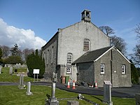
The parish church[3] also dates from the 18th century but is a plain Scots box chapel in style. In the churchyard is the family monument to the Christies of Cowden (a large estate one mile west, see below).[4] This estate was famed for its Japanese garden which has now returned to nature, having been abandoned c.1960. Its Japanese gardener, Mat Su, is buried at the end of the Christie lair.
Muckhart Golf Club
Muckhart Golf Club[5] lies on the School Road (Drumbum Road) south of the village. Set on a series of low rocky hills it includes several challenging holes. There are three nine-hole courses, named Arndean, Cowden, and Naemoor. The nine-hole Cowden course was opened by Miss Ella Christie, who provided 55 acres of land, on 28 May 1908. The course fell into disrepair during Second World War, when it was used for the grazing of sheep. The course was restored after the war. A second nine-hole course, the Ardean course was added in the late 1960s on land leased from Colonel (later Sir) Robert Christie Stewart,[6] then Lord-Lieutenant of the county. A third nine-hole course named Naemoor was opened on 25 July 1998.
See also
Outside links
| ("Wikimedia Commons" has material about Muckhart) |
References
Books
- Christie, Ella R. Khiva to Samarkand. Coventry: Trotamundas Press, Ltd., 2009 ISBN 978-1-906393-17-5 (Reprint of Christie, Ella. Through Khiva to Golden Samarkand. London: Seeley, Service & Co. Ltd., 1925)
- Christie, Ella R. & Stewart, Alice Margaret Christie King. A Long Look at Life, by Two Victorians. London: Seeley, Service & Co. Ltd., 1940.
- Stewart, Averil. Alicella. London: John Murray, 1955.
- Birkett, Dea. Spinsters Abroad: Victorian Lady Explorers. New York: Dorset Press, 2001. ISBN 0-7607-1932-2.
- Day, John Percival. Clackmannan and Kinross. Nabu Press, 2010 ( Reproduction of a book published before 1925).
- Barbieri, M. A Descriptive and Historical Gazetteer of the Counties of Fife, Kinross and Clackmannan: With Anecdotes, Narratives and Graphic Sketches, Moral, Political, Commercial and Agricultural. Nabu Press, 2010.
| The Hillfoots Villages of Stirlingshire, Clackmannanshire and Perthshire |
|---|
|
Blairlogie • Menstrie • Alva • Tillicoultry • Dollar • Pool of Muckhart |
