Exeter: Difference between revisions
No edit summary |
m clean up, typos fixed: present day → present-day, As a result → As a result, (2), However → However, , three month → three-month |
||
| Line 54: | Line 54: | ||
==The Middle Ages== | ==The Middle Ages== | ||
In 1136, early in the Anarchy, Rougemont Castle was held against King Stephen by Baldwin de Redvers. Baldwin submitted only after a three month siege, not when the three wells in the castle ran dry, but only once the large supplies of wine in the garrison that they were using for drinking, baking, cooking and for putting out the fires started by the besiegers, were exhausted.<ref>Hoskins 2004, pp.31–32</ref> | In 1136, early in the Anarchy, Rougemont Castle was held against King Stephen by Baldwin de Redvers. Baldwin submitted only after a three-month siege, not when the three wells in the castle ran dry, but only once the large supplies of wine in the garrison that they were using for drinking, baking, cooking and for putting out the fires started by the besiegers, were exhausted.<ref>Hoskins 2004, pp.31–32</ref> | ||
The city held a weekly market for the benefit of its citizens from at least 1213, and by 1281 Exeter was the only town in the south west to have three market days a week. There are also records of seven annual fairs, the earliest of which dates from 1130, and all of which continued until at least the early 16th century.<ref>{{cite web | The city held a weekly market for the benefit of its citizens from at least 1213, and by 1281 Exeter was the only town in the south west to have three market days a week. There are also records of seven annual fairs, the earliest of which dates from 1130, and all of which continued until at least the early 16th century.<ref>{{cite web | ||
| Line 78: | Line 78: | ||
===Georgian and Victorian periods=== | ===Georgian and Victorian periods=== | ||
[[File:High Street, Exeter, England, ca. 1895.jpg|thumb|right|The High Street ~1895]] | [[File:High Street, Exeter, England, ca. 1895.jpg|thumb|right|The High Street ~1895]] | ||
Early in the Industrial Revolution, Exeter's industry developed on the basis of locally available agricultural products and, since the city's location on a fast-flowing river gave it ready access to water power, an early industrial site developed on drained marshland to the west of the city, at Exe Island. However when steam power replaced water in the 19th century, Exeter was too far from sources of coal (or iron) to develop further. As a result the city declined in relative importance, and was spared the rapid 19th century development that changed many historic European cities. Extensive canal redevelopments during this period further expanded Exeter's economy, with "vessels of 15 to 16 tons burthen [bringing] up goods and merchandise from [[Topsham]] to the City Quay".<ref>{{cite book|last=Oliver|first=George|title=History of the City of Exeter|year=1861|pages=107}}</ref> | Early in the Industrial Revolution, Exeter's industry developed on the basis of locally available agricultural products and, since the city's location on a fast-flowing river gave it ready access to water power, an early industrial site developed on drained marshland to the west of the city, at Exe Island. However, when steam power replaced water in the 19th century, Exeter was too far from sources of coal (or iron) to develop further. As a result, the city declined in relative importance, and was spared the rapid 19th century development that changed many historic European cities. Extensive canal redevelopments during this period further expanded Exeter's economy, with "vessels of 15 to 16 tons burthen [bringing] up goods and merchandise from [[Topsham]] to the City Quay".<ref>{{cite book|last=Oliver|first=George|title=History of the City of Exeter|year=1861|pages=107}}</ref> | ||
The first railway to arrive in Exeter was the Bristol and Exeter Railway, with St Davids Station. The South Devon Railway Company extended the line westwards to [[Plymouth]], opening their own smaller station at Exeter St Thomas, near the lower end of Fore Street. A more central railway station, that at Queen Street Station (now Exeter Central), was opened by the London and South Western Railway in 1860. | The first railway to arrive in Exeter was the Bristol and Exeter Railway, with St Davids Station. The South Devon Railway Company extended the line westwards to [[Plymouth]], opening their own smaller station at Exeter St Thomas, near the lower end of Fore Street. A more central railway station, that at Queen Street Station (now Exeter Central), was opened by the London and South Western Railway in 1860. | ||
| Line 90: | Line 90: | ||
Despite some local opposition,<ref>{{cite web|url = http://news.bbc.co.uk/1/hi/england/2817257.stm|title = High Street revamp plans criticised|accessdate = 2007-09-21|publisher = BBC News | date=2003-03-04}}</ref> the Princesshay shopping centre has been redeveloped between the Cathedral Close and the High Street. The development was completed and opened on time on 20 September 2007.<ref>{{cite web|url = http://www.bbc.co.uk/devon/content/articles/2007/09/19/princesshay_opening_day_feature.shtml|title = Doors open at Princesshay|accessdate = 2007-09-21|date = 2007-09-20|publisher = BBC Devon}}</ref><ref>{{cite news| title = Heaven for shoppers as Princesshay gets off to a flying start with huge crowds for opening day| url = http://www.thisisexeter.co.uk/displayNode.jsp?nodeId=142326&command=displayContent&sourceNode=142321&contentPK=18452155&folderPk=79876&pNodeId=142331| publisher = Express & Echo| date = 2007-09-21| accessdate = 2007-09-21}}</ref> There are 123 varied residential units incorporated into the new Princesshay.<ref>{{cite web|url = http://www.princesshay.com/community/Keyfacts/index.aspx|title = Key facts about Princesshay|accessdate = 2007-09-21|work = Princesshay.com|publisher = Land Securities Group}}</ref> | Despite some local opposition,<ref>{{cite web|url = http://news.bbc.co.uk/1/hi/england/2817257.stm|title = High Street revamp plans criticised|accessdate = 2007-09-21|publisher = BBC News | date=2003-03-04}}</ref> the Princesshay shopping centre has been redeveloped between the Cathedral Close and the High Street. The development was completed and opened on time on 20 September 2007.<ref>{{cite web|url = http://www.bbc.co.uk/devon/content/articles/2007/09/19/princesshay_opening_day_feature.shtml|title = Doors open at Princesshay|accessdate = 2007-09-21|date = 2007-09-20|publisher = BBC Devon}}</ref><ref>{{cite news| title = Heaven for shoppers as Princesshay gets off to a flying start with huge crowds for opening day| url = http://www.thisisexeter.co.uk/displayNode.jsp?nodeId=142326&command=displayContent&sourceNode=142321&contentPK=18452155&folderPk=79876&pNodeId=142331| publisher = Express & Echo| date = 2007-09-21| accessdate = 2007-09-21}}</ref> There are 123 varied residential units incorporated into the new Princesshay.<ref>{{cite web|url = http://www.princesshay.com/community/Keyfacts/index.aspx|title = Key facts about Princesshay|accessdate = 2007-09-21|work = Princesshay.com|publisher = Land Securities Group}}</ref> | ||
Previously regarded as second only to [[Bath, Somerset|Bath]] as an architectural site in southern England, since the 1942 bombing and subsequent reconstruction Exeter has been a city with some beautiful buildings rather than a beautiful city. As a result Exeter is not dominated by tourism. | Previously regarded as second only to [[Bath, Somerset|Bath]] as an architectural site in southern England, since the 1942 bombing and subsequent reconstruction Exeter has been a city with some beautiful buildings rather than a beautiful city. As a result, Exeter is not dominated by tourism. | ||
==Churches== | ==Churches== | ||
| Line 129: | Line 129: | ||
* The '''Guild of Tuckers and Weavers''', a fine old building that is still used for smart functions. | * The '''Guild of Tuckers and Weavers''', a fine old building that is still used for smart functions. | ||
* The '''Custom House''' in the attractive Quay area, which is the oldest brick building surviving in the city. | * The '''Custom House''' in the attractive Quay area, which is the oldest brick building surviving in the city. | ||
* "The House That Moved", a 14th-century Tudor building, earned its name in 1961 when it was moved from its original location on the corner of Edmund Street in order for a new road to be built in its place. Weighing more than twenty-one tonnes, it was strapped together and slowly moved a few inches at a time to its present day position. | * "The House That Moved", a 14th-century Tudor building, earned its name in 1961 when it was moved from its original location on the corner of Edmund Street in order for a new road to be built in its place. Weighing more than twenty-one tonnes, it was strapped together and slowly moved a few inches at a time to its present-day position. | ||
*'''Parliament Street''' in the city centre is the narrowest street in the United Kingdom. | *'''Parliament Street''' in the city centre is the narrowest street in the United Kingdom. | ||
*The '''Butts Ferry''', an ancient cable ferry across the River Exe. | *The '''Butts Ferry''', an ancient cable ferry across the River Exe. | ||
Revision as of 14:24, 27 January 2016
| Exeter | |
| Devon | |
|---|---|
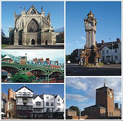 Exeter scenes | |
| Location | |
| Location: | 50°46’20"N, 3°32’1"W |
| Data | |
| Population: | 118,800 (2009 est) |
| Dialling code: | 01392 |
| Local Government | |
| Council: | Exeter |
| Parliamentary constituency: |
Exeter |
The City of Exeter is the county town of Devon and the site of Exeter Cathedral, founded in the 12th century and the seat of the Diocese of Exeter. It is a city full of history and, despite suffering in the Blitz and the later redevelopment, it retains a wealth of historic buildings from many of its ages.
Exeter stands on the River Exe, 9 miles from the sea and was formerly a seaport. It remains the chief town of East Devon and a major regional centre.
The city centre and its historic heart is on the eastern bank of the Exe on a ridge of land which forms the backbone of the city backed by a steep hill where the Exe, joined by the River Creedy, opens onto a wide flood plain and estuary. The Cathedral atop the ridge is visible for many miles around.
Historically this was the lowest bridging point of the River Exe and the Exe was tidal and navigable up to the city until the construction of weirs later in its history. This combined with the easily defensible higher ground of the ridge made the current location of the city a natural choice for settlement and trade. In George Oliver's The History of the City of Exeter, it is noted that the most likely reasons for the original settling of what would become modern Exeter was the "fertility of the surrounding countryside" and the area's "beautiful and commanding elevation [and] its rapid and navigable river".[1]
Rougemont Castle stands on hill formed by a volcanic plug in the city centre.
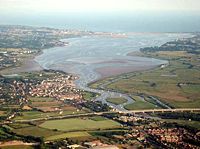
Exeter was the most south-westerly Roman fortified settlement in Britain as Isca Dumnoniorum and has been an inhabited town uninterruptedly since those days, its name developing through Isca (Latin), Caerwysg (British), Escanceaster(876), Exanceaster (877 and later), Excester (1563) and finally "Exeter".
Exeter has been identified as one of the top ten most profitable locations for a business to be based.[2] The city has good transport links, with two railway stations, the M5 motorway and Exeter International Airport connecting the city both nationally and internationally. Although a popular tourist destination, the city is not dominated by tourism.
History
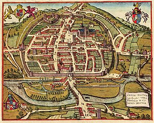
Early Exeter
The discovery of coins dating from the Hellenistic period in the city indicates the existence of a settlement that was trading with the Mediterranean region as early as 250 BC.[3]
The Latin name for Exeter, Isca Dumnoniorum ("Isca of the Dumnones or Devonians"), suggests that the city was of Celtic origin, predating the Roman city founded in about 50 AD. Isca is derived from a Brythonic Celtic word for flowing water, found also in the names of the River Usk in Monmouthshire and many rivers named "Esk". The name Isca Dumnoniorum distinguished the town from Isca Silurium (later Isca Augusta); modern Caerleon.
Significant parts of the Roman wall remain, though most of the visible structure is later. Most of its route can be traced on foot. A substantial Roman bath complex was excavated in the 1970s,[4][5] but because of its proximity to the cathedral, it was not practical to retain the excavation for public view.
Exeter was the southern starting point for the Fosse Way, a Roman road. More than 1,000 Roman coins have been found in the city indicating its importance as a trading centre. The dates of these coins suggest that the city was at its most prosperous in the first half of the fourth century. However, virtually no coins dated after AD 380 have been found, suggesting a rapid decline.[6]
After the Romans left Britain in the early 5th century nothing is known of Exeter for about 270 years, until around 680 when a document about St Boniface reports that he was educated at the Abbey in Exeter.[7]
The early mediæval period
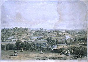
It is believed that the English inhabitation of Exeter began at some time after King Cenwalh of the West Saxons defeated the Britons at the Battle of "Peonnum" in Somerset in 658,[8] which opened up the British Kingdom of Dyfnaint. According to a much later Chronicler, William of Malmesbury, a distinct part of the city was retained by the Britons until 928.
In 876 Exeter was attacked and captured by the Danes. Alfred the Great drove them out the next summer,[9] and in the following years made Exeter a new burh, one of four in Devon, repairing the Roman city walls in the process.[10] In 893 the city held off another siege by the Danes.[10]
In about 928 King Athelstan had the walls thoroughly repaired and according to William of Malmesbury he then drove the Welsh (Britons) out from the city,[9] rather uncharacteristic of Athelstan, a king known for his partiality to the Welsh. No more is known of this incident. According to William of Malmesbury, the Britons were sent beyond the River Tamar, thereby fixing that river as the boundary of Devonshire.[11] The quarter vacated by the Britons was then apparently adapted as "the earl's burh", and was still named Irlesberi in the 12th century.[9]
In 1001 the Danes again failed to get into the city, but they were able to plunder it in 1003 because they were let in by the French reeve of Emma of Normandy, who had been given the city as part of her dowry on her marriage to King Ethelred II the previous year.[9]
In 1066 William the Bastard took the throne, and in 1067 Exeter (residence of the slain King Harold's mother, Gyþa Þorkelsdóttir) rebelled against King William. William marched west and laid siege. After 18 days William accepted the city's honourable surrender in which he swore an oath not to harm the city nor increase its ancient tribute. However, William quickly arranged for the building of Rougemont Castle to ensure the city's compliance in future. Properties owned by English landlords were transferred into Norman hands, and on the death of Bishop Leofric in 1072, the Norman Osbern FitzOsbern was appointed his successor.[12]
The Middle Ages
In 1136, early in the Anarchy, Rougemont Castle was held against King Stephen by Baldwin de Redvers. Baldwin submitted only after a three-month siege, not when the three wells in the castle ran dry, but only once the large supplies of wine in the garrison that they were using for drinking, baking, cooking and for putting out the fires started by the besiegers, were exhausted.[13]
The city held a weekly market for the benefit of its citizens from at least 1213, and by 1281 Exeter was the only town in the south west to have three market days a week. There are also records of seven annual fairs, the earliest of which dates from 1130, and all of which continued until at least the early 16th century.[14]
In 1286 Isabella de Fortibus, Countess of Devon, had a weir constructed across the Exe below the city, Countess Weir, which prevented ships from reaching Exeter and cut its trade off until a channel was opened. In 1317 Hugh de Courtenay, 9th Earl of Devon built another weir which forced ships to unload at his new quay at Topsham. Trade with the sea was not restored until the Exeter Canal opened in 1566.
Tudor and Stuart Exeter
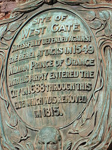
In 1549 the city successfully withstood a month-long siege by the Prayer Book rebels. The Livery Dole Almshouses and Chapel at Heavitree were founded in March 1591 and finished in 1594. They can still be seen today in the street which bears the name Livery Dole.
The city's motto, Semper fidelis, is traditionally held to have been suggested by Elizabeth I, in acknowledgement of the city's contribution of ships to help defeat the Spanish Armada in 1588;[15] however its first documented use is in 1660.
Exeter was at first a Parliamentary town in the English Civil War in the largely Royalist South West, but it was captured by the Royalists on 4 September 1643, and it remained in their control until near the end of the war, being one of the final Royalist cities to fall into Parliamentary hands. During this period, Exeter was an economically powerful city, with a strong trade of wool. This was partly due to the surrounding area which was "more fertile and better inhabited than that passed over the preceding day" according to Count Lorenzo Magalotti who visited the city when he was 26 years old.[16] Magalotti writes of over thirty thousand people being employed in the county of Devon as part of the wool and cloth industries, merchandise that was sold to "the West Indies, Spain, France and Italy".[17] Celia Fiennes also visited Exeter during this period, in the early 1700s. She remarked on the "vast trade" and "incredible quantity" in Exeter, recording that "it turns the most money in a week of anything in England", between £10,000—£15,000.[18]
In 1677 the Exeter Canal was extended and the entrance was moved downstream to Topsham. In 1701 it was widened to allow ocean-going ships to reach the city.
Georgian and Victorian periods
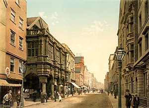
Early in the Industrial Revolution, Exeter's industry developed on the basis of locally available agricultural products and, since the city's location on a fast-flowing river gave it ready access to water power, an early industrial site developed on drained marshland to the west of the city, at Exe Island. However, when steam power replaced water in the 19th century, Exeter was too far from sources of coal (or iron) to develop further. As a result, the city declined in relative importance, and was spared the rapid 19th century development that changed many historic European cities. Extensive canal redevelopments during this period further expanded Exeter's economy, with "vessels of 15 to 16 tons burthen [bringing] up goods and merchandise from Topsham to the City Quay".[19]
The first railway to arrive in Exeter was the Bristol and Exeter Railway, with St Davids Station. The South Devon Railway Company extended the line westwards to Plymouth, opening their own smaller station at Exeter St Thomas, near the lower end of Fore Street. A more central railway station, that at Queen Street Station (now Exeter Central), was opened by the London and South Western Railway in 1860.
The Blitz and afterwards
Exeter was bombed by the Luftwaffe in the Second World War. A total of 18 raids between 1940 and 1942 flattened much of the city centre. In 1942, as part of the Baedeker Blitz and specifically in response to the RAF bombing of Lübeck, forty acres of the city, particularly adjacent to its central High Street and Sidwell Street, were levelled by incendiary bombing. Many historic buildings were destroyed, and others, including the Cathedral in the heart of the city, were damaged.
Large areas of the city were rebuilt in the 1950s, but little attempt was made to preserve Exeter's ancient heritage. Damaged buildings were generally demolished rather than restored, and even the street plan was altered in an attempt to improve traffic circulation. The post-war buildings are generally perceived as being of little architectural merit, unlike many of those that they replaced, such as Bedford Circus and a section of the ancient city wall.
Despite some local opposition,[20] the Princesshay shopping centre has been redeveloped between the Cathedral Close and the High Street. The development was completed and opened on time on 20 September 2007.[21][22] There are 123 varied residential units incorporated into the new Princesshay.[23]
Previously regarded as second only to Bath as an architectural site in southern England, since the 1942 bombing and subsequent reconstruction Exeter has been a city with some beautiful buildings rather than a beautiful city. As a result, Exeter is not dominated by tourism.
Churches
Exeter has many churches of numerous denominations.
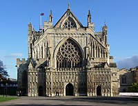
- Exeter Cathedral dominates the centre of the town. The first cathedral was founded in 1050 when the bishop's seat was moved from the nearby town of Crediton. It is the seat of the Bishop of Exeter. The present building was complete by about 1400, and has the longest uninterrupted vaulted ceiling in England, and other notable features.
John Betjeman described many of Exeter's Church of England churches:[24]
- St David's, described by ("Caroë's best church")
- St Martin's ("characteristic little city church, 15th century")
- St Mary Steps ("mediæval city church; font") - originally by the West Gate of the city. The font is Norman, and there is a remarkable early clock
- St Michael's ("Victorian, on a fine site")
- St Thomas
- St Mary Arches ("worth seeing ... as the completest Norman church in Devon: beautifully light and airy after its restoration from the bombing in 1942. 18th-century altar arrangements. Memorials to Exeter worthies, 16th to 18th centuries.")
Others include:
- St Edmund-on-the-Bridge built on the Exe Bridge ca. 1230-40. Two arches of the bridge remain under the undercroft though the church was rebuilt in the Perpendicular style in 1835, using the old materials.
- St Martin's in the Cathedral Close; the plan is odd, and there are numerous items of church furniture, though these are not of high aesthetic value. St Mary Arches is a Norman church with aisles. St Mary Steps was.
- St Michael, Heavitree, built in 1844-46 and extended later in the century.
- St Pancras - 13th century and has a nave and chancel only; the font is Norman.
- St Petroc's - highly unusual plan: a second chancel has been added facing north while the original chancel has another use and faces east. There are two aisles on the south, one of 1413 and another of the 16th century.
- St Sidwell's church - by W Burgess, 1812, in the perpendicular style.
- St Stephen's church - partly of the 13th century but most of the structure is as rebuilt in 1826.[25]
- St Michael and All Angels on Mount Dinham has a spire which exceeds the height of the towers of Exeter Cathedral.
Other ecclesiastical architecture
- St Nicholas Priory in Mint Lane, the remains of a monastery, later used as a private house and now a museum owned by the city council.
- A number of mediæval churches including St Mary Steps, which has an elaborate clock.
- The Exeter Synagogue is the third oldest Synagogue in Britain, completed in 1763.
Sights of the city
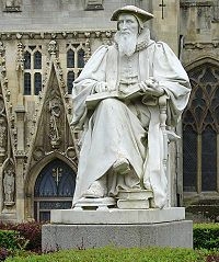
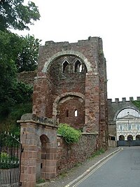
- The ruins of Rougemont Castle, built soon after the Norman Conquest; later parts of the castle were still in use as an assize court and later Crown Court until early 2006 when a new Crown Court building opened. A plaque near the ruined Norman gatehouse recalls that in 1685 Alice Molland, the last person executed for witchcraft in England, was imprisoned in Exeter. The future of the castle is at the moment uncertain, but moves are afoot to alter its use, possibly to a restaurant and housing.
- The Guildhall, the oldest municipal building in England still in use.
- Mols Coffee House Historic building in the Cathedral Close.
- The Guild of Tuckers and Weavers, a fine old building that is still used for smart functions.
- The Custom House in the attractive Quay area, which is the oldest brick building surviving in the city.
- "The House That Moved", a 14th-century Tudor building, earned its name in 1961 when it was moved from its original location on the corner of Edmund Street in order for a new road to be built in its place. Weighing more than twenty-one tonnes, it was strapped together and slowly moved a few inches at a time to its present-day position.
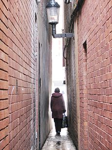
- Parliament Street in the city centre is the narrowest street in the United Kingdom.
- The Butts Ferry, an ancient cable ferry across the River Exe.
Many of the buildings are built in the local dark red sandstone, which gives its name to the castle and the park that now surrounds it (Rougemont means red hill). The pavements on Queen Street are composed of the rock diorite and exhibit some fine feldspar crystals, while those around Princesshay are composed of granodiorite.
Northernhay Gardens
Northernhay Gardens located just outside the castle, is the oldest public open space in the whole of England, being originally laid out in 1612 as a pleasure walk for Exeter residents. Much of Northernhay Gardens now represent Victorian design, with a beautiful display of trees, mature shrubs and bushes and plenty of flower beds. There are also many statues here, most importantly the war memorial by John Angel and the Deerstalker by E. B. Stephens. The Volunteer Memorial from 1895, also in the gardens, commemorates the formation of the 1st Rifle Volunteers in 1852, the first unit formed in the Victorian volunteer movement. Other statues include John Dinham, Thomas Dyke Acland and Stafford Northcote (a local landowner who was a Victorian Chancellor of the Exchequer).
Canal
The Exeter Canal was completed in about 1566,[26] making it one of the oldest artificial waterways in Britain. It was cut to bypass weirs that had been built across the River Exe to prevent trade in the city and to force boats to unload at Topsham from where the Earls of Devon were able to exact large tolls to transport goods to Exeter. Originally 3 feet deep and 16 feet wide, it ran 1.75 miles from just below the Countess Weir to the centre of Exeter. It was later extended to Topsham, deepened and widened, and was successful until the middle of the 19th century since when its use gradually declined – the last commercial use was in 1972. However it is now widely used for leisure purposes, and the city basin is being included as part of a £24 million redevelopment scheme.
Ancient books
The Exeter Book, an original manuscript and one of the most important documents in Anglo-Saxon literature, is kept in the vaults of the cathedral. The Exeter Book dates from the 10th century and is one of four manuscripts that between them contain virtually all the surviving poetry in the Old English language. It includes most of the more highly regarded shorter poems, some religious pieces, and a series of riddles, a handful of which are famously lewd. Some of the riddles are inscribed on a highly polished steel obelisk in the High Street, placed there on 30 March 2005.
The Exeter Domesday (so called from the preservation of the volume at Exeter), is a volume of Domesday Book that contains the full details which the original returns supplied, but only for part of south-west England, that is to say Cornwall, Devon, part of Somerset, part of Dorset and one manor of Wiltshire; it also contains a record of the geld of 1084 for the whole of these counties.[27][28][29]
References
- ↑ Oliver, George (1861). History of the City of Exeter. pp. 1.
- ↑ Dun & Bradstreet, 2001
- ↑ Hoskins 2004, p.1
- ↑ "Great Sites: Exeter Roman Baths". British Archaeology magazine. June 2002. http://www.britarch.ac.uk/ba/ba65/feat2.shtml. Retrieved 2008-07-12.
- ↑ "The Roman Fortress at Exeter: the Roman Bath House". Archived from the original on 2008-06-04. http://web.archive.org/web/20080604101008/http://www.exeter.gov.uk/timetrail/02_romanfortress/bath_house.htm. Retrieved 2008-07-12.
- ↑ Hoskins 2004, p.14
- ↑ Hoskins 2004, p.15
- ↑ Sellman 1985, p.16
- ↑ 9.0 9.1 9.2 9.3 Hoskins 2004, p.23
- ↑ 10.0 10.1 Sellman 1985, p.17
- ↑ Higham 2008, p.19
- ↑ Hoskins 2004, pp.26–27
- ↑ Hoskins 2004, pp.31–32
- ↑ Letters, Samantha. "Online Gazetteer of Markets and Fairs in England & Wales to 1516: Devon". Centre for Metropolitan History, Institute of Historical Research. http://www.history.ac.uk/cmh/gaz/devon.html#Exe. Retrieved 2009-07-26.
- ↑ "Exeter's Coat of Arms". Exeter City Council website. http://www.exeter.gov.uk/index.aspx?articleid=3469. Retrieved 2008-07-13.
- ↑ Gray 2000, p.16
- ↑ Gray 2000, p.18
- ↑ Gray 2000, p.31
- ↑ Oliver, George (1861). History of the City of Exeter. pp. 107.
- ↑ "High Street revamp plans criticised". BBC News. 2003-03-04. http://news.bbc.co.uk/1/hi/england/2817257.stm. Retrieved 2007-09-21.
- ↑ "Doors open at Princesshay". BBC Devon. 2007-09-20. http://www.bbc.co.uk/devon/content/articles/2007/09/19/princesshay_opening_day_feature.shtml. Retrieved 2007-09-21.
- ↑ "Heaven for shoppers as Princesshay gets off to a flying start with huge crowds for opening day". Express & Echo. 2007-09-21. http://www.thisisexeter.co.uk/displayNode.jsp?nodeId=142326&command=displayContent&sourceNode=142321&contentPK=18452155&folderPk=79876&pNodeId=142331. Retrieved 2007-09-21.
- ↑ "Key facts about Princesshay". Princesshay.com. Land Securities Group. http://www.princesshay.com/community/Keyfacts/index.aspx. Retrieved 2007-09-21.
- ↑ Betjeman, John, ed. (1968) Collins Pocket Guide to English Parish Churches; the South. London: Collins; p. 164
- ↑ Pevsner, N. (1952) South Devon. Harmondsworth: Penguin Books; pp. 148-53
- ↑ Clew, Kenneth R. (1984). The Exeter Canal. Chichester: Phillimore. ISBN 0-85033-544-2.
- ↑ Thorn, C., et al. (1979) Cornwall. (Domesday; vol. 10.) Chichester: Phillimore
- ↑ The Record Commission published the text in 1816 in vol. 3 of Domesday Book (including an account by Sir Henry Ellis). V. H. Galbraith gives a contents table of Exeter Domesday in his Domesday Book, 1974, pp. 184-88. R. W. Finn The Liber Exoniensis, 1964; and N. R. Ker Medieval Manuscripts in British Libraries, vol 2, pp. 800-07 are useful sources of information.
- ↑ "Liber Exoniensis". http://www.domesdaybook.net/helpfiles/hs710.htm. Retrieved 24 April 2010.
Outside links
- History of Exeter from White's Devonshire Directory, 1850
- The Cathedral Town, Time-Travel Britain
- Exeter City Council