Cwmcarvan: Difference between revisions
Created page with '{{Infobox town |name=Cwmcarvan |welsh=Cwmcarfan |county=Monmouthshire |picture=Cwmcarvan.jpg |picture caption=Cwmcarvan fields from the church tower |os grid ref=SO476075 |latitu…' |
No edit summary |
||
| Line 14: | Line 14: | ||
|LG district=Monmouthshire | |LG district=Monmouthshire | ||
|constituency=Monmouth | |constituency=Monmouth | ||
}}'''Cwmcarvan''' is a small village in the depths of rural [[Monmouthshire]]. It is | }}'''Cwmcarvan''' is a small village in the depths of rural [[Monmouthshire]]. It is four miles southwest of the county town, [[Monmouth]] and about four miles east of [[Raglan, Monmouthshire|Raglan]], off the old A40 road not far from [[Trellech]]. | ||
==Church of St Catwg== | ==Church of St Catwg== | ||
| Line 23: | Line 23: | ||
===Craig-y-Dorth=== | ===Craig-y-Dorth=== | ||
{{main|Craig-y-Dorth}} | {{main|Craig-y-Dorth}} | ||
The hill of Craig-y-Dorth, | The hill of Craig-y-Dorth, a mile north east of the church, was the site of a battle in 1404 between Owain Glyndŵr's rebels and those of the Crown. According to the ''Annals of Owain Glyn Dwr'', ''"Here the more part of the English were slain and they were chased up to the town gate'' [of Monmouth]".<ref>[http://www.deremilitari.org/resources/sources/owainglyndwr.htm Annals of Owain Glyn Dwr]</ref> | ||
===High Glanau=== | ===High Glanau=== | ||
Revision as of 09:34, 5 August 2014
| Cwmcarvan Welsh: Cwmcarfan | |
| Monmouthshire | |
|---|---|
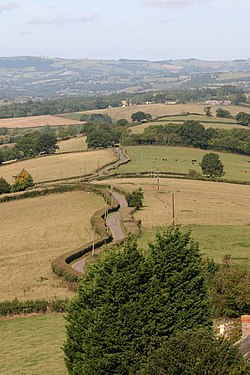
 Cwmcarvan fields from the church tower | |
| Location | |
| Grid reference: | SO476075 |
| Location: | 51°45’49"N, 2°45’33"W |
| Data | |
| Post town: | Monmouth |
| Postcode: | NP25 |
| Dialling code: | 01600 |
| Local Government | |
| Council: | Monmouthshire |
| Parliamentary constituency: |
Monmouth |
Cwmcarvan is a small village in the depths of rural Monmouthshire. It is four miles southwest of the county town, Monmouth and about four miles east of Raglan, off the old A40 road not far from Trellech.
Church of St Catwg

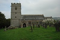
The church dates from the 13th or 14th century, in the Early English and Perpendicular styles, with some 16th-century features. It was heavily restored in the 1870s.[1] The dedication is to St. Catwg or Cadoc, a Welsh saint of the 6th century. There are porches on both the south and north sides, supposedly so that the squires of Cwmbychan and Trevildu within the parish did not have to enter through the same door as each other.[2]
Nearby places
Craig-y-Dorth
- Main article: Craig-y-Dorth
The hill of Craig-y-Dorth, a mile north east of the church, was the site of a battle in 1404 between Owain Glyndŵr's rebels and those of the Crown. According to the Annals of Owain Glyn Dwr, "Here the more part of the English were slain and they were chased up to the town gate [of Monmouth]".[3]
High Glanau
The house at High Glanau was built in 1923 for the writer and garden designer Henry Avray Tipping.[1]
Outside links
References
- ↑ 1.0 1.1 John Newman, The Buildings of Wales: Gwent/Monmouthshire, 2000, ISBN 0-14-071053-1
- ↑ Sir Joseph Bradney, A History of Monmouthshire, vol.2 part 2, 1913
- ↑ Annals of Owain Glyn Dwr