Difference between revisions of "Monkland"
From Wikishire
(Created page with "{{Infobox town |name=Monkland |county=Herefordshire |picture=St Cosmas and St Damian, Stretford - geograph.org.uk - 702040.jpg |picture caption=St Cosmas and St Damian, Monkla...") |
m (RB moved page Monkland, Herefordshire to Monkland) |
(No difference)
| |
Revision as of 19:44, 8 September 2019
| Monkland | |
| Herefordshire | |
|---|---|
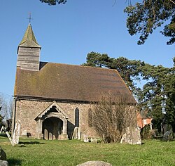
 St Cosmas and St Damian, Monkland | |
| Location | |
| Grid reference: | SO459576 |
| Location: | 52°12’52"N, 2°47’33"W |
| Data | |
| Postcode: | HR6 |
| Local Government | |
| Council: | Herefordshire |
Monkland is a small village in Herefordshire in the meadows on the south bank of the River Arrow, close about two and a half miles west of Leominster, and just off the A44 road. To the south-west is another hamlet, Stretford (with which Monkland shares a civil parish) and to the south-east is Ivington.
The village is the start of the Black and White Village Trail. Its most notable building is the parish church, St Cosmas and St Damian's Church, which is a Grade I listed building.[1]
Geography
The River Arrow runs to the east of the village.
Outside links
| ("Wikimedia Commons" has material about Monkland) |
References
- ↑ National Heritage List 1349846: Church of Saints Cosmas and Damian, Monkland