Richmond Falls: Difference between revisions
Jump to navigation
Jump to search
Created page with "{{Infobox waterfall |name=Richmond Falls |county=York |riding=North |picture=The River Swale at Richmond - geograph.org.uk - 271390.jpg |picture caption=Part of the Richmond F..." |
No edit summary |
||
| Line 16: | Line 16: | ||
{{clear}} | {{clear}} | ||
{{wide image|Richmond falls panorama.JPG|950px| | {{wide image|Richmond falls panorama.JPG|950px|The Richmond Falls}} | ||
==References== | ==References== | ||
{{reflist}} | {{reflist}} | ||
Revision as of 21:06, 23 June 2019
| Richmond Falls | |
| Yorkshire | |
|---|---|
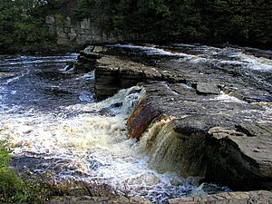
 Part of the Richmond Falls | |
| River: | River Swale |
| NZ17390061 | |
| Co-ordinates: | 54°24’4"N, 1°44’3"W |
Richmond Falls are found on the River Swale by Richmond in the North Riding of Yorkshire. These are a series of low waterfalls where the river tumbles over rocks in the stretch of the river that narrows passing the hill on which Richmond stands.[1]
They are one of the last waterfalls on the Swale before the river reaches the lower country grounds of the Vale of Mowbray, and are normally of modest size bu they can be affected easily, much like the rest of the Swale, by heavy rain and flooding, making for dramatic viewing. Because of the steep nature of the rocks, the falls are a barrier to fish passage upstream.[2]
References
- ↑ Fellows, Griff J (2003). The waterfalls of England : a practical guide for visitors and walkers. Wilmslow: Sigma Leisure. p. 133. ISBN 1-85058-767-1.
- ↑ "Upper Swale Sub-Catchment Evidence Pack for the Water Framework Directive" (PDF). p. 1. http://www.yorkshiredalesriverstrust.com/wp-content/uploads/2014/03/Upper-Swale-Sub-Catchment-Evidence-Pack.pdf. Retrieved 21 June 2019.
