Camptown: Difference between revisions
Jump to navigation
Jump to search
Created page with "{{Infobox town |name=Camptown |county=Roxburghshire |picture=Camptown - geograph.org.uk - 2132850.jpg |picture caption=Camptown |os grid ref=NT679134 |latitude=55.4147 |longit..." |
mNo edit summary |
||
| Line 15: | Line 15: | ||
|website= | |website= | ||
}} | }} | ||
'''Camptown''' is a small village on the A68, in the [[Cheviot Hills]] in [[Roxburghshire]], five miles south of [[Jedburgh]], and the same distance north of the | '''Camptown''' is a small village on the A68, in the [[Cheviot Hills]] in [[Roxburghshire]], five miles south of [[Jedburgh]], and the same distance north of the boundary of [[Northumberland]] at [[Carter Bar]]. | ||
The village stands beside the course of the [[Jed Water]], in a small, steep-sided valley. To the south, on the hillslope climbing up from the burn, are the remains of a peel tower. | The village stands beside the course of the [[Jed Water]], in a small, steep-sided valley. To the south, on the hillslope climbing up from the burn, are the remains of a peel tower. | ||
Latest revision as of 23:10, 6 December 2016
| Camptown | |
| Roxburghshire | |
|---|---|
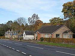
 Camptown | |
| Location | |
| Grid reference: | NT679134 |
| Location: | 55°24’53"N, 2°30’29"W |
| Data | |
| Post town: | Jedburgh |
| Postcode: | TD8 |
| Local Government | |
| Council: | Scottish Borders |
Camptown is a small village on the A68, in the Cheviot Hills in Roxburghshire, five miles south of Jedburgh, and the same distance north of the boundary of Northumberland at Carter Bar.
The village stands beside the course of the Jed Water, in a small, steep-sided valley. To the south, on the hillslope climbing up from the burn, are the remains of a peel tower.
Other places nearby are Bairnkine, Bonchester Bridge, Crailing, Edgerston, Ferniehirst Castle, Hobkirk, the Jed Water, Mossburnford, Newbigging and Oxnam.
Outside links
| ("Wikimedia Commons" has material about Camptown) |
