Glasgwm: Difference between revisions
mNo edit summary |
No edit summary |
||
| Line 6: | Line 6: | ||
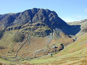
|picture caption=Craig Cywarch, the southern face of Glasgwm | |picture caption=Craig Cywarch, the southern face of Glasgwm | ||
|os grid ref=SH836194 | |os grid ref=SH836194 | ||
|latitude=52.759626 | |||
|longitude=-3.72635 | |||
|height=2,559 feet | |height=2,559 feet | ||
}} | }} | ||
'''Glasgwm''' is a mountain in [[Radnorshire]], forming part of the [[Aran Hills]], the highest of the [[Cambrian Mountains]], south of [[Snowdonia]]. Glasgwm reaches a height at its summit of 2,559 feet above sea level and it is one of the three 'Marilyns' that make up the Aran group, the others being in neighbouring [[Merionethshire]] - [[Aran Fawddwy]] (the latter's [[county top]]) and [[Esgeiriau Gwynion]]. | '''Glasgwm''' is a mountain in [[Radnorshire]], forming part of the [[Aran Hills]], the highest of the [[Cambrian Mountains]], south of [[Snowdonia]]. Glasgwm reaches a height at its summit of 2,559 feet above sea level and it is one of the three 'Marilyns' that make up the Aran group, the others being in neighbouring [[Merionethshire]] - [[Aran Fawddwy]] (the latter's [[county top]]) and [[Esgeiriau Gwynion]]. | ||
To the west, across in [[Merionethshire]], stand [[Maesglase]] and the [[Dovey Hills]] and to the | To the west, across in [[Merionethshire]], stand [[Maesglase]] and the [[Dovey Hills]] and to the south-west [[Cadair Idris]]. To the south stands the [[Plynlimon]] range. high.<ref>{{cite web|url=http://www.mountaindays.net/mountains/peak.php?defn=0&area=5&peak=2091 |title=Mountaineering & Rock Climbing in the UK: Glasgwm |accessdate=2008-04-08 |last=Crocker |first=Chris |author2=Graham Jackson |work=Database of British Hills |publisher=Mountain Days.net }}</ref> | ||
==Crags and summits== | ==Crags and summits== | ||
Revision as of 09:13, 15 September 2018
| Glasgwm | |||
| Radnorshire | |||
|---|---|---|---|
 Craig Cywarch, the southern face of Glasgwm | |||
| Range: | Aran Hills | ||
| Summit: | 2,559 feet SH836194 52°45’35"N, 3°43’35"W | ||
Glasgwm is a mountain in Radnorshire, forming part of the Aran Hills, the highest of the Cambrian Mountains, south of Snowdonia. Glasgwm reaches a height at its summit of 2,559 feet above sea level and it is one of the three 'Marilyns' that make up the Aran group, the others being in neighbouring Merionethshire - Aran Fawddwy (the latter's county top) and Esgeiriau Gwynion.
To the west, across in Merionethshire, stand Maesglase and the Dovey Hills and to the south-west Cadair Idris. To the south stands the Plynlimon range. high.[1]
Crags and summits
The main summit stands at 2,559 feet, a large rocky knoll marked by a cairn. The main subsidiary summits are:
- Pen y Brynfforchog, 2,247 feet, Grid reference SH817179
- Y Gribin, 1,969 feet, Grid reference SH843177
Craig Cywarch makes up the south face of Glasgwm. Its crags are very popular with rock climbers. A mountaineering club hut is found at the foot of the cliffs.
A tarn named Llyn y Fign lies close by the summit, and is one of the largest bodies of water in England and Wales found adjacent to a summit of over 2,000 feet.[2]
References
- ↑ Crocker, Chris; Graham Jackson. "Mountaineering & Rock Climbing in the UK: Glasgwm". Database of British Hills. Mountain Days.net. http://www.mountaindays.net/mountains/peak.php?defn=0&area=5&peak=2091. Retrieved 2008-04-08.
- ↑ Nuttall, John & Anne (1999). The Mountains of England & Wales - Volume 1: Wales (2nd edition ed.). Milnthorpe, Cicerone. ISBN 1-85284-304-7.