Warwick Parish: Difference between revisions
Created page with "{{Infobox island parish |name=Warwick Parish |territory=Bermuda |picture=CHRIST CHURCH, WARWICK PARISH, BERMUDA.jpg |picture caption=Christ Church |map=Warwick Parish, Bermuda..." |
mNo edit summary |
||
| Line 10: | Line 10: | ||
'''Warwick Parish''' is one of the nine parishes of Bermuda. It is named for Robert Rich, 2nd Earl of Warwick (1587-1658). | '''Warwick Parish''' is one of the nine parishes of Bermuda. It is named for Robert Rich, 2nd Earl of Warwick (1587-1658). | ||
It is located in the central south of the island chain, occupying part of the main island to the southeast of the [[Great Sound, Bermuda|Great Sound]], the large expanse of water which dominates the geography of western Bermuda, and also the greater part of the many islands which lie scattered within that sound. It is joined to [[ | It is located in the central south of the island chain, occupying part of the main island to the southeast of the [[Great Sound, Bermuda|Great Sound]], the large expanse of water which dominates the geography of western Bermuda, and also the greater part of the many islands which lie scattered within that sound. It is joined to [[Southampton Parish]] in the southwest, and to [[Paget Parish]] in the northeast. As with most of Bermuda's parishes, it covers just over 2.3 square miles or 1500 acres). | ||
==About the parish== | ==About the parish== | ||
Latest revision as of 21:25, 24 October 2014
| Warwick Parish | |
| Bermuda | |
|---|---|
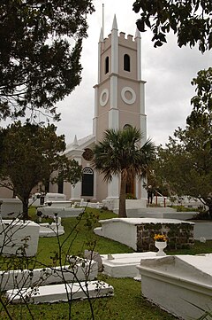
 Christ Church | |
 | |
| Location: | 32.2666667 -64.80833 |
Warwick Parish is one of the nine parishes of Bermuda. It is named for Robert Rich, 2nd Earl of Warwick (1587-1658).
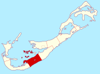
It is located in the central south of the island chain, occupying part of the main island to the southeast of the Great Sound, the large expanse of water which dominates the geography of western Bermuda, and also the greater part of the many islands which lie scattered within that sound. It is joined to Southampton Parish in the southwest, and to Paget Parish in the northeast. As with most of Bermuda's parishes, it covers just over 2.3 square miles or 1500 acres).
About the parish
Natural features in Warwick include Warwick Long Bay, Riddell's Bay, Darrell's Island, Hawkins Island, Long Island, and Marshall's Island. Hinson's Island, once part of Warwick, is now part of Paget Parish.
The parish also contains Warwick Camp, the former rifle ranges of the Imperial military garrison, which is, today, the home of the Bermuda Regiment, and most of which doubles as parkland (and the territory of which includes Warwick Long Bay, Horseshoe Bay, and the smaller beaches between).
Christ Church on Middle Road, Warwick is one of the world's oldest Presbyterian churches outside of Europe. It was founded in 1719 and is part of the Church of Scotland.
Warwick Pond was designated a Ramsar site in 1999.
Outside links
| ("Wikimedia Commons" has material about Warwick Parish) |
| Parishes of Bermuda |
|---|
|
Devonshire • Hamilton • Paget • Pembroke • St George's • Sandys • Smith's • Southampton • Warwick |
Coordinates: 32°16′00″N 64°48′30″W / 32.2666667°N 64.80833°W
