Walna Scar Road: Difference between revisions
Created page with 'right|thumb|350px|The Walna Scar Road Heading west towards Brown Pike [[File:A cosy little shelter on the Walna Scar …' |
mNo edit summary |
||
| Line 1: | Line 1: | ||
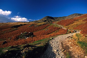
[[File:The Walna Scar Road - geograph.org.uk - 1015748.jpg|right|thumb|350px|The Walna Scar Road Heading west towards Brown Pike]] | [[File:The Walna Scar Road - geograph.org.uk - 1015748.jpg|right|thumb|350px|The Walna Scar Road Heading west towards Brown Pike]] | ||
[[File:A cosy little shelter on the Walna Scar Road - geograph.org.uk - 1372983.jpg|right|thumb|250px|Stone shelter on the road]] | [[File:A cosy little shelter on the Walna Scar Road - geograph.org.uk - 1372983.jpg|right|thumb|250px|Stone shelter on the road]] | ||
'''The Walna Scar Road'' is an ancient trackway over the [[Furness Fells]] of [[Lancashire]] running from [[River Duddon|Dunnerdale]] in the west to [[Coniston Water]] in the east. It has a summit at 1,985 feet on [[Walna Scar]]. | '''The Walna Scar Road''' is an ancient trackway over the [[Furness Fells]] of [[Lancashire]] running from [[River Duddon|Dunnerdale]] in the west to [[Coniston Water]] in the east. It has a summit at 1,985 feet on [[Walna Scar]]. | ||
At [[Seathwaite, Lancashire|Seathwaite]], a village on the Lancashire side of the [[River Duddon]], the way begins at {{map|SD229962}} as a metalled road, which ends after a mile at {{map|SD240968|Long House}} and continues eastward as a public bridleway. After leaving the Long House Gill the road passes over the flank of [[Walna Scar]] with a good view of that fell's quarries, which in their day were the made the road a busy highway bearing stone over to Coniston. | At [[Seathwaite, Lancashire|Seathwaite]], a village on the Lancashire side of the [[River Duddon]], the way begins at {{map|SD229962}} as a metalled road, which ends after a mile at {{map|SD240968|Long House}} and continues eastward as a public bridleway. After leaving the Long House Gill the road passes over the flank of [[Walna Scar]] with a good view of that fell's quarries, which in their day were the made the road a busy highway bearing stone over to Coniston. | ||
A steep climb over the ridge that forms the watershed between the dales reaches the path summit, and eastward of this the road passes under the gaze of the [[Old Man of | A steep climb over the ridge that forms the watershed between the dales reaches the path summit, and eastward of this the road passes under the gaze of the [[Old Man of Coniston]] and further quarries before descending gently to the village of [[Coniston]], resuming on tarmacked road at {{map|SD289970}}. | ||
==Nature of the road== | ==Nature of the road== | ||
Latest revision as of 20:25, 20 June 2013


The Walna Scar Road is an ancient trackway over the Furness Fells of Lancashire running from Dunnerdale in the west to Coniston Water in the east. It has a summit at 1,985 feet on Walna Scar.
At Seathwaite, a village on the Lancashire side of the River Duddon, the way begins at SD229962 as a metalled road, which ends after a mile at Long House and continues eastward as a public bridleway. After leaving the Long House Gill the road passes over the flank of Walna Scar with a good view of that fell's quarries, which in their day were the made the road a busy highway bearing stone over to Coniston.
A steep climb over the ridge that forms the watershed between the dales reaches the path summit, and eastward of this the road passes under the gaze of the Old Man of Coniston and further quarries before descending gently to the village of Coniston, resuming on tarmacked road at SD289970.
Nature of the road
It is believed that the Walna Scar Road was originally constructed to facilitate local trade and it also served the many slate quarries which can be seen scarring the fells here, provides a good crossing between Coniston and Seathwaite.
When the road was created is unknown. The Complete Guide to the Lakes in 1853 talks of the road, and that "Horses may be taken over this mountain track, which is, however, in places very steep and difficult." At page 17 it calls it "the ancient horse-road over Walna Scar", and other publications call it "the old pack-horse road". It is certainly older than this: it appears on a map of 1745 and indeed a it was important enough by then that it had a bridge, name on the map as 'New Brig', and records from 1680 show the road's use by quarrymen.[1] . It is a broad track, a public byway, primarily a pedestrian route and, although carts once plied the road and it was maintained by the parish as a road. From the twentieth century motorbikes not infrequent and indeed a race was held here once. With the coming of bigger off-road vehicles, the attendant erosion became alarming and in 2012 all motorised vehicles were banned form the road. The first section at either end is paved although the remainder is a stony bridleway.