Glasgwm: Difference between revisions
mNo edit summary |
No edit summary |
||
| (One intermediate revision by the same user not shown) | |||
| Line 1: | Line 1: | ||
{{Infobox hill | {{Infobox hill | ||
|name=Glasgwm | |name=Glasgwm | ||
|county= | |county=Merioneth | ||
|range=Aran Hills | |range=Aran Hills | ||
|picture=The head of Cwm Cywarch - geograph.org.uk - 547375.jpg | |picture=The head of Cwm Cywarch - geograph.org.uk - 547375.jpg | ||
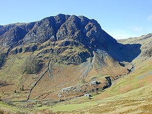
|picture caption=Craig Cywarch, the southern face of Glasgwm | |picture caption=Craig Cywarch, the southern face of Glasgwm | ||
|os grid ref=SH836194 | |os grid ref=SH836194 | ||
|latitude=52.759626 | |||
|longitude=-3.72635 | |||
|height=2,559 feet | |height=2,559 feet | ||
}} | }} | ||
'''Glasgwm''' is a mountain in [[ | '''Glasgwm''' is a mountain in [[Merionethshire]], forming part of the [[Aran Hills]], the highest of the [[Cambrian Mountains]], south of [[Snowdonia]]. Glasgwm reaches a height at its summit of 2,559 feet above sea level and it is one of the three 'Marilyns' that make up the Aran group, the others being [[Aran Fawddwy]] (the [[county top]]) and [[Esgeiriau Gwynion]]. | ||
To the west | To the west stand [[Maesglase]] and the [[Dovey Hills]] and to the south-west [[Cadair Idris]]. To the south stands the [[Plynlimon]] range.<ref>{{cite web|url=http://www.mountaindays.net/mountains/peak.php?defn=0&area=5&peak=2091 |title=Mountaineering & Rock Climbing in the UK: Glasgwm |accessdate=2008-04-08 |last=Crocker |first=Chris |author2=Graham Jackson |work=Database of British Hills |publisher=Mountain Days.net }}</ref> | ||
==Crags and summits== | ==Crags and summits== | ||
Latest revision as of 09:38, 15 September 2018
| Glasgwm | |||
| Merionethshire | |||
|---|---|---|---|
 Craig Cywarch, the southern face of Glasgwm | |||
| Range: | Aran Hills | ||
| Summit: | 2,559 feet SH836194 52°45’35"N, 3°43’35"W | ||
Glasgwm is a mountain in Merionethshire, forming part of the Aran Hills, the highest of the Cambrian Mountains, south of Snowdonia. Glasgwm reaches a height at its summit of 2,559 feet above sea level and it is one of the three 'Marilyns' that make up the Aran group, the others being Aran Fawddwy (the county top) and Esgeiriau Gwynion.
To the west stand Maesglase and the Dovey Hills and to the south-west Cadair Idris. To the south stands the Plynlimon range.[1]
Crags and summits
The main summit stands at 2,559 feet, a large rocky knoll marked by a cairn. The main subsidiary summits are:
- Pen y Brynfforchog, 2,247 feet, Grid reference SH817179
- Y Gribin, 1,969 feet, Grid reference SH843177
Craig Cywarch makes up the south face of Glasgwm. Its crags are very popular with rock climbers. A mountaineering club hut is found at the foot of the cliffs.
A tarn named Llyn y Fign lies close by the summit, and is one of the largest bodies of water in England and Wales found adjacent to a summit of over 2,000 feet.[2]
References
- ↑ Crocker, Chris; Graham Jackson. "Mountaineering & Rock Climbing in the UK: Glasgwm". Database of British Hills. Mountain Days.net. http://www.mountaindays.net/mountains/peak.php?defn=0&area=5&peak=2091. Retrieved 2008-04-08.
- ↑ Nuttall, John & Anne (1999). The Mountains of England & Wales - Volume 1: Wales (2nd edition ed.). Milnthorpe, Cicerone. ISBN 1-85284-304-7.