Grange-over-Sands: Difference between revisions
Created page with '{{Infobox town |name=Grange-over-Sands |county=Lancashire |picture=Morecambe Bay from Grange-over-Sands - geograph.org.uk - 267659.jpg |picture caption=Looking out over Morecambe…' |
mNo edit summary |
||
| (One intermediate revision by one other user not shown) | |||
| Line 16: | Line 16: | ||
'''Grange-over-Sands''' is a town in [[Lancashire]], by the broad sea sands on the eastern side of the [[Furness]] coast; part of Lancashire North of the Sands. | '''Grange-over-Sands''' is a town in [[Lancashire]], by the broad sea sands on the eastern side of the [[Furness]] coast; part of Lancashire North of the Sands. | ||
The town lies on the western side of the [[River Kent|Kent]] estuary. The River Kent used to flow past the town's mile-long Promenade, but the river's course changes over time, and has migrated south, away from Grange. The sands from which the town takes part of its name are the mudflats of the estuary, not rich sands but mudflats with invisible, dangerous quicksands, though since the river shifted away, | The town lies on the western side of the [[River Kent|Kent]] estuary. The River Kent used to flow past the town's mile-long Promenade, but the river's course changes over time, and it has migrated south, away from Grange. The sands from which the town takes part of its name are the mudflats of the estuary, not rich sands but mudflats with invisible, dangerous quicksands, though since the river shifted away, these have become a grass meadow now frequently grazed over by small flocks of sheep. The river though is still moving and may in coming years swamp the meadow once more. | ||
==The path across the sands== | ==The path across the sands== | ||
The two parts of Lancashire are joined by the sands, though at high tide the Irish Sea beats between them. The estuary has a wide tidal range and at the flood the estuary at Grange is over a mile and a half wide. | The two parts of Lancashire are joined by the sands, though at high tide the [[Irish Sea]] beats between them. The estuary has a wide tidal range and at the flood the estuary at Grange is over a mile and a half wide. | ||
An ancient footpath across the sands, a public right of way, is still marked on the maps from [[Hest Bank]] on the other side of | An ancient footpath across the sands, a public right of way, is still marked on the maps from [[Hest Bank]] on the other side of Morecambe Bay to Kent's Bank south of Grange, and another route runs the eight miles over the sands between Grange-over-Sands and [[Arnside]] in [[Westmorland]]. Only at the ebb is it possible to walk across the sands, but even then the sands are treacherous and the tide swift, and without an experienced guide, setting forth on the footpath will often be a fatal undertaking. | ||
Before the railway these routes were the main land route to Furness, but it was always hazardous. The King's Guide to the Sands was first employed by King Henry VIII to lead travellers across the treacherous sands, and the position is still maintained; the Queen's Guide to the Sands will still lead the intrepid across the bay from Arnside, or once a year from Hest Bank, testing the ever-changing surface, watching for the quicksands, placing hazel trigs in the sand as he goes to mark the way. | Before the railway these routes were the main land route to Furness, but it was always hazardous. The King's Guide to the Sands was first employed by King Henry VIII to lead travellers across the treacherous sands, and the position is still maintained; the Queen's Guide to the Sands will still lead the intrepid across the bay from Arnside, or once a year from Hest Bank, testing the ever-changing surface, watching for the quicksands, placing hazel trigs in the sand as he goes to mark the way. | ||
| Line 43: | Line 43: | ||
==Recent developments== | ==Recent developments== | ||
A new public swimming pool, the Berners Pool, opened in 2003. It won a | A new public swimming pool, the Berners Pool, opened in 2003. It won a RIBA Design Award in 2004,<ref>[http://arts.guardian.co.uk/pictures/image/0,8543,-10404950018,00.html Guardian News and Media : RIBA Award Winners 2004 : Berners Pool''] Retrieved 2009-09-18</ref> but closed in 2006 after suffering financial and structural problems and as of May 2009 is awaiting demolition.<ref>[http://www.therubbleclub.com/2009/05/berners-pool-hodders-associates-cumbri/ The Rubble Club : ''Berners Pool : Hodder Associates : Cumbria''] Retrieved 2009-09-18</ref> A new pool and leisure centre is planned as part of the redevelopment of the site.<ref>[http://www.southlakeland.gov.uk/default.aspx?page=2990 South Lakeland District Council : 12 November 2008 : ''Winning Developer Revealed for Grange Pool Site''] Retrieved 2009-09-18</ref> | ||
==References== | ==References== | ||
Latest revision as of 15:09, 14 November 2017
| Grange-over-Sands | |
| Lancashire | |
|---|---|
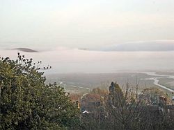
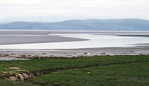
 Looking out over Morecambe Bay | |
| Location | |
| Grid reference: | SD402775 |
| Location: | 54°11’24"N, 2°54’57"W |
| Data | |
| Population: | 4,042 |
| Post town: | Grange-over-Sands |
| Postcode: | LA11 |
| Dialling code: | 015395 |
| Local Government | |
| Council: | Westmorland & Furness |
| Parliamentary constituency: |
Westmorland and Lonsdale |
Grange-over-Sands is a town in Lancashire, by the broad sea sands on the eastern side of the Furness coast; part of Lancashire North of the Sands.
The town lies on the western side of the Kent estuary. The River Kent used to flow past the town's mile-long Promenade, but the river's course changes over time, and it has migrated south, away from Grange. The sands from which the town takes part of its name are the mudflats of the estuary, not rich sands but mudflats with invisible, dangerous quicksands, though since the river shifted away, these have become a grass meadow now frequently grazed over by small flocks of sheep. The river though is still moving and may in coming years swamp the meadow once more.
The path across the sands
The two parts of Lancashire are joined by the sands, though at high tide the Irish Sea beats between them. The estuary has a wide tidal range and at the flood the estuary at Grange is over a mile and a half wide.
An ancient footpath across the sands, a public right of way, is still marked on the maps from Hest Bank on the other side of Morecambe Bay to Kent's Bank south of Grange, and another route runs the eight miles over the sands between Grange-over-Sands and Arnside in Westmorland. Only at the ebb is it possible to walk across the sands, but even then the sands are treacherous and the tide swift, and without an experienced guide, setting forth on the footpath will often be a fatal undertaking.
Before the railway these routes were the main land route to Furness, but it was always hazardous. The King's Guide to the Sands was first employed by King Henry VIII to lead travellers across the treacherous sands, and the position is still maintained; the Queen's Guide to the Sands will still lead the intrepid across the bay from Arnside, or once a year from Hest Bank, testing the ever-changing surface, watching for the quicksands, placing hazel trigs in the sand as he goes to mark the way.
History
The town developed from a small fishing village in the Victorian era with the arrival of the railway as it became a popular seaside resort, lying on the north side of Morecambe Bay, across the sands from Morecambe itself. In 1932 a lido was built on the seafront but it closed in 1993.[1]
Sanatorium
The clean, salty air was believed to be of benefit to tuberculosis sufferers, and in 1891 one of the first sanatoriums in the country was established at Meathop. Not only was the local air believed to have a therapeutic effect but also the local spring water.[2]
Tourism

The town is a centre for tourists exploring the southern Lakeland Fells. Within the town itself there is an ornamental duck pond and a traffic-free promenade.
Above the town is Hampsfield Fell (generally abbreviated to Hampsfell), crowned by 'Hampsfell Hospice', a sturdy limestone tower monument offering shelter to the rain-drenched walker, as well as the finest viewpoint of all the foothills of the outlying southern Lakeland fells. On the roof, a large compass pointer and list of peaks identify the greater and lesser landmarks in the magnificent panorama. Inside, painted boards commemorate its construction, praise the view and welcome the visitor.
Adjacent to Grange are Lindale, to the north-east, Cartmel to the north-west, with its Priory to which the village was once the 'grange' or farm, and Allithwaite to the west. The country house Holker Hall, which was built on land which once belonged to the Priory, is nearby. The stables at Holker Hall house the Lakeland Motor Museum.
Transport
Grange-over-Sands railway station, which serves the town, is situated on the Furness Line, giving connections to Ulverston and Barrow-in-Furness to the west, and Lancaster, Preston and Manchester to the east. The nearest Airport is Blackpool, 60 miles away.
Recent developments
A new public swimming pool, the Berners Pool, opened in 2003. It won a RIBA Design Award in 2004,[3] but closed in 2006 after suffering financial and structural problems and as of May 2009 is awaiting demolition.[4] A new pool and leisure centre is planned as part of the redevelopment of the site.[5]
References
- ↑ Oliver Merrington's Potentially Re-Openable Lidos in the UK, retrieved 14 November 2009
- ↑ Golakes - Grange over Sands History, retrieved 9th July 2010
- ↑ Guardian News and Media : RIBA Award Winners 2004 : Berners Pool Retrieved 2009-09-18
- ↑ The Rubble Club : Berners Pool : Hodder Associates : Cumbria Retrieved 2009-09-18
- ↑ South Lakeland District Council : 12 November 2008 : Winning Developer Revealed for Grange Pool Site Retrieved 2009-09-18
Outside links
- Welcome to Grange over Sands
- Guide to Morecambe Bay walk
- Cedric keeps danger sands at bay BBC News (Sunday, 5 February 2006)