Braeriach: Difference between revisions
Created page with '{{Infobox hill |name=Braeriach |county 1=Aberdeenshire |county 2=Inverness-shire |picture=Braeriach.jpg |picture caption=Braeriach seen from Sgor Gaoith, across Glen Einich |heig…' |
No edit summary |
||
| (2 intermediate revisions by one other user not shown) | |||
| Line 3: | Line 3: | ||
|county 1=Aberdeenshire | |county 1=Aberdeenshire | ||
|county 2=Inverness-shire | |county 2=Inverness-shire | ||
|SMC=8 | |||
|picture=Braeriach.jpg | |picture=Braeriach.jpg | ||
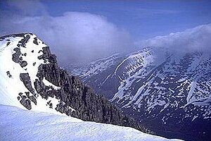
|picture caption=Braeriach seen from Sgor Gaoith, across Glen Einich | |picture caption=Braeriach seen from Sgor Gaoith, across Glen Einich | ||
| Line 8: | Line 9: | ||
|range=Cairngorms | |range=Cairngorms | ||
|os grid ref=NN953999 | |os grid ref=NN953999 | ||
|latitude=57.0783 | |||
|longitude=-3.7274 | |||
}} | }} | ||
'''Braeriach''' ({{lang|gd|Bràigh Riabhach ''or'' Am Bràigh Riabhach}}) is a mountain of the [[Cairngorms]] and is the third highest mountain in [[Great Britain]], surpassed only by [[Ben Nevis]] and [[Ben Macdui]]. | '''Braeriach''' ({{lang|gd|Bràigh Riabhach ''or'' Am Bràigh Riabhach}}) is a mountain of the [[Cairngorms]] and is the third highest mountain in [[Great Britain]], surpassed only by [[Ben Nevis]] and [[Ben Macdui]]. | ||
| Line 13: | Line 16: | ||
Braeiach stands on the border of [[Aberdeenshire]] and [[Inverness-shire]] and is the highest point in the western massif of the [[Cairngorms]], separated from the central section (which contains Ben Macdui and [[Cairn Gorm]]) by the pass of the [[Lairig Ghru]]. | Braeiach stands on the border of [[Aberdeenshire]] and [[Inverness-shire]] and is the highest point in the western massif of the [[Cairngorms]], separated from the central section (which contains Ben Macdui and [[Cairn Gorm]]) by the pass of the [[Lairig Ghru]]. | ||
The mountain's summit has a crescent shape, with several corries. In the north-facing corrie of Garbh Coire Mor the snow has completely melted just | The mountain's summit has a crescent shape, with several corries. In the north-facing corrie of Garbh Coire Mor the snow has completely melted just five times in the last century: 1933, 1959, 1996, 2003 & 2006 <ref>Royal Meteorological Society "Weather" March 2007 vol62, no.3</ref> and the patches that linger there are the longest lying snow patches in Scotland. | ||
The mountain's name is Gaelic, and means "Brindled greyish upper part". | The mountain's name is Gaelic, and means "Brindled greyish upper part". | ||
| Line 23: | Line 26: | ||
{{reflist}} | {{reflist}} | ||
{{Munro}} | |||
Latest revision as of 09:20, 12 July 2024
| Braeriach | |||
| Aberdeenshire, Inverness-shire | |||
|---|---|---|---|
 Braeriach seen from Sgor Gaoith, across Glen Einich | |||
| Range: | Cairngorms | ||
| Summit: | 4,252 feet NN953999 57°4’42"N, 3°43’39"W | ||
Braeriach (Gaelic: Bràigh Riabhach or Am Bràigh Riabhach) is a mountain of the Cairngorms and is the third highest mountain in Great Britain, surpassed only by Ben Nevis and Ben Macdui.
Braeiach stands on the border of Aberdeenshire and Inverness-shire and is the highest point in the western massif of the Cairngorms, separated from the central section (which contains Ben Macdui and Cairn Gorm) by the pass of the Lairig Ghru.
The mountain's summit has a crescent shape, with several corries. In the north-facing corrie of Garbh Coire Mor the snow has completely melted just five times in the last century: 1933, 1959, 1996, 2003 & 2006 [1] and the patches that linger there are the longest lying snow patches in Scotland.
The mountain's name is Gaelic, and means "Brindled greyish upper part".
Ascent
Probably the most commonly used route up Braeriach starts from Sugar Bowl car park, on the road leading the Cairn Gorm ski area. From here a path leads over the hillside to a steep sided rocky ravine known as the Chalamain Gap, before descending around 300 feet to the Lairig Ghru. After crossing this pass the route heads for the summit by way of Braeriach's north ridge, crossing a subsidiary peak, Sròn na Lairige. The summit is around 5 miles from the car park by this route.
References
- ↑ Royal Meteorological Society "Weather" March 2007 vol62, no.3
| Munros in SMC Area SMC Section 8 - The Cairngorms |
|---|
|
Beinn a' Bhuird • Beinn a' Chaorainn • Beinn Bhreac • Beinn Bhrotain • Beinn Mheadhoin • Ben Avon • Ben Macdhui • Braeriach • Bynack More • Cairn Gorm • Cairn Toul • Carn a' Mhaim • Derry Cairngorm • Monadh Mòr • Mullach Clach a' Bhlair • Sgòr an Lochain Uaine • Sgòr Gaoith • The Devil's Point |