Cleley: Difference between revisions
Jump to navigation
Jump to search
mNo edit summary |
No edit summary |
||
| (One intermediate revision by one other user not shown) | |||
| Line 5: | Line 5: | ||
{{div col|3}} | {{div col|3}} | ||
*[[Alderton, Northamptonshire|Alderton]] | *[[Alderton, Northamptonshire|Alderton]] | ||
*[[Ashton, | *[[Ashton, Roade|Ashton]] | ||
*[[Cosgrove]] | *[[Cosgrove, Northamptonshire|Cosgrove]] | ||
*[[Easton Neston]] | *[[Easton Neston]] | ||
*[[Furtho]] | *[[Furtho]] | ||
Latest revision as of 15:46, 15 January 2024

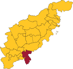
Cleley is one of the hundreds of Northamptonshire, located in the south of the county, adjacent to the border with Buckinghamshire. It is bounded to the north-west by Towcester Hundred; to the north by Wymersley; to the east and south by Buckinghamshire; and to the west by a detached part of Greens Norton Hundred. It had a population of 17,492 in 2011.
It comprises the following ancient parishes:
- Alderton
- Ashton
- Cosgrove
- Easton Neston
- Furtho
- Grafton Regis
- Hartwell
- Passenham
- Paulerspury
- Potterspury
- Roade
- Salcey Forest (ex. par.)
- Whittlewood Forest (ex. par.)
- Wicken
| Hundreds of Northamptonshire |
|---|
|
Chipping Warden • Cleley • Corby • Fawsley • Greens Norton • Guilsborough • Hamfordshoe • Higham Ferrers • Huxloe • King's Sutton • Nassaburgh • Navisford • Nobottle Grove • Orlingbury • Polebrook • Rothwell • Spelhoe • Towcester • Willybrook • Wymersley |