Grafton Regis
| Grafton Regis | |
| Northamptonshire | |
|---|---|
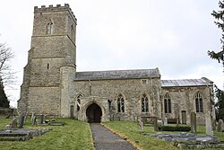
 Church of St Mary, Grafton Regis | |
| Location | |
| Grid reference: | SP7546 |
| Location: | 52°6’52"N, -0°53’47"W |
| Data | |
| Population: | 253 |
| Post town: | Towcester |
| Postcode: | NN12 |
| Dialling code: | 01908 |
| Local Government | |
| Council: | West Northamptonshire |
| Parliamentary constituency: |
Daventry |
Grafton Regis is a village and parish in southern Northamptonshire, adjacent to the border with Buckinghamshire. The population of the civil parish (including the neighbouring parish of Alderton) at the 2001 census was 152. This increased to 253 at the 2011 census.[1] The village is east of the A508 road on which it has a short frontage. It is ca. eight miles south of Northampton and nine miles north of Milton Keynes.
History
The prehistoric site dates back to circa 2500 BC according to Iron Age pottery which was found to the west of the main Northampton Road and to the south of Grafton Lodge which was a Roman site which produced pottery.[2]
A substantial capital messuage stood west of the Church in the Middle Ages. From 1100 to 1348, the manor was in the hands of a Norman monastery whose bailiff or lessee probably occupied the house.[2]
In 1440, the mansion officially became a 'manor house' which belonged to the Woodville family during which time the village was known as Grafton Woodville.[2] The manor was the birthplace of Elizabeth Woodville, queen consort to King Edward IV.[3]
The house and manor passed to the Grey Marquesses of Dorset who were descendants of queen consort Elizabeth Woodville by her first marriage to Sir John Grey.[2] At the end of the 15th century, the house and manor passed to King Henry VIII, grandson of Elizabeth Woodville by Edward IV.[2]
Geography
The ancient parish of Grafton Regis occupied some 1,300 acres on the west bank of the river Tove. The village extends back some distance from the road, albeit at a very low density, towards a church at the eastern edge of the village. Grafton is on the southern ridge of the valley of the River Tove which flows east between the village and Stoke Bruerne to the north and then to the east of the village. Stoke Bruerne church and Stoke Park Pavilions are clearly visible in the distance. The Grand Union Canal passes close by to the east.
Almost all the village on the east side of the A508 is a conservation area.[4]
Buildings
Woodville Manor House appears to have stood on the west side of the A508 road according to excavation in 1964-5. These revealed a mediæval of monastic origin with a cloister and small church. They were converted to secular use in the 15th century. Tiles with the Woodville family arms were discovered in the church.[5]
Another Manor House is on the east side of the A508 road near the parish church. It is the remains of a house built by Henry VIII.[5]
The parish church is dedicated to St Mary and of early 13th-century origin.[5]
References
- ↑ "Civil Parish population 2011". Neighbourhood Statistics. Office for National Statistics. http://www.neighbourhood.statistics.gov.uk/dissemination/LeadKeyFigures.do?a=7&b=11123827&c=Grafton+Regis&d=16&e=62&g=6452355&i=1001x1003x1032x1004&m=0&r=1&s=1467024353584&enc=1. Retrieved 27 June 2016.
- ↑ 2.0 2.1 2.2 2.3 2.4 'Grafton Regis', A History of the County of Northampton: Volume 5: The Hundred of Cleley (2002), pp. 142-176. URL: http://www.british-history.ac.uk/report.aspx?compid=22784 Date accessed: 17 June 2013.
- ↑ Oxford Dictionary of National Biography, accessed 8 January 2010
- ↑ Map of the village showing the conservation area, accessed 17 June 2012
- ↑ 5.0 5.1 5.2 Pevsner, Nikolaus; Cherry, Bridget (revision) (1961). The Buildings of England – Northamptonshire. London and New Haven: Yale University Press. pp. 226–7. ISBN 978-0-300-09632-3.
Outside links
| ("Wikimedia Commons" has material about Grafton Regis) |