Difference between revisions of "Achvaich"
From Wikishire
(Created page with "{{Infobox town |name=Achvaich |gaelic=Achadh a' Bhàthaich |county=Sutherland |picture=Travelling along Strath towards Achvaich - geograph.org.uk - 1047845.jpg |picture captio...") |
|||
| Line 4: | Line 4: | ||
|county=Sutherland | |county=Sutherland | ||
|picture=Travelling along Strath towards Achvaich - geograph.org.uk - 1047845.jpg | |picture=Travelling along Strath towards Achvaich - geograph.org.uk - 1047845.jpg | ||
| − | |picture caption=Approaching | + | |picture caption=Approaching Achvaich along the strath |
|os grid ref=NH712943 | |os grid ref=NH712943 | ||
|latitude=57.92011 | |latitude=57.92011 | ||
| Line 19: | Line 19: | ||
The wee town of [[Dornoch]], on the coast, is almost six miles to the south-east of Achvaich. | The wee town of [[Dornoch]], on the coast, is almost six miles to the south-east of Achvaich. | ||
| + | {{commons}} | ||
==References== | ==References== | ||
{{reflist}} | {{reflist}} | ||
Latest revision as of 22:29, 14 February 2019
| Achvaich Gaelic: Achadh a' Bhàthaich | |
| Sutherland | |
|---|---|
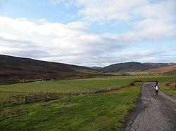
 Approaching Achvaich along the strath | |
| Location | |
| Grid reference: | NH712943 |
| Location: | 57°55’12"N, 4°10’28"W |
| Data | |
| Postcode: | IV25 3 |
| Local Government | |
| Council: | Highland |
| Parliamentary constituency: |
Caithness, Sutherland and Easter Ross |
Achvaich is a remote crofting settlement in the Dornoch area of Sutherland. It is found in the hills, on the north bank of the River Evelix, almost four miles north of the Dornoch Firth at the end of a dead-end road leading up the glen of the Evelix from Sutherland's east coast road.
The wee town of Dornoch, on the coast, is almost six miles to the south-east of Achvaich.
| ("Wikimedia Commons" has material about Achvaich) |