Beacon Way: Difference between revisions
Jump to navigation
Jump to search
Created page with "right|thumb|300px|On the top of Barr Beacon {{county|Staffordshire}} The '''Beacon Way''' is a walking route of around 25 mi..." |
mNo edit summary |
||
| Line 1: | Line 1: | ||
[[File:Barr Beacon - geograph.org.uk - 15079.jpg|right|thumb|300px|On the top of Barr Beacon]] | [[File:Barr Beacon - geograph.org.uk - 15079.jpg|right|thumb|300px|On the top of Barr Beacon]] | ||
{{county|Staffordshire}} | {{county|Staffordshire}} | ||
The '''Beacon Way''' is a walking route of around 25 miles running through [[Staffordshire]]. It takes its name from [[Barr Beacon]], a hill to the east of [[Walsall]], the highest point on the trail and, at 745 feet , one of the highest points in the area. | The '''Beacon Way''' is a walking route of around 25 miles running through [[Staffordshire]]. It takes its name from [[Barr Beacon]], a hill to the east of [[Walsall]], the highest point on the trail and, at 745 feet, one of the highest points in the area. | ||
The trailheads are in: | The trailheads are in: | ||
*Sandwell Park Farm, [[West Bromwich]] ({{wmap|52.5199|-1.9743|zoom=14}} | *Sandwell Park Farm, [[West Bromwich]] ({{wmap|52.5199|-1.9743|zoom=14}}) | ||
*[[Gentleshaw]] ({{wmap|52.7039|-1.9258|zoom=14}} | *[[Gentleshaw]] ({{wmap|52.7039|-1.9258|zoom=14}}) | ||
The Beacon Way starts at Sandwell Park Farm in Sandwell Valley Country Park and extends as far as [[Gentleshaw Common]] where it connects with the [[Heart of England Way]]. | The Beacon Way starts at Sandwell Park Farm in Sandwell Valley Country Park and extends as far as [[Gentleshaw Common]] where it connects with the [[Heart of England Way]]. | ||
| Line 11: | Line 11: | ||
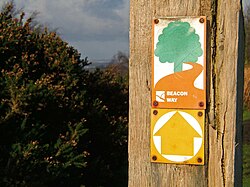
[[File:Beacon Way.jpg|right|thumb|200px|A Beacon Way signpost]] | [[File:Beacon Way.jpg|right|thumb|200px|A Beacon Way signpost]] | ||
==Outside links== | ==Outside links== | ||
*[https://www.ldwa.org.uk/ldp/members/show_path.php?menu_type=S&path_name=Beacon+Way The | *[https://www.ldwa.org.uk/ldp/members/show_path.php?menu_type=S&path_name=Beacon+Way The Beacon Way] - Long Distance Walkers' Association | ||
*[http://www.heartofenglandway.org Heart of England Way Association] | *[http://www.heartofenglandway.org Heart of England Way Association] | ||
[[Category:Footpaths in Staffordshire]] | [[Category:Footpaths in Staffordshire]] | ||
Latest revision as of 16:45, 7 October 2017

The Beacon Way is a walking route of around 25 miles running through Staffordshire. It takes its name from Barr Beacon, a hill to the east of Walsall, the highest point on the trail and, at 745 feet, one of the highest points in the area.
The trailheads are in:
- Sandwell Park Farm, West Bromwich (52°31’12"N, 1°58’27"W)
- Gentleshaw (52°42’14"N, 1°55’33"W)
The Beacon Way starts at Sandwell Park Farm in Sandwell Valley Country Park and extends as far as Gentleshaw Common where it connects with the Heart of England Way.

Outside links
- The Beacon Way - Long Distance Walkers' Association
- Heart of England Way Association