Southern Ocean: Difference between revisions
Created page with "right|thumb|300px|Penguin swimming off Graham Land File:The Southern Ocean and Antarctica.svg|th..." |
|||
| (One intermediate revision by the same user not shown) | |||
| Line 101: | Line 101: | ||
Sailors know latitudes from 40th to the 70th parallel south as the "Roaring Forties", "Furious Fifties" and "Shrieking Sixties" due to high winds and large waves that form as winds blow around the entire globe unimpeded by any land-mass. Icebergs, especially in May to October, makes the area even more dangerous. The remoteness of the region makes sources of search and rescue scarce. | Sailors know latitudes from 40th to the 70th parallel south as the "Roaring Forties", "Furious Fifties" and "Shrieking Sixties" due to high winds and large waves that form as winds blow around the entire globe unimpeded by any land-mass. Icebergs, especially in May to October, makes the area even more dangerous. The remoteness of the region makes sources of search and rescue scarce. | ||
[[File:Antarctic Circumpolar Current.jpg|right|thumb|220px|The Antarctic Circumpolar Current (ACC) is the strongest current system in the world oceans, linking the Atlantic, Indian and Pacific basins.]] | [[File:Antarctic Circumpolar Current.jpg|right|thumb|220px|The Antarctic Circumpolar Current (ACC) is the strongest current system in the world oceans, linking the Atlantic, Indian and Pacific basins.]] | ||
===Antarctic Circumpolar Current and Antarctic Convergence=== | ===Antarctic Circumpolar Current and Antarctic Convergence=== | ||
The Antarctic Circumpolar Current moves perpetually eastward — chasing and joining itself, and at {{convert|21,000|km|mi|-2|x}} in length — it comprises the world's longest ocean current, transporting | The Antarctic Circumpolar Current moves perpetually eastward — chasing and joining itself, and at {{convert|21,000|km|mi|-2|x}} in length — it comprises the world's longest ocean current, transporting 4.6 x 10<sup>9</sup> cubic feet of water a second – 100 times the flow of all the world's rivers. | ||
Several processes operate along the coast of Antarctica to produce, in the Southern Ocean, types of water masses not produced elsewhere in the oceans of the Southern Hemisphere. One of these is the Antarctic Bottom Water, a very cold, highly saline, dense water that forms under sea ice. | Several processes operate along the coast of Antarctica to produce, in the Southern Ocean, types of water masses not produced elsewhere in the oceans of the Southern Hemisphere. One of these is the Antarctic Bottom Water, a very cold, highly saline, dense water that forms under sea ice. | ||
| Line 126: | Line 125: | ||
[[File:Wonder albat.jpg|right|thumb|200px|A Wandering Albatross (''Diomedea exulans'') on South Georgia]] | [[File:Wonder albat.jpg|right|thumb|200px|A Wandering Albatross (''Diomedea exulans'') on South Georgia]] | ||
==Ports and | ==Ports and harbours== | ||
Few ports or harbours exist on the southern (Antarctic) coast of the Southern Ocean, since ice conditions limit use of most shores to short periods in midsummer; even then some require icebreaker escort for access. Most Antarctic ports are operated by government research stations and, except in an emergency, remain closed to commercial or private vessels; vessels in any port south of 60 degrees south are subject to inspection by Antarctic Treaty observers. | Few ports or harbours exist on the southern (Antarctic) coast of the Southern Ocean, since ice conditions limit use of most shores to short periods in midsummer; even then some require icebreaker escort for access. Most Antarctic ports are operated by government research stations and, except in an emergency, remain closed to commercial or private vessels; vessels in any port south of 60 degrees south are subject to inspection by Antarctic Treaty observers. | ||
The major British station is [[Rothera|Rothera Station]] on [[ | The major British station is [[Rothera|Rothera Station]] on [[Adelaide Island]]. This and other British bases are operated for the Crown by the [[British Antarctic Survey]]. Administration is carried out in [[Cambridge]] and the [[Falkland Islands]]. | ||
==Outside links== | ==Outside links== | ||
Latest revision as of 22:05, 10 February 2015


The Southern Ocean (also known as the Great Southern Ocean, Antarctic Ocean, South Polar Ocean, and Austral Ocean) comprises the southernmost waters of the oceans of the world. The Southern Ocean has the unique distinction of being a large circumpolar body of water totally encircling the continent of Antarctica through 360° of longitude. It is regarded as the fourth-largest of the five principal oceans (after the Pacific, Atlantic, and Indian Oceans, but larger than the Arctic Ocean).
On the southern shores of this ocean is the continent of Antarctica, and its greatest peninsula, Graham Land; part of the British Antarctic Territory. Many islands lie within the ocean, most in the British Antarctic Territory; the South Shetland Islands, the South Orkney Islands and the many archipelagos which lie off the coast of Graham Land and Palmer Land. The South Sandwich Islands and South Georgia arguable lie within or at the edge of the Southern Ocean.
The Scotia Sea, between South Georgia and the South Sandwich Islands and Graham Land, and the Weddell Sea, which forms a continental bay between Graham Land, Coats Land and Queen Elizabeth Land, are subsidiary seas within this ocean.
Extent
Geographers disagree on the Southern Ocean's northern boundary, and some even its existence—considering the waters part of the Pacific, Atlantic, and Indian Oceans instead. Some set its northern boundary strictly at the latitude 60° South. Others regard the Antarctic Convergence, a distinctive ocean zone which fluctuates seasonally, as separating the Southern Ocean from other oceans.[1] Australian authorities regard the Southern Ocean as lying immediately south of Australia.[2][3]
History of exploration
The unknown southern land
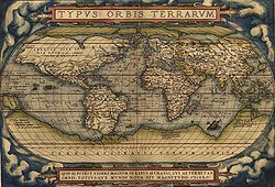
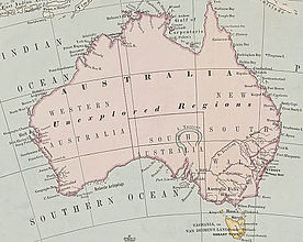
Exploration of the Southern Ocean was inspired by a belief in the existence of a Terra Australis—a vast continent in the far south of the globe to "balance" the northern lands of Europe, Asia and North Africa—which idea had existed since the times of Ptolemy. The idea was eventually disproven but it drove many British voyages of exploration, most famously by Captain James Cook.
Francis Drake discovered the open sea channel south of Tierra del Fuego, which is now named after him, and so he was the first captain to enter the Southern Ocean, if defined to include the Drake Passage, but he sailed no further south into the Southern Ocean.
South of the Convergence
The first voyage south of the Convergence was made by the London mechant Anthony de la Roché in 1675. Having been blown south by a storm on Cape Horn, he appears to have discovered and landed on South Georgia, which was therefore was the first ever discovery of land south of the Antarctic Convergence.[4][5] Soon after the voyage cartographers started to depict 'Roché Island', without knowing where it lay. James Cook was aware of la Roché's discovery when he rediscovered South Georgia in 1775 and proceeded to claim it, name it and survey it.[6]
Edmond Halley's voyage in HMS Paramour for magnetic investigations in the South Atlantic met the pack ice in 52° S in January 1700, but that latitude (he reached 140 miles off the north coast of South Georgia) was his farthest south. A determined effort on the part of the French naval officer Jean-Baptiste Charles Bouvet de Lozier to discover the "South Land" – described by a half legendary "sieur de Gonneyville" – resulted in the discovery of Bouvet Island in 54°10′ S, and in the navigation of 48° of longitude of ice-cumbered sea nearly in 55° S in 1730.
In 1771, Yves Joseph Kerguelen sailed under orders to find Terra Australis Ingognito and at 50° S came to the island which now bears his name, though he called it 'South France' and Cook dubbed it "Desolation Island".
South of the Antarctic Circle
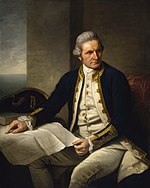
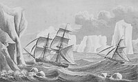
In 1772, James Cook sailed south in the Resolution and the Adventure he followed latitude 58° S, and then further south, on 60th parallel, a lower southern latitude than had ever been voluntarily entered before by any vessel. On 17 January 1773 the ships crossed the Antarctic Circle for the first time in history and in due course reached 67°15’0"S, 39°34’60"E, where their course was stopped by ice.
Cook then turned northward to look for Kerguelen before turning south. He continued eastward nearly on the 60°S to 147°E, until winter approached and he siled for New Zealand. In November 1773, Cook resumed the exploration of the Southern Ocean, proving beyond doubt that the “Unknown South Land” as portrayed on maps, did not exist. In November 1774, Cook started from New Zealand again and crossed the South Pacific to Tierra del Fuego, rounded the Horn and on 29 December, he discovered an island he named the 'Isle of Georgia'; now known as South Georgia, and went on to discover “Sandwich Land” (the South Sandwich Islands). Cook's most southerly discovery of land lay on the temperate side of the 60th parallel and he demonstrated to his satisfaction that if any land lay farther south it was practically inaccessible and without economic value.
In a voyage from 1822 to 1824, the American sealing captain James Weddell sailed the 160-ton brig Jane, accompanied by his second ship Beaufoy, to the South Orkneys, and when sealing proved disappointing they turned south, on 20 February 1823 reaching 74°15’0"S, 34°16’45"W; the southernmost position any ship had ever reached up to that time. No land was sighted, and Weddell decided to turn back.[7]
First sighting of land
The first land south of the 60° south latitude was discovered by the British captain William Smith, who sighted Livingston Island on 19 February 1819. A few months later Smith returned to explore the other islands of the South Shetlands archipelago, landed on King George Island, and claimed the new territories for the King.
The first confirmed sighting of mainland Antarctica is uncertain but may have been by be one of three candidates, who all sighted the ice shelf or the continent within days or months of each other:
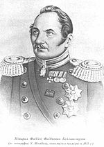
- Fabian Gottlieb von Bellingshausen, a captain in the Russian Imperial Navy;
- Edward Bransfield, a captain in the Royal Navy;
- Nathaniel Palmer, an American sealer
Bellingshausen, retracing Cook’s steps to South Georgia, approached what is now known as the Princess Martha Coast (now in the Norwegian Antarctic Territory) and recorded the sight of an ice shelf. Captain Bransfield on 30 January 1820 sighted the Trinity Peninsula, the northernmost point of the Antarctic mainland in [[[Graham Land]]. Palmer sighted the mainland in the area south of Trinity Peninsula in November 1820.
British Antarctic expeditions in the Southern Ocean
James Clark Ross passed through what is now known as the Ross Sea and discovered Ross Island (both of which were named for him) in 1841. He sailed along a huge wall of ice that was later named the Ross Ice Shelf. Mount Erebus and Mount Terror are named after two ships from his expedition.

The Imperial Trans-Antarctic Expedition of 1914, led by Ernest Shackleton, set out to cross the continent via the pole, but their ship, the Endurance, was trapped and crushed by pack ice before they even landed. The expedition members survived after an epic journey along the edge of the Weddell Sea on sledges over pack ice eventually to Elephant Island. Then Shackleton and five others crossed the Southern Ocean, in an open boat called James Caird, and then trekked over South Georgia to seek help to rescue the expedition.
Shakleton's other party, tasked with laying supplies for the expedition when it passed the South Pole, was also lost by ice in the Southern Ocean.
Recent history
The Antarctic Treaty was signed on 1 December 1959 and came into force on 23 June 1961. Among other provisions, this treaty limits military activity in the Antarctic to the support of scientific research.
The first person to sail single-handed to Antarctica was the New Zealander David Henry Lewis, in 1972, in a 10-metre steel sloop Ice Bird.
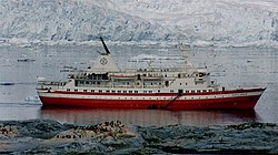
The MS Explorer was a cruise ship operated by the Swedish explorer Lars-Eric Lindblad. Observers point to the Explorer's 1969 expeditionary cruise to Antarctica as the frontrunner for today's sea-based tourism in that region.[8][9] The Explorer was the first cruise ship used specifically to sail the icy waters of the Southern Ocean and the first to sink there[10] when off the British Antarctic Territory she struck an unidentified submerged object on 23 November 2007, reported to be ice, which caused a 10 inch gash in the hull.[11] The Explorer was abandoned in the early hours of 23 November 2007 after taking on water near the South Shetland Islands in the Southern Ocean, an area which is usually stormy but was calm at the time,[12] and sank.
Natural hazards
Icebergs can occur at any time of year throughout the ocean. Some may have drafts up to several hundred meters; smaller icebergs, iceberg fragments and sea-ice a foot to three feet thick) also pose problems for ships. The deep continental shelf has a floor of glacial deposits varying widely over short distances.
Sailors know latitudes from 40th to the 70th parallel south as the "Roaring Forties", "Furious Fifties" and "Shrieking Sixties" due to high winds and large waves that form as winds blow around the entire globe unimpeded by any land-mass. Icebergs, especially in May to October, makes the area even more dangerous. The remoteness of the region makes sources of search and rescue scarce.
Antarctic Circumpolar Current and Antarctic Convergence
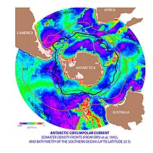
The Antarctic Circumpolar Current moves perpetually eastward — chasing and joining itself, and at 13,000 miles in length — it comprises the world's longest ocean current, transporting 4.6 x 10⁹ cubic feet of water a second – 100 times the flow of all the world's rivers.
Several processes operate along the coast of Antarctica to produce, in the Southern Ocean, types of water masses not produced elsewhere in the oceans of the Southern Hemisphere. One of these is the Antarctic Bottom Water, a very cold, highly saline, dense water that forms under sea ice.
Associated with the Circumpolar Current is the Antarctic Convergence encircling Antarctica, where cold northward-flowing Antarctic waters meet the relatively warmer waters of the subantarctic, Antarctic waters predominantly sink beneath subantarctic waters, while associated zones of mixing and upwelling create a zone very high in nutrients. These nurture high levels of phytoplankton with associated copepods and Antarctic krill, and resultant foodchains supporting fish, whales, seals, penguins, albatrosses and a wealth of other species.[13]
The Antarctic Convergence is considered to be the best natural definition of the northern extent of the Southern Ocean.
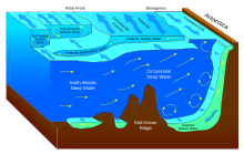
The Weddell Gyreis a gyrewhich swirls round the Weddell Sea (another, in the Ross Sea, is the Ross Gyre). It rotates clockwise, formed by interactions between the Antarctic Circumpolar Current and the Antarctic Continental Shelf.
Biodiversity

Animals
A variety of marine animals exist and rely, directly or indirectly, on the phytoplankton in the Southern Ocean. Antarctic sea life includes penguins, blue whales, killer whales, colossal squids and fur seals. The emperor penguin is the only penguin that breeds during the winter in Antarctica. The rockhopper penguin has distinctive feathers around the eyes, giving the appearance of elaborate eyelashes. King penguins, chinstrap penguins, and gentoo penguins also breed in the Antarctic, and as far north as the Falkland Islands.
The Antarctic fur seal was very heavily hunted in the 18th and 19th centuries for its pelt by sealers from the United States and the United Kingdom. The Weddell seal, a "true seal", is named after Sir James Weddell, commander of British sealing expeditions in the Weddell Sea. Antarctic krill, which congregates in large schools, is the keystone species of the ecosystem of the Southern Ocean, and is an important food organism for whales, seals, leopard seals, fur seals, squid, icefish, penguins, albatrosses and many other birds.[14]
The benthic communities of the seafloor are diverse and dense, with up to 155,000 animals found in 10.8 square feet. As the seafloor environment is very similar all around the Antarctic, hundreds of species can be found all the way around the mainland, which is a uniquely wide distribution for such a large community. Deep-sea gigantism is common among these animals.[15]
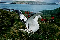
Ports and harbours
Few ports or harbours exist on the southern (Antarctic) coast of the Southern Ocean, since ice conditions limit use of most shores to short periods in midsummer; even then some require icebreaker escort for access. Most Antarctic ports are operated by government research stations and, except in an emergency, remain closed to commercial or private vessels; vessels in any port south of 60 degrees south are subject to inspection by Antarctic Treaty observers.
The major British station is Rothera Station on Adelaide Island. This and other British bases are operated for the Crown by the British Antarctic Survey. Administration is carried out in Cambridge and the Falkland Islands.
Outside links
| ("Wikimedia Commons" has material about Southern Ocean) |
- Oceanography Image of the Day, from the Woods Hole Oceanographic Institution
- The CIA World Factbook's entry on the Southern Ocean
- The Fifth Ocean from Geography.About.com
- The International Bathymetric Chart of the Southern Ocean (IBCSO) National Geophysical Data Center
- U.S. National Oceanic and Atmospheric Administration (NOAA): Limits of Oceans and Seas (2nd Edition), extant 1937 to 1953, with limits of Southern Ocean.
- NOAA In-situ Ocean Data Viewer Plot and download ocean observations
- NOAA FAQ about the number of oceans
- Commission for the Conservation of Antarctic Marine Living Resources
References
- ↑ Pyne, Stephen J.; The Ice: A Journey to Antarctica. University of Washington Press, 1986. (A study of Antarctica's exploration, earth-sciences, icescape, esthetics, literature, and geopolitics)
- ↑ Darby, Andrew (22 December 2003). "Canberra all at sea over position of Southern Ocean". The Age. http://www.theage.com.au/articles/2003/12/21/1071941610556.html. Retrieved 13 January 2013.
- ↑ "Indian Ocean". Encyclopaedia Britannica. http://www.britannica.com/EBchecked/topic/285876/Indian-Ocean. Retrieved 13 January 2013.
- ↑ Dalrymple, Alexander. (1771). A Collection of Voyages Made to the Ocean Between Cape Horn and Cape of Good Hope. Two volumes. London.
- ↑ Headland, Robert K. (1984). The Island of South Georgia, Cambridge University Press. ISBN 0-521-25274-1
- ↑ Cook, James. (1777). A Voyage Towards the South Pole, and Round the World. Performed in His Majesty's Ships the Resolution and Adventure, In the Years 1772, 1773, 1774, and 1775. In which is included, Captain Furneaux's Narrative of his Proceedings in the Adventure during the Separation of the Ships. Volume II. London: Printed for W. Strahan and T. Cadell.
- ↑ Weddel, James (1970) [1825]. A voyage towards the South Pole: performed in the years 1822-24, containing an examination of the Antarctic Sea.. United States Naval Institute. pp. 44, map.
- ↑ "Mar 28 – Hump Day", British Antarctic Survey.
- ↑ Scope of Antarctic Tourism — A Background Presentation, IAATO official website.
- ↑ Reel, Monte (24 November 2007). "Cruise Ship Sinks Off Antarctica". The Washington Post. http://www.washingtonpost.com/wp-dyn/content/story/2007/11/24/ST2007112400367.html. Retrieved 13 May 2010.
- ↑ "154 Rescued From Sinking Ship In Antarctic: Passengers, Crew Boarding Another Ship After Wait In Lifeboats; No Injuries Reported". CBS News. 23 November 2007. http://www.cbsnews.com/stories/2007/11/23/world/main3534814.shtml. Retrieved 2007-11-23.
- ↑ "Doomed Ship Defies Antarctica Odds". Reuters. 25 November 2007. Archived from the original on 2007-11-27. http://web.archive.org/web/20071127153727/http://news.aol.com/story/_a/doomed-ship-defies-antarctica-odds/20071123061209990001?ncid=NWS00010000000001. Retrieved 2007-11-28.
- ↑ "Antarctica Detail". U.S. Department of the Interior, U.S. Geological Survey. 2000-10-18. http://geonames.usgs.gov/apex/f?p=gnispq:5:0::NO::P5_ANTAR_ID:488. Retrieved 2014-01-18.
- ↑ "Creatures of Antarctica". Archived from the original on 14 February 2005. http://web.archive.org/web/20050214015049/http://www.knet.co.za/antarctica/fauna_and_flora.htm. Retrieved 6 February 2006.
- ↑ Australian Antarctic Division. "Seabed (benthic) communities". Government of Australia. Archived from the original on 19 March 2013. http://web.archive.org/web/20130319154433/http://www.antarctica.gov.au/about-antarctica/wildlife/animals/seabed-benthic-communities. Retrieved 8 April 2013.
Further reading
- Gille, Sarah T. 2002. "Warming of the Southern Ocean since the 1950s": abstract, article. Science: vol. 295 (no. 5558), pp. 1275–1277.
- Descriptive Regional Oceanography, P. Tchernia, Pergamon Press, 1980.
- Matthias Tomczak and J. Stuart Godfrey. 2003. Regional Oceanography: an Introduction. (see the site)


