South Pole
The South Pole is one of the two points where the Earth's axis of rotation intersects its surface. It is the southernmost point on the surface of the Earth, since its position is the very definition of "south" and it is the southern vertex point defining the British Antarctic Territory in accordance with the Letters Patent creating it; and thus the South Pole is also the southernmost point of British territory.
When the name 'Queen Elizabeth Land' was given to the southern part of the British Antarctic Territory in 2012, its southernmost point was defined as the South Pole.
The South Pole is in the midst of the continent of Antarctica, on the Antarctic Plateau (first named by its discoverer, Shackleton, the "King Edward VII Plateau") and its antipodes is of course the North Pole. At the South Pole is the United States Amundsen-Scott South Pole Station, established in 1956 and named from the two discovers of the Pole: Captain Robert Falcon Scott and his Norwegian rival, Roald Amundsen.
The pole also known as the Geographic South Pole or Terrestrial South Pole, to distinguish it from other poles, in particular the Magnetic South Pole.
Geography


For most purposes, the Geographic South Pole is defined as the southern point of the two points where the Earth's axis of rotation intersects its surface (the other being the North Pole). However, the Earth's axis of rotation is actually subject to very small 'wobbles', so this definition is not adequate for very precise work.
The geographic coordinates of the South Pole are usually given simply as 90°S, since its longitude is geometrically undefined and irrelevant. When a longitude is desired, it may conventionally be given as 0°. At the South Pole all directions face north. For this reason, directions at the Pole are given relative to "grid north", which points northwards along the prime meridian.[1]
Antarctic Plateau
The Antarctic Plateau (sometimes referred to as the Polar Plateau) is a large area of Central Antarctica, which extends over a diameter of about 620 miles, and which includes the region of the South Pole. The plateau's average elevation (on top of the ice) is about 10,000 feet.
The first men to set eyes on the plateau were a party led by Robert Falcon Scott in 1903, during the Discovery Expedition. The first to cross part of the plateau was Ernest Shackleton in 1909, during his Nimrod Expedition. He hoped to reach the South Pole itself but was driven back by bad weather when it had reached a point just 97 nautical miles from the South Pole. Shackleton named the plateau the King Edward VII Plateau in honour of the King. Just two years later (in late 1911), the Norwegian explorer Roald Amundsen decided to name this plateau the Haakon VII Plateau in honour of the newly crowned King Haakon VII of Norway, while Amundsen's expedition was returning from his success in reaching the South Pole in December 1911. The name 'Antarctic Plateau' is a descriptive compromise.
The first aerial observation was in 1929 by a four-man team piloted by Bernt Balchen, a Norwegian, with Richard E Byrd of the United States Navy as navigator and chief organizer of the expedition.
Finding the pole

The Geographic South Pole is located on the Antarctic Plateau on the continent of Antarctica, on a featureless, barren, windswept, icy plain at an altitude of 9,301 feet above sea level. The nearest open sea is 800 miles away at the Bay of Whales (at the edge of the Ross Dependency; New Zealand's Antarctic territory). The ice is estimated to be about 9,000 feet thick at the Pole, so the land surface under the ice sheet is actually near sea level.[2]
The polar ice sheet is moving at a rate of roughly 10 yards a year in a direction between 37° and 40° west of grid north,[3] down towards the Weddell Sea. Therefore, the position of the station and other artificial features relative to the geographic pole gradually shifts over time.
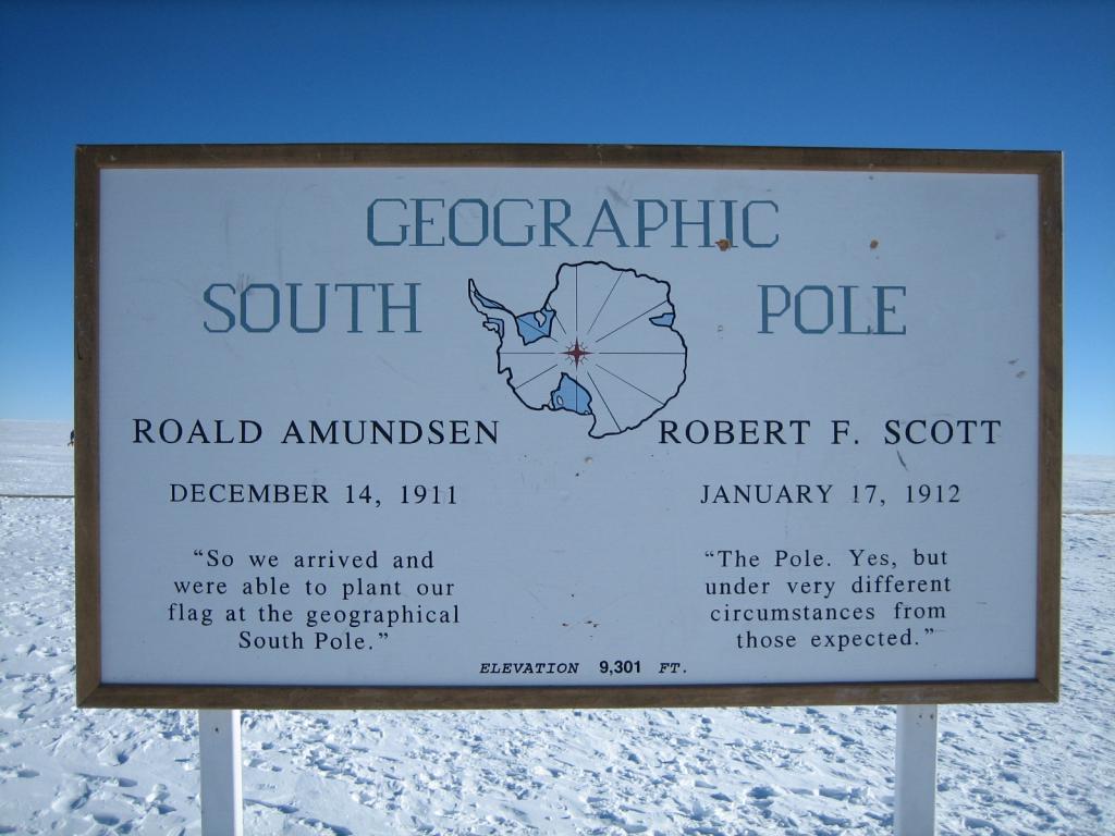
The Geographic South Pole is marked by a ceremony on New Year's Day in which a small sign is moved and a stake is placed in the ice pack, which are positioned each year to compensate for the movement of the ice.[4] The sign records the respective dates that Roald Amundsen and Robert F Scott reached the Pole, followed by a short quotation from each man, and gives the elevation as 9,301 feet.[5][6]
Other 'South Poles'

2. South Magnetic Pole (2007)
3. South Geomagnetic Pole (2005)
4. South Pole of Inaccessibility
The Ceremonial South Pole is an area set aside for photo opportunities at the South Pole Station. It is located a short distance from the Geographic South Pole, and consists of a metallic sphere on a plinth, surrounded by the flags of the Antarctic Treaty signatory states.
The following are listed as "South Poles":
- The South Geographic Pole;
- The South Magnetic Pole: the wandering point in the Southern Hemisphere where the geomagnetic field lines are directed vertically upwards
- The South Geomagnetic Pole: the point where the axis of notional dipole of the Earth' magnetic field intersects with the Earth's surface in the southern hemisphere
- The South Pole of Inaccessibility: the point on the Antarctic continent most distant from the Southern Ocean.
Exploration
Pre-1900
In 1820, several expeditions claimed to have been the first to have sighted Antarctica, with the very first being the Russian expedition led by Fabian Bellingshausen and Mikhail Lazarev. A year later an American sealing Captain, John Davis, claimed to be the first to set foot on the ice.
James Clark Ross, in his expedition of 1839–43, hoped that he might be able to sail all the way to the South Pole but discovered the impossibility of doing so.[7]
1900–1950

The first attempt to find a route from the Antarctic coastline to the South Pole was made by British explorer Robert Falcon Scott on the Discovery Expedition of 1901–04. Scott, accompanied by Ernest Shackleton and Edward Wilson, set out with the aim of travelling as far south as possible, and on 31 December 1902, reached 82°16′ S.[8]
In 1908, Letters Patent were issued annexing the lands of Antarctica south of the Falkland Islands as part of the Falkland Islands Dependencies (later the British Antarctic Territory) That year Shackleton returned to the newly claimed territory as leader of the British Antarctic Expedition (the Nimrod Expedition) in a bid to reach the Pole. On 9 January 1909, with three companions, he reached 88°23′ S – 112 statute miles from the Pole – before being forced to turn back.[9]
In 1911, Scott set out once again, with the Terra Nova but unbeknownst to him, Raoul Amundsen had also sailed south on the Fram, Nansen's ship. Scott moored the Discovery at Cape Evans, and soon afterwards Amundsen moored the Fram in the Bay of Whales; both on the Ross Ice Shelf. In the event, the Norwegians reached the South Pole first, on 14 December 1911. Amundsen named his camp Polheim and the entire plateau surrounding the Pole King Haakon VII Vidde. Scott and four other men reached the South Pole on 17 January 1912, thirty-four days after Amundsen, and his diary records the despair he felt at discovering the Norse flag flying at the pole before him. On the return trip, Scott and his four companions all died of starvation and extreme cold.
In 1914 Ernest Shackleton's Imperial Trans-Antarctic Expedition set out with the goal of crossing Antarctica via the South Pole, and moored in the ice of the Ronne Ice Shelf but his ship, the Endurance, was frozen in pack ice and sank 11 months later. The overland journey was never made.
1950–present

After Scott, no one set foot at the South Pole until 1956, when an American party flew theer and landed on the ice. The US Amundsen-Scott South Pole Station was established by air over 1956–1957 for the International Geophysical Year and has been continuously staffed since then by research and support personnel.[2]
The first overland expedition to reach the pole after Scott was led by two famed explorers, Edmund Hillary Vivian Fuchs during the Commonwealth Trans-Antarctic Expedition. In 1987 the Americans established a logistic support base at Patriot Hills, and the South Pole became more accessible to non-government expeditions.
The fastest unsupported journey to the Geographic South Pole from the ocean is 24 days and one hour from Hercules Inlet and was set in 2011 by Norwegian adventurer Christian Eide,[10] who beat the previous solo record set in 2009 by American Todd Carmichael of 39 days and seven hours, and the previous group record also set in 2009 of 33 days and 23 hours.[11]
In the 2011/12 summer, separate expeditions by Norwegian Aleksander Gamme and Australians James Castrission and Justin Jones jointly claimed the first unsupported trek without dogs or kites from the Antarctic coast to the South Pole and back. The two expeditions started from Hercules Inlet a day apart and completed the last few miles together. [12][13][14]
Time
In most places on Earth, local time is determined by longitude, so that, broadly, the sun is at its zenith at 12 noon in the relevant time zone. However all the longitudes and all the time zones meet at the pole, and there is no zenith; the Sun circles above the horizon in summer and in winter never rises above it. Since the only people living at the pole are at the Amundsen-Scott South Pole Station, local time is that chosen by the station, which happens to be New Zealand time as its resupply missions are flown from Christchurch in New Zealand.
Flora and fauna
Due to its exceptionally harsh climate, there are no native resident plants or animals at the South Pole. Remarkably, though, off-course skuas and snow petrels are occasionally seen there.[15]
In 2000 it was reported that microbes had been detected living in the South Pole ice, though scientists think it is unlikely that they evolved in Antarctica.[16]
See also
Outside links
| ("Wikimedia Commons" has material about South Pole) |
- NOAA South Pole Webcam
- 360° Panoramas of the South Pole
- Images of this location are available at the Degree Confluence Project
- South Pole Photo Gallery
- Poles by the Australian Antarctic Division
- The Antarctic Sun - Online news source for the U.S. Antarctic Program
- Big Dead Place
- UK team makes polar trek history - BBC News article on first expedition to Pole of Inaccessibility without mechanical assistance
- Listen to Ernest Shackleton describing his 1908 South Pole Expedition, and read more about the recording on [australianscreen online].
References
- ↑ "Moving the South Pole", NASA Quest
- ↑ 2.0 2.1 Amundsen-Scott South Pole Station, National Science Foundation, Office of Polar Programs
- ↑ "Where is the real Pole really?". http://www.southpolestation.com/pole/survey.html. Retrieved 2008-03-25.
- ↑ "Marker makes annual move", Antarctic Sun. January 8, 2006; McMurdo Station, Antarctica.
- ↑ "Sign at the (ever moving) actual geographical South Pole (a few feet away from the Ceremonial Pole)". Pierre R. Schwob Physics/Astronomy. http://www.classicalarchives.com/prs/astro/Antarctica/0640-Sign_at_the__moving__actual_geographical_South_Pole.jpg. Retrieved 2013-05-25.
- ↑ Kiefer, Alex (January 1994). "South Pole Marker". http://www.trekearth.com/gallery/photo284509.htm. Retrieved 2008-03-24.
- ↑ Science into Policy: Global Lessons from Antarctica, p. 35, Paul Arthur Berkman, 2002
- ↑ Science into Policy: Global Lessons from Antarctica, p. 37, Paul Arthur Berkman, 2002
- ↑ Antarctica, p. 24, Paul Simpson-Housley, 1992
- ↑ Explorersweb (2011-01-13). "Breaking news: Christian Eide bags the South Pole solo speed ski world record". explorersweb.com. http://www.explorersweb.com/polar/news.php?id=19887. Retrieved 2011-01-13.
- ↑ The Canadian Press (2009-01-07). "Canadians break speed record trekking to South Pole". thestar.com. http://www.thestar.com/News/Canada/article/563312. Retrieved 2010-02-10.
- ↑ "Ice Trek Expeditions". http://www.icetrek.com/?id=432. Retrieved 2013-05-25.
- ↑ "Crossing the Ice". http://casandjonesy.com.au/expeditions/crossing-the-ice/. Retrieved 2013-05-25.
- ↑ "Wilson, nå er vi framme!". http://gamme.no/x-blogg/entry/antarktis-2011-2012/wilsonnaerviframme. Retrieved 2013-05-25.
- ↑ Mark Sabbatini, "Non-human life form seen at Pole", The Antarctic Sun, 5 January 2003.
- ↑ "Snow microbes found at South Pole", BBC News, 10 July 2000
- The recording describing Shackleton's 1908 South Pole Expedition was added to the National Film and Sound Archive's Sounds of Australia registry in 2007