Whitley, Yorkshire
| Whitley | |
| Yorkshire West Riding | |
|---|---|
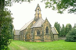
 All Saints Whitley | |
| Location | |
| Grid reference: | SE561212 |
| Location: | 53°41’3"N, 1°9’6"W |
| Data | |
| Population: | 1,021 (2011) |
| Post town: | Goole |
| Postcode: | DN14 |
| Dialling code: | 01977 |
| Local Government | |
| Council: | North Yorkshire |
Whitley is a village in the West Riding of Yorkshire, close to the Aire and Calder Navigation and the M62 motorway. The population of the village at the 2011 Census was recorded as 574.
The village is on the A19 road, south of its intersection with the M62 motorway, six miles west of Snaith and seven miles north-east of Pontefract. The village is served by Whitley Bridge railway station to the north, but only has one train a day eastwards and only two westwards.
History
The village is recorded in the Domesday Book as Witelai,[1] with the name deriving from the Old English hwit leah, meaning White wood clearing.[2]
A manor owned by the Knights Templar is believed to have existed south west of the village between 1248 and 1312. Unlike other Templar possessions which were taken over, when the order was dissolved, Whitley Preceptory was left to ruin.[3]
Outside links
| ("Wikimedia Commons" has material about Whitley, Yorkshire) |
References
- ↑ Whitley, Yorkshire in the Domesday Book
- ↑ Ekwall, Eilert, The Concise Oxford Dictionary of English Place-Names. Oxford, Oxford University Press, 4th edition, 1960. p. 514 ISBN 0198691033
- ↑ National Heritage List 1017458: Whitley Thorpe moated Templar grange site, north west of Fulham House (Scheduled ancient monument entry)