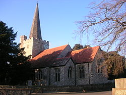
Westbourne, Sussex
| Westbourne | |
| Sussex | |
|---|---|
 St John the Baptist, Westbourne | |
| Location | |
| Grid reference: | SU756074 |
| Location: | 50°51’41"N, -0°55’35"W |
| Data | |
| Population: | 2,309 (2011) |
| Post town: | Emsworth |
| Postcode: | PO10 |
| Dialling code: | 01243 |
| Local Government | |
| Council: | Chichester |
| Parliamentary constituency: |
Chichester |
| Website: | http://www.westbournevillage.org/ |
Westbourne is a village in Sussex, in the very south-west of the county, half mile north-east of Emsworth, the latter across the border in Hampshire. The parish includes the hamlets of Woodmancote and Aldsworth.
The village stands beside the River Ems, a small river flowing into Chichester Harbour at Emsworth. It is believed that the village takes its name from the river, which here marks the westernmost boundary of Sussex:[1] the Ems was originally known as the Bourne, but was renamed by the 16th century chronicler Raphael Holinshed.[2]
The Emille cometh first between Racton and Stansted, then down to Emilswort or Emmesworth, and so into the Ocean, Seperating Sussex from Hampshire.
The parish covers an area of 1,846 acres. The population of the village in 2011 was recorded as 2,309.
History
Westbourne contains 66 listed buildings some dating back to the 16th Century, though written evidence of habitation can be found in the Domesday Book of 1086.[3][4]
The parish church, St John the Baptist, is mediæval and is notable for its fine yew avenue, which is apparently the oldest in Britain, and walled graveyard. Nicholas Levett, a native of Petworth and fellow of Balliol College, Oxford, was long-time minister of St John the Baptist. He was buried in Beckley, Oxfordshire, in 1687.[5]
About the village
Commonside forms the northern edge of the village of Westbourne. This area is centred on a village pub called the Cricketers which is located near the village cricket pitch. There are two other public houses, the White Horse and the Stag's Head, both in The Square, at the centre of the oldest part of the village. Until 2010, a third pub called the Good Intent was open in North Street, but this has now closed and has been converted to a private home.
As of April 2011, the north-eastern and eastern edges of the village now form boundaries with the newly designated South Downs National Park.
Outside links
| ("Wikimedia Commons" has material about Westbourne, Sussex) |
References
- ↑ About Westbourne - Westbourne Village Website
- ↑ Reger, A J C (1967). A Short History of Emsworth and Warblington. Portsmouth: Pott and Horsey.
- ↑ National Archives Record from the Domesday Book
- ↑ Westbourne, Sussex in the Domesday Book
- ↑ Alumni Oxoniensis: The Members of the University of Oxford, 1500-1714 : Their Parentage, Birthplace, and Year of Birth, with a Record of Their Degrees: Being the Matriculation Register of the University, University of Oxford, Joseph Foster, University of Oxford, Published by Parker, 1891
Books
- Roch, Lucinda and Toms, Matthew: 'The Westbourne Story' (Emsworth: Kenneth Mason Publications, 2005) p. 192, ISBN 0-85937-404-1