Thurstonland
| Thurstonland | |
| Yorkshire West Riding | |
|---|---|
 Thurstonland | |
| Location | |
| Grid reference: | SE166104 |
| Location: | 53°35’24"N, 1°45’0"W |
| Data | |
| Post town: | Huddersfield |
| Postcode: | HD4 |
| Dialling code: | 01484 |
| Local Government | |
| Council: | Kirklees |
| Parliamentary constituency: |
Huddersfield |
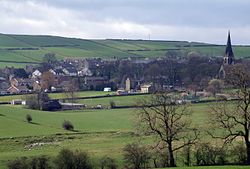
Thurstonland is a village in the West Riding of Yorkshire, with a population of almost 400.
The village is on a hilltop above Brockholes, south-east of Farnley Tyas and north of Shepley. It is a few miles outside the borders of the Peak District National Park.
The village has a church, a public house, a school, church, children's recreational area and cricket club. Apart from the pub on the southern edge of the village the other facilities are all located next to each other, at the northern edge.
Through the hill is driven the Thurstonland Tunnel on the Penistone railway line, between Brockholes railway station and Stocksmoor railway station.
Within and around the village are a number of small dairy farms that supply the surrounding area.
History
The village appears as Tostenland in the Domesday Book of 1086. The Wakefield court rolls indicate the village was a township in 1275, when 'Storthes in Thurstonland' is mentioned and 'Matthew de Storthes', in the reign of Henry III (1216 to 1272) lived in the area. In 1541 Henry VIII granted "to John Storthes of Shitlington, but likewise of Storthes Hall, gentleman" the manor of Thurstonland and other lands that had been the property of Roche Abbey.
Storthes Hall, on the northern boundary of the township, was the location of a family mansion. It is now the site of a residential campus for the University of Huddersfield.
In 1921 the parish had a population of 2,488.[1]

Sport
- Cricket: Thurstonland CC, founded in 1874. The club's Edwardian-style wooden pavilion was built in 1910.
Outside links
| ("Wikimedia Commons" has material about Thurstonland) |
References
- ↑ "Population statistics Thurstonland Tn/CP through time". A Vision of Britain through Time. https://visionofbritain.org.uk/unit/10472131/cube/TOT_POP. Retrieved 11 August 2023.