Thurlby by Bourne
| Thurlby | |
| Lincolnshire | |
|---|---|
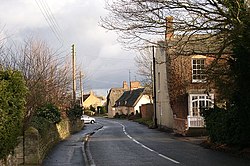
 Thurlby village | |
| Location | |
| Grid reference: | TF095168 |
| Location: | 52°44’18"N, 0°22’43"W |
| Data | |
| Population: | 2,153 (2011) |
| Post town: | Bourne |
| Postcode: | PE10 |
| Local Government | |
| Council: | South Kesteven |
| Parliamentary constituency: |
Grantham and Stamford |
Thurlby is a village in Lincolnshire, in the south of the county, within Kesteven: Kesteven has another Thurlby also, further north, and for this reason, the village is also known as Thurlby by Bourne.
The village is found just west of the A15 road, two miles south from the town of Bourne, and on the edge of the Lincolnshire Fens.
Thurlby and the hamlet of Northorpe to its north are conjoined. The parish had a population of 2,136 at the 2001 census, although this had increased to 2,153 at the 2011 census.
History
The Roman Car Dyke passes through the parish to the east of the road. The A15 road itself broadly follows the route of the Roman Road known as King Street.
The church of St Firmin dates back to before the Norman Conquest, reportedly to 925 AD.[1] It has features of Saxo-Norman and Perpendicular style.[1]
Thurlby is mentioned in the 1086 Domesday Book as "Tvrolvebi",[2] "Tvrodldbi",[3] "Torulfbi"[4] and "Turoluebi".[5]
A Methodist chapel, Trinity Methodist Church, was established in 1912.
Thurlby railway station was on the Bourne and Essendine railway; it opened in 1860 and closed in 1951. The railway workers cottages 3 to 9 Station Road, built in 1866 are nearly the oldest properties in the village, they were famously hit by an air bus in the 1920s.[6]
Geography
Geographically Thurlby is on the western edge of The Lincolnshire Fens, and Thurlby Fen, to the east of the A15, falls within the drainage area of the Welland and Deepings Internal Drainage Board.[7]
Thurlby lies between Bourne and Baston. Most of the village lies to the west of the A15 road but a part, including the parish church, is to the east. The parish includes Northorpe, which is continuous with Thurlby, and the outlying hamlets of Obthorpe and Kate's Bridge. The ecclesiastical parish of Thurlby shares the same boundaries as the civil parish.
Community

The ecclesiastical parish, with a single parish church of St Firmin, is part of the Ness group of parishes.
There is one public house, the Horseshoe, located on the A15 and High Street junction. Thurlby also contains a renovated shop with a post office, and a veterinary practice. A firm of agricultural engineers, a furniture store, and a petrol station operate in Kate's Bridge, about half a mile from the village.
In 1979 local resident Harold Sneath bequeathed his home to the Youth Hostels Association to use as youth hostel]].[8] Following the 2001 foot and mouth crisis]] the Association looked to close the hostel to reduce costs. The local councils were opposed to the closure and bought the building to lease back to Youth Hostels Association. The signpost for Thurlby now shows the YHA logo reflecting the ownership of the hostel.
Sport and leisure
The Thurlby 10 km Road Race and the 3 km Fun Run is organized each year by a group of volunteers, with hundreds of runners taking part. The races are usually held on the first Sunday in July.
Lawrance Park (TF095170) has a community hall, park and children's play area. It is a sporting venue for the village, with many events taking place both in the hall (circuit training, indoor bowls, Taekwondo and line dancing) and games in the park itself.
- Football:
- Thurlby Tigers juniors
- Thurlby United, men's side. Both sides play home fixtures at Lawrance Park.
- Tennis
Car boot sales take place at Lawrance Park twice a year, at the end of March and at the end of September. They regularly attract over a hundred stalls and more than a thousand visitors from across the south of Lincolnshire.
Outside links
| ("Wikimedia Commons" has material about Thurlby by Bourne) |
- Information on Thurlby by Bourne from GENUKI
- Thurlby's entry in the Parliamentary Gazetteer of 1843-4
- Local web site about Thurlby
- Thurlby Village A History of the village of Thurlby and Northorpe and its People
References
- ↑ 1.0 1.1 National Monuments Record: No. 350407 – St Firmin's
- ↑ Phillimore Domesday Book:Lincolnshire, Part 1: landowner 8.4
- ↑ Phillimore Domesday Book:Lincolnshire, Part 1: landowner 8.38
- ↑ Phillimore Domesday Book:Lincolnshire, Part 1: landowner 27.52
- ↑ Phillimore Domesday Book:Lincolnshire, Part 2: landowner 59.8
- ↑ National Monuments Record: No. 507095 – Station site
- ↑ "Welland and Deepings IDB". http://www.wellandidb.org.uk/.
- ↑ Noble p. 136.
- Noble, Majorie, ed (1987). Thurlby: an ordinary village. Bourne: Warners. ISBN 0-9512386-0-4.
- John Morris, Domesday Book Lincolnshire, Phillimore, Chichester, 1986. ISBN 0-850335981.