Teignmouth
| Teignmouth | |
| Devon | |
|---|---|
 Teignmouth | |
| Location | |
| Grid reference: | SX945735 |
| Location: | 50°33’6"N, 3°29’19"W |
| Data | |
| Population: | 14,413 (2001) |
| Post town: | Teignmouth |
| Postcode: | TQ14 |
| Dialling code: | 01626 |
| Local Government | |
| Council: | Teignbridge |
| Parliamentary constituency: |
Teignbridge |
Teignmouth is a fishing port and seaside resort town in western Devon. It stands on the north bank of the broad estuary of the River Teign, at its mouth on the English Channel about 14 miles south of Exeter. It had a population of 14,413 in 2001.
The town grew from a fishing port associated with the Newfoundland cod industry to a seaside resort of some note in Georgian times, with further expansion after the opening of the South Devon Railway in 1846. Today, its port still operates and the town remains a popular seaside holiday location.
History
To 1700

The first record of Teignmouth, Tengemuða, meaning mouth of the stream, was in 1044.[1] Nonetheless settlements very close by are attested earlier, with the banks of the Teign estuary having been in Saxon hands since at least 682, a battle between the Ancient Britons and Saxons being recorded on Haldon in 927, and Danish raids having occurred on the Teign estuary in 1001.
There were originally two villages, East and West Teignmouth, separated by a stream called the Tame, which emptied into the Teign through marshland by the current fish quay.[2] Neither village is mentioned in the Domesday Book, but East Teignmouth was granted a market by charter in 1253 and one for West Teignmouth followed a few years later.[3] The Tame now runs under the town in culverts and is only visible higher up the town as Brimley Brook, joined by smaller streams such as the Winterbourne (an intermittent stream, which flows only in winter or after heavy rain).
Documents indicate that Teignmouth was a significant port by the early 14th century, second in Devon only to Dartmouth.[4] It was attacked by the French in 1340 and sent seven ships and 120 men to the expedition against Calais in 1347.[5] Its relative importance waned during the 15th century, and it did not figure in an official record of 1577. This may have been due to silting up of the harbour caused by tin mining on Dartmoor.[6]
During the 17th century, in common with other Channel ports, Teignmouth ships suffered from raids from Dunkirkers, which operated as privateers from Flemish ports. It is possible that smuggling was the town's most significant trade at this time, though cod fishing in Newfoundland was also of great importance.[7]
In July 1690, after the French Admiral Anne Hilarion de Tourville defeated an Anglo-Dutch fleet at the Battle of Beachy Head, the French fleet was anchored in Torbay and some of the galley fleet travelled the short distance up the coast and attacked Teignmouth. A petition to the Lord Lieutenant from the inhabitants described the incident:
... on the 26th day of this instant July 1690 by Foure of the clocke in the morning, your poor petitioners were invaded (by the French) to the number of 1,000 or thereabouts, who in the space of three hours tyme, burnt down to the ground the dwelling houses of 240 persons of our parish and upwards, plundered and carried away all our goods, defaced our churches, burnt ten of our ships in the harbour, besides fishing boats, netts and other fishing craft ...
After examining 'creditable persons' the Justices of the Peace concluded that:
by the late horrid invasion there were within the space of 12 houres burnt downe and consumed 116 dwelling houses ... and also 172 dwelling houses were rifled and plundered and two parish churches much ruined, plundred and defaced, besides the burning of ten saile of shipps with the furniture thereof, and the goods and merchandise therein ...
As a result, the Crown issued a church brief that authorised the collection of £11,000 for the aid of the town. Churches from as far afield as Yorkshire contributed, and the collections enabled the further development of the port.[8] This was the last time foreign invaders crossed the Channel to invade these shores (though it was not quite the last invasion of all, for in 1797 a rag-tag French force landed in Pembrokeshire, at Carreg Gwastad, near Fishguard before being seen off).
French Street with its museum is named in memory of the grim occasion.
In the 1600s and 1700s there are records of a windmill on the Den - an area that was then a large sand dune, and is now a grassy public open space near the seafront. By 1759 this windmill was demolished.
1700 to present
A new advantageous Plan of Privateering
For a Six Months Cruize
All Gentlemen Seamen and Able Landmen who delight in the Music of Great Guns and distressing the Enemies of Great Britain have now a fine opportunity of making their Fortunes by entering on Board The Dragon Privateer ... now ready to be launch'd in the Harbour of Teignmouth... Any persons capable of beating a Drum or blowing a French horn shall have great encouragement.—Advertisement for the Dragon, 1779.
In the late 18th century, privateering was common in Teignmouth, as it was in other West Country ports. In 1779 the French ship L'Emulation with a cargo of sugar, coffee and cotton was offered for sale at "Rendle's Great Sale Room" in the town. Teignmouth people fitted out two privateers: the Dragon with 16 guns and 70 men; and the Bellona, described as carrying "16 guns, 4 cohorns and 8 swivels".[9] The Bellona set sail on her first voyage in September 1779, and was "oversett in a violent Gust of Wind" off Dawlish with the loss of 25 crew members.[10]
The Newfoundland fisheries continued to provide the main employment into the early 19th century and, fortuitously for the town, as the fisheries declined the prospect of tourism arose. A tea house was built on the Den in 1787 amongst the local fishermen's drying nets. The "Amazons of Shaldon"—muscular women who pulled fishing nets and were "naked to the knee"—were an early tourist attraction for male tourists.[11]
By 1803 Teignmouth was called a "watering place" to be seen in, and the resort continued to develop during the 19th century. Its two churches were rebuilt soon after 1815 and in the 1820s the first bridge across the estuary to Shaldon was built; George Templer's New Quay opened at the port; and the esplanade, Den Crescent and the central Assembly Rooms (later the cinema) were laid out. The railway arrived in 1846 and the pier was built 1865–7.[12]

A version of the legend of the Parson and Clerk dating to 1900 tells the tale of the Bishop of Exeter visiting Teignmouth and whilst being guided by a local priest, the devil turns them both to stone, which is seen in the form of two stacks.[13]
The First World War had a disruptive effect on Teignmouth: over 175 men from the town lost their lives and many businesses did not survive. In the 1920s as the economy started to recover, a golf course opened on Little Haldon; the Morgan Giles shipbuilding business was established, and charabancs took employees and their families for annual outings to Dartmoor and elsewhere. By the 1930s the town was again thriving, and with the Haldon Aerodrome and School of Flying nearby, Teignmouth was advertised as the only south coast resort offering complete aviation facilities.[14]
During the Second World War Teignmouth suffered badly from "tip and run" air raids.[2] It was bombed 21 times between July 1940 and February 1944 and 79 people were killed, 151 wounded, 228 houses were destroyed and over 2,000 damaged in the raids.[15] Teignmouth's hospital was bombed during a raid on 8 May 1941, killing three nurses and seven patients. It was rebuilt and reopened in September 1954, making it the first complete general hospital in the country to be built after the formation of the National Health Service.[16]
A US Navy plan existed which proposed to dam the harbour and set up a seaplane base, but it was abandoned as the war turned in favour of the allies.[17]

The port
The port of Teignmouth, in existence since the 13th century, remains active, mostly handling clay, timber and grain.
The Old Quay was built in the mid-18th century on land leased from Lord Clifford. The opening of the Stover Canal by James Templer in 1792[18] provided a boost to the port due to the ease with which ball clay could be transported from the mines north of Newton Abbot. After travelling along the canal the barges continued down the estuary to the port. By 1820 this trade was supplemented by granite from the quarries near Haytor on Dartmoor carried via the unique granite-tracked Haytor Granite Tramway which was linked to the Stover Canal. The granite to build the new London Bridge came by this route and was sent from the New Quay, which had been built for this traffic in 1821–25 by George Templer, James's son.[19]
The Old Quay was sold to George Hennet in 1850 and became the centre of his trading network. It was connected to the South Devon Railway the previous year.
Until 1852 Teignmouth was legally part of the Port of Exeter. In September of that year, after many years of campaigning (latterly under the leadership of George Hennet), the Lords Commissioners of the Treasury agreed that Teignmouth should be independent which was the cause of much celebration.[20]
Teignmouth has a tradition of shipbuilding from the 17th century. By the turn of the 19th century there were three shipyards in Teignmouth, and three in Shaldon and Ringmore on the opposite side of the estuary.[21] The industry declined in the early 20th century, but in 1921 Morgan Giles bought the last derelict shipbuilding yard and gave the industry a new stimulus. His shipyard became a major employer, building pleasure craft in peacetime and small craft such as torpedo boats during Second World War. The business failed in 1968 not long after Donald Crowhurst's attempt to sail around the world.[22]
The Shipwrecked Fishermen and Mariners' Royal Benevolent Society sent a lifeboat to Teignmouth in 1851 and kept it in a boathouse on the beach near the Custom House. In 1854 the society transferred its lifeboats to the Royal National Lifeboat Institution (RNLI). A new boathouse was provided on The Den with doors facing the harbour which was used until 1940. After a gap of fifty years, on 3 November 1990, the RNLI reopened Teignmouth Lifeboat Station with an Atlantic 21 inshore lifeboat.[23]
-

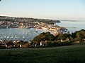
Teignmouth Harbour from New Quay -
Teignmouth Harbour from Shaldon -

Teignmouth from Shaldon River Beach -
 Shaldon Bridge


Shaldon Bridge

The Shaldon Bridge crosses the Teign Estuary at Teignmouth, carrying the railway and the road. The original bridge was owned by the Teignmouth and Shaldon Bridge Company and opened on 8 June 1827.[24] It had 34 wooden arches and was 1,671 feet long, which made it the longest wooden bridge in Britain when built. It had abutment walls of a considerable length at either end, and a swing bridge at the Teignmouth end to allow sailing ships to pass up the estuary.[25] It cost around £19,000 to build, but the overall expenditure was about £26,000 due to the costs of the necessary Act of Parliament and the purchase of the old ferry-rights.[26] Toll houses were built at each end of the bridge, and the one on the Teignmouth side survives.[27]
After eleven years, on 27 June 1838 the centre arches of the bridge collapsed, the timbers had been eaten through by shipworms.[28] It was rebuilt in wood and reopened in 1840, but it partially collapsed again in 1893.[27] The bridge was completely rebuilt between 1927 and 1931, using steel for the piers and main girders and concrete for most of the deck, except for the opening span which used timber.[29]
On 28 October 1948 Devon County Council bought the bridge from the Shaldon Bridge Company for £92,020 and tolls were abolished.[29] The original paintwork was inadequate to deal with the environment, and repairs were required in 1960 and in 1980.[30] In 1998 it was discovered that the bridge had severe structural defects and work to correct this continued until 2002, the bridge remaining open throughout.[25] After this work was completed, residents nearby noticed that in certain wind conditions the bridge "whistles". the problem had not been solved.[31]
Railway


Teignmouth railway station, which opened in 1846, is close to the town centre. It lies between the stations of Dawlish and Newton Abbot on the Great Western Main Line]] between London’s Paddington station and Penzance in Cornwall. In 2010/11 it recorded 505,000 passengers, making it the second busiest station on the Riviera Line after Newton Abbot.
The line built by Isambard Kingdom Brunel runs along the South Devon Railway sea wall which is a stone embankment between the sea and cliffs that runs for several miles between Teignmouth and Dawlish Warren. This line was originally both broad gauge and worked by the atmospheric system, with steam pump houses at regular intervals to create the vacuum. It was not successful for a host of reasons and was converted to normal steam locomotive working. Redundant sections of the atmospheric railway pipes were used as drains all over Teignmouth. One was set in the roadside in Woodway Lane, near Woodway House.
In December 1852 a large landslip from the cliffs east of the town caused the railway to close for four days,[32] and in 1855 and 1859 the sea broke through the line at Teignmouth.[33] There have been many more closures since, caused both by landslips from the cliffs and breaches by the sea, especially in winter. In 2010 the sea walls and adjoining estuaries were costing Network Rail around £500,000 per year to maintain.[34] In 1936 the Great Western Railway surveyed an inland deviation between Exminster and Bishopsteignton and a shorter route starting near Dawlish Warren, but the advent of World War 2 brought these projects to an end.[35]
| “ | Such was the terrific force of the impelled water that along the sea-wall and railway huge coping-stones, probably averaging one ton each, were tossed about like corks... | ” |
Geography
The town is on the north bank of the mouth of the estuary of the River Teign, at the junction of the A379 coast road, the A381 road to Newton Abbot, and the B3192 which climbs up to the A380 on Haldon. Teignmouth is linked to Shaldon, the village on the opposite bank, by a passenger ferry at the river mouth and by a road bridge further upstream. The red sandstone headland on the Shaldon side called "The Ness" is the most recognisable symbol of the town from the seaward side.
In the harbour area was the Salty, a small flat island created through dredging operations but levelled, supposedly to improve natural scouring of the main chennel for shipping, in recent years to leave a large tidal sand bank frequented by seabirds and cockle-collectors. Salmon nets are still employed by locals, especially near Shaldon Bridge.
The appearance of the estuary changes markedly depending on the state of the tide – from full of water and effectively a branch of the sea at high tide, to extensive sand banks and mud flats with a surprisingly small (given the width of the estuary) river winding through them at low tide. The estuary is disproportionately large for the size of the river flowing through it, because it is a drowned valley (a ‘ria’ to geographers) caused by a relative rise in sea level following the last Ice Age.
About the town
Churches
The town's parish church, dedicated to St James is unusual, being octagonal in shape. A story from Cornwall suggests why these churches are rounded, for the villagers of Veryan built several circular houses so that the Devil had no corners in which to lie in wait for unsuspecting occupants and these buildings were therefore 'Devil-proof.'[36] Another reason is sometimes in imitation of the Temple Church in Jerusalem, now the Dome of the Rock.
The church of St Michael the Archangel is in the east of the town. St. Scholastica's Abbey, on the road to Dawlish, built in 1864 by Henry Woodyer is a notable Gothic Revival building, and the Roman Catholic Church, on the same road, is a late work by Joseph Hansom, the inventor of the hansom cab.[2]
Tourism

Although reduced from its heyday, Teignmouth still receives considerable numbers of holiday makers, in particular day-trippers. Apart from its sea beach and Teignmouth Pier with amusement arcade and rides, the beach wraps around the spit at the head of the river Teign providing a river beach on the estuary side which overlooks the harbour with its moorings for many pleasure craft, and has views up the estuary to Dartmoor.
An 18-mile long waymarked route known as the Templer Way has been created between Haytor on Dartmoor and Shaldon. It closely follows the route of George Templer's granite tramway, his father James's Stover Canal and finally the estuary to Teignmouth.[18]
Buildings

Den Crescent and its central Assembly Rooms, laid out in 1826 by Andrew Patey of Exeter, still survive relatively unchanged today.[12] The Assembly Rooms were the hub of the town's social life in the 19th century and lavish balls took place in the 70-foot long ballroom. In 1871, the building was taken over by the East Devon and Teignmouth Club which had an exclusive membership taken from the gentry and professional middle class.[14] In 1934 it was converted into the Riviera Cinema, in which guise it continued until 2000; part of the building has now been converted into flats.[37]
In 1894, there were 26 public houses in Teignmouth.[38] Pubs today include the Blue Anchor Inn on Teign Street and the Devon Arms on Northumberland Place. The River Beach is home to a varied selection of seasonal and permanent beach huts, one of which (now removed to the town's museum) was a Georgian bathing machine, minus wheels. These huts have enjoyed the boom in popularity of such properties in recent years and now change hands for figures approaching £100,000.
The town's newest public building is the Teignmouth and Shaldon museum completed in 2011. It comprises an architecturally iconic extension of the existing 18th century museum building, with new roof terrace looking over the town, glass tower and community facility. Some of the exhibits include a restored bathing machine; artefacts from the Church Rock wreck, such as cannons; exhibits from the nearby Haldon aerodrome, plus film footage including the Beatles' visit to the town and the 2009 homecoming concerts by Muse. The new build cost almost £1.1m and was enabled by a major community fund-raising effort, in combination with Lottery and UK government funding and other sources such as local grant funders and Devon County Council.[39]
Events
Teignmouth Carnival is held during the last week of July with the procession on the last Friday, and since 1999 the town has hosted a summer folk festival.[40]
Sport
- Football: Teignmouth AFC
On the seafront is Teignmouth Lido, a public open-air heated swimming pool.
References
- ↑ Ekwall, Eilert (1981). The Concise Oxford Dictionary of English Place-names (4th ed.). Oxford University Press. p. 462. ISBN 0-19-869103-3.
- ↑ 2.0 2.1 2.2 Hoskins, W. G. (1954). A New Survey of England: Devon. London: Collins. p. 492. (Text available online at the Devon Libraries Local Studies Service.)
- ↑ Griffiths 1989, p.24
- ↑ Trump 1986, p.1
- ↑ Worth, R. N. (1895). A History of Devonshire. London: Elliot Stock. p. 312.
- ↑ Trump 1986, pp.2–3
- ↑ Trump 1986, p.3
- ↑ Trump 1986, pp.5–6
- ↑ Trump 1986, p.18
- ↑ Trump 1986, p.19
- ↑ Gray 2003, p.96
- ↑ 12.0 12.1 Cherry, Bridget & Pevsner, Nikolaus (1989). The Buildings of England — Devon. Harmondsworth: Penguin. pp. 794–801. ISBN 0-14-071050-7.
- ↑ Hewett, Sarah (1900). Nummits and Crummits. Devonshire Customs, Characteristics and Folk-lore. Thomas Burleigh. pp. 177–179.
- ↑ 14.0 14.1 Pearson, Ann (1986). Teignmouth in old picture postcards. Zaltbommel, Netherlands: European Library. ISBN 90-288-3367-6.
- ↑ Trump 1986, p.108
- ↑ "Royal Visit to Teignmouth Hospital, Friday 25th June 2004". Teignbridge NHS Primary Care Trust. http://www.teignbridge.gov.uk/media/pdf/n/9/040528_TeignmouthRoyalVisit.pdf. Retrieved 2009-06-06.
- ↑ "Devon Airfields Index". devonairfields.tripod.com. http://devonairfields.tripod.com/. Retrieved 2011-01-01.
- ↑ 18.0 18.1 "Templer Way leaflet". Devon County Council. http://www.devon.gov.uk/templerwayleaflet.pdf. Retrieved 2008-01-14.
- ↑ Ewans, M. C. (1964). The Haytor Granite Tramway & Stover Canal. Newton Abbot: David & Charles. p. 43.
- ↑ Trump 1986, pp.46–48
- ↑ Trump 1986, p.27
- ↑ Griffiths 1989, p.129
- ↑ Leach, Nicholas (2009). Devon's Lifeboat Heritage. Chacewater: Twelveheads Press. pp. 10–12. ISBN 0-906294-72-X.
- ↑ "Shaldon Bridge (1827)". Structurae. http://en.structurae.de/structures/data/index.cfm?id=s0007927. Retrieved 2008-01-11.
- ↑ 25.0 25.1 Brine, Richard J.. "Shaldon Bridge". Devon Heritage. http://www.devonheritage.org/Places/Shaldon/ShaldonBridge.htm. Retrieved 2008-01-11.
- ↑ Carrington 1830, pp.36–37
- ↑ 27.0 27.1 Griffiths 1989, p.91
- ↑ Gray 2003, p.126
- ↑ 29.0 29.1 Hawkins 1988, p.78
- ↑ Hawkins 1988, p.95
- ↑ "Singing Bridge on Wrong Note". www.thisisexeter.co.uk. http://www.thisisexeter.co.uk/displayNode.jsp?nodeId=137199&command=displayContent&sourceNode=136986&contentPK=19281605&folderPk=79934&pNodeId=137002. Retrieved 2008-01-11.
- ↑ Mitchell and Smith 2000, caption 77
- ↑ Gray 2003, p.128
- ↑ "House of Commons Hansard Debates for 10 Nov 2010 (pt 0002) Column 138WH". UK Parliament. http://www.publications.parliament.uk/pa/cm201011/cmhansrd/cm101110/halltext/101110h0002.htm#10111045000454. Retrieved 2010-11-27.
- ↑ Mitchell and Smith 2000, "Diversions" p.4 (unnumbered)
- ↑ The AA Book of British Villages. Drive Publications. 1980. p.394.
- ↑ "Cinema Treasures—Riviera Cinema". cinematreasures.org. http://cinematreasures.org/theater/22755/. Retrieved 2008-01-20.
- ↑ Gray 2003, p.41
- ↑ "About Us". Teign Heritage Centre. http://www.teignheritage.org.uk/about-us. Retrieved 2011-09-08.
- ↑ "10th Teignmouth Midsummer Folk Festival". Teignmouth News: p. 12. 2008-06-11
Books
- Carrington, N. T. and others (1830). The Teignmouth, Dawlish, and Torquay Guide: with an account of the surrounding neighbourhood, etc.. Teignmouth: E. Croydon.
- Gray, Todd (2003). Lost Devon: Creation, Change and Destruction over 500 Years. Exeter, Devon: The Mint Press. ISBN 1-903356-32-6.
- Griffiths, Grace (1989). History of Teignmouth (3rd ed.). Bradford on Avon: Ex Libris Press. ISBN 0-948578-17-3.
- Hawkins, Michael (1988). Devon Roads: An illustrated survey of the development and management of Devon's highway network. Exeter: Devon Books. ISBN 0-86114-817-7.
- Mitchell, Vic; Smith, Keith (2000). Western Main Lines: Exeter to Newton Abbot via Dawlish. Midhurst: Middleton Press. ISBN 1-901706-49-4
- Trump, H. J. (1986). Teignmouth. A Maritime History (2nd ed.). Chichester, Sussex: Phillimore. ISBN 0-85033-559-0.
- Adshead S D (1945) Report to the urban district council on improvement and development after the war. Teignmouth Urban District Council.
- Andrews, G. J & Kearns R. A. (2005) Everyday health histories and the making of place: the case of an English coastal town.
- Andrews G J, Kearns R A, Kontos P, Wilson V (2006) “Their finest hour”: older people, oral histories and the historical geography of social life.
- Spratt, Thomas (1856). An Investigation of the Movements of Teignmouth Bar. Pub. London.
- Through the Window. Number 1 - Paddington to Penzance (1924). Great Western Railway. Paddington station. Price 1s.
- Wilson V (2000) Teignmouth at War: 1939-1945, Wilson Teignmouth.
- Wilson V (2002) Teignmouth: Frith's photographic town memories. Frith Book Company, Teffont.
- Social and Cultural Geography 7, 2, 153-177
- Social Science and Medicine 60, 2697–2713
Outside links
| ("Wikimedia Commons" has material about Teignmouth) |
- Teignmouth Town Council
- The Teignmothian – online magazine