Solihull
| Solihull | |
| Warwickshire | |
|---|---|
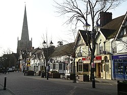
 Solihull High Street | |
| Location | |
| Grid reference: | SP1579 |
| Location: | 52°24’46"N, 1°46’20"W |
| Data | |
| Population: | 126,577 (2021) |
| Post town: | Birmingham, Solihull |
| Postcode: | B36-37, B40, B90-93, B95 |
| Dialling code: | 0121 |
| Local Government | |
| Council: | Solihull |
| Parliamentary constituency: |
Solihull |
Solihull is a pleasant and prosperous town in Warwickshire which lies at the edge of the conurbation stretching out from Birmingham. Solihull lies nine miles south-east of Birmingham city centre across uninterrupted townscape, but the outskirts of Solihull begin to merge into the Warwickshire countryside. Solihull’s population was reckoned at 126,577 in 2021. The local council’s motto, Urbs in Rure (“town in the country”) reflects that dual identity of the country town close into the city.
Solihull may be considered to be a dormitory town for neighbouring Birmingham, although many Solihull folk now work within the town and many commute daily to towns and cities outside the Birmingham conurbation. Solihull remains a distinct town.
History
The town has existed since mediæval times when it was founded as a market town and it later became an important coaching and mail coach stop. Its origin however is unknown and it is not mentioned in the Domesday Book.
Historic buildings of the town
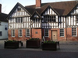
The town is noted for its historic architecture, which includes surviving examples of timber framed Tudor style houses and shops. The historic Solihull School dates from 1560 (although not on its present site). The red sandstone parish church of St Alphege dates from a similar period and is a large and handsome example of classical British church architecture, with a traditional spire 168 feet high, making it visible from a great distance. It is located at the head of High Street and is a Grade-I listed building.[1] It was founded in about 1220 by Hugh de Oddingsell. A chantry chapel was also founded there by Sir William de Oddingsell in 1277 and the upper chapel in St Alphege was built for a chantry. The priest lived and had his sacristy in a crypt chapel underneath, and the fireplace can still be seen there.
20th century

Unlike nearby Birmingham, the Industrial Revolution largely passed Solihull by and until the 20th century Solihull remained a small market town.
The Second World War also nearly passed Solihull by. Neighbouring Coventry and Birmingham were severely damaged by repeated German bombing raids but apart from some attacks on what is now the Land Rover plant, the airport and the local railway lines, Solihull escaped largely intact.
In 1901, the population of the town was just 7,500. However, by the 1960s, the population had grown to over 100,000. This growth was due to a number of factors including a large slum clearance programme in Birmingham, the development of the Rover car plant, the expansion of what was then Elmdon Airport into Birmingham International Airport and, perhaps most significantly, the release of large tracts of land for housing development attracting inward migration of new residents from across Britain.
Until the early 1960s, the main high street remained much as it would have been in the late 19th century with several streets of Victorian terraced houses linking High Street with Warwick Road. The construction of the central shopping area known as Mell Square (named after W Maurice Mell, the town clerk who planned the work) involved the demolition of properties in Mill Lane and Drury Lane, some of which were several hundred years old, together with that of the large Victorian Congregational Church that had stood on the corner of Union Street and Warwick Road.
On the right along High Street from St Alphege's Church porch is one of the town's oldest landmarks, the George (now the Ramada Jarvis Hotel), which dates from the 16th century. On the opposite side of High Street is the Manor House which dates from about 1495.

Work
Solihull offers a variety of shopping facilities. It has an open-air 1960s-style shopping centre called Mell Square which was constructed following the demolition of several terraces of Victorian houses and the original Solihull Congregational Church. In recent years, the town has undergone much development, and High Street has been pedestrianised since 1994. On 2 July 2002, a large new shopping centre, Touchwood, was opened by the Queen.
Solihull is the home of the four-wheel-drive car manufacturer Land Rover and a range of other major companies. The suburb of Meriden was the famous home of the Triumph motorbike factory from 1942-1983. The former home of retail bakers Three Cooks, after it was brought out of administration in 2006, the new company Cooks the Bakery retains its HQ in Solihull.
The National Exhibition Centre, associated with Birmingham, lies within Solihull borough, as do almost all of Birmingham International Airport and the ever-expanding Birmingham Business Park, all providing employment for the people of Solihull and neighbouring towns.
Parks and facilities

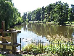
Solihull has a number of parks including Malvern Park, Brueton Park, Tudor Grange Park, Elmdon Park, Hillfield Park, Cole Bank Park, Dorridge Park, Knowle Park and Shirley Park. The nearest parks to the town centre are Malvern and Brueton Parks. They are interlinked and cover about 130 acres. Brueton Park used to be part of the grounds of Malvern Hall, which dates back to about 1690. It is home now to St Martin's Independent School for Girls. Solihull has numerous leisure facilities including a public swimming pool on the edge of Tudor Grange Park. This pool replaced the old Tudor Grange Sports Centre, which was demolished in 2007, to make way for the brand new leisure centre (A combination of the old Norman Green Athletics Centre and Tudor Grange Sports Centre). These centres stood on the existing site since 1960s when they replaced the old outdoor pool. At present there are two sports centres, the more modern Tudor Grange Sports Centre, and the older North Solihull Sports Centre. There is also an outdoor wooden skateboarding and in-line skating facility in Tudor Grange Park. Sailing takes place on Olton Reservoir.
The borough is well served by numerous youth groups, both from the statutory and voluntary sector. There are several Scout groups including Knowle Sea Scout Group which is based in the south of Solihull and is sponsored by the Royal Navy providing a wide programme of activities for young people from all over Solihull aged from 6 to 18. The recently refurbished ice rink on Hobs Moat Road is home to Solihull's ice hockey teams, the Solihull Barons, Solihull Vikings, a junior ice hockey team, the Mohawks ice racing club, as well as ice dance and figure skating clubs. Above the ice rink is a Riley's snooker club.
The River Blythe, a headwater tributary of the River Trent, passes through parts of Solihull including Malvern and Tudor Grange Parks.
Solihull an its associated neighbourhoods have 11 designated Local Nature Reserves: Alcott Wood (Chelmsley Wood), Babbs Mill (Kingshurst), Bills Wood (Shirley), Dorridge Wood, Elmdon Manor, Jobs Close (Knowle), Malvern and Brueton Park (Solihull), Millisons Wood (Meriden), Palmers Rough (Shirley), Smith's Wood and Yorks Wood (Kingshurst).
Suburbs and neighbours
Solihull town has several suburbs including Blossomfield, Solihull Lodge, Haslucks Green, Sharmans Cross, Shirley (considered a suburb of Solihull), Shirley Heath, Hillfield, Monkspath, Widney Manor, Olton and Lode Heath.
Outside Solihull itself lies several satellite towns and villages, some within the conurbation and some separate in the countryside.
Suburban towns and neighbourhoods include:
Separately lie:
- Balsall Common
- Barston
- Bentley Heath
- Catherine-de-Barnes
- Cheswick Green
- Dorridge
- Hampton in Arden
- Hockley Heath
- Knowle
- Meriden
References
- ↑ National Heritage List 1076693: Listing on NHLE
Outside links
| ("Wikimedia Commons" has material about Solihull) |
- Solihull at the Open Directory Project
- Official Solihull Tourism Website
- Solihull Council
- Solihull Observer A local Solihull Newspaper
- Photos of Solihull and surrounding area on geograph
- Solihull Towntalk
- Photographs of Solihull (2010)