San Carlos Water

San Carlos Water is a bay or fjord on the west coast of East Falkland, facing onto the Falkland Sound.
Name
The bay is named after the Spanish ship San Carlos which explored these waters in 1768, a century after Captain Strong named Falkland Sound (which, confusingly the Spaniards name San Carlos after the same vessel).
The settlements of San Carlos and Port San Carlos sit on the shore of the Water, and the San Carlos River flows into it, all taking their name from the same source.
Description
San Carlos Water is a fjord-like inlet at an angle of 45° to the Falkland Sound coastline, thereby offering shelter from the weather in the Sound (which is itself sheltered from the South Atlantic by bluffs in the north and an archipelago in the south). The inlet is 9.3 miles in length and for about half of its length, is about 1.2 miles wide. It is flat-bottomed with a depth of between 65 and 100 feet, the 65-foot isobath lying about 660 feet offshore.[1] The tidal range at Port San Carlos varies between 3.3 and 5.2 feet (for neap and spring tides respectively).[2] The San Carlos settlement lies close to the head of the inlet.
The inlet has eight official anchorage points.[1]
The smaller and shallower Port San Carlos is an inlet to the north of San Carlos Water.[2]
Settlements
History
San Carlos Water became notorious during the Falklands War as "Bomb Alley" during the Battle of San Carlos. British troops routed the Argentine land forces, but the Royal Navy's ships were pounded by Argentine air raids. It was of crucial strategic value in the amphibious assault, and it is from the beachhead here that British forces led the liberation of East Falkland.
Along with Grantham Sound, San Carlos Water is one of the proposed East Falkland termini for the anticipated ferry to West Falkland.
Pictures
-
 Landing site of 2 Para at Blue Beach, San Carlos Water.
 -
 San Carlos Water and landing sites in Falklands War
 -
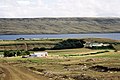 Port San Carlos
 -
 San Carlos
 -
 Gentoo penguins, the current residents of Ajax Bay
 -
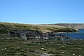 The ruined freezer plant at Ajax Bay
 -
 HMS Antelope returning, 23 May 1982


References
Coordinates: 51°30′29″S 59°04′48″W / 51.508°S 59.080°W