Ravenstonedale
| Ravenstonedale | |
| Westmorland | |
|---|---|
 St Oswalds Church in Ravenstonedale | |
| Location | |
| Grid reference: | NY723040 |
| Location: | 54°25’51"N, 2°25’38"W |
| Data | |
| Population: | 594 (2011) |
| Post town: | Kirkby Stephen |
| Postcode: | CA17 |
| Dialling code: | 01539 |
| Local Government | |
| Council: | Westmorland & Furness |
| Parliamentary constituency: |
Penrith and the Border |
Ravenstonedale is a village in Westmorland, on the watershed between the River Lune and River Eden. Historically also known as "Russendale", the parish is divided into four parts (known as 'angles'): Town, Newbiggin-on-Lune, Bowderdale and Fell End. The origin and etymology of the name are obscure.[1] An alternative spelling may be Rausyngdale [2]
Village
The village is centred on a single main street, though there are many scattered dwellings on the periphery. Slightly to the south east of the village centre is Ravenstonedale Endowed School. There are two inns in the village, and one about two miles outside at Fell End.
St Oswald's church
The parish church, dedicated to St Oswald, dates mainly from the rebuild in the 18th century. The tower dates from 1738, and the rest is of 1744. It has an interesting interior where rows of box pews face a central aisle in the collegiate style. There is a very good example of a three-decker pulpit.
To the north of the church are the excavated remains of a Gilbertine priory, Ravenstonedale Priory, built in the 12th century, which can still be viewed.
Pictures
-
 St Oswald's church
 -
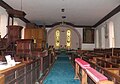 St Oswald's church interior east
 -
 St Oswald's church interior west
 -
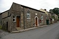 Low Chapel Methodist church
 -
 Village Endowed School
 -
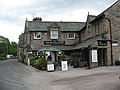 The Black Swan
 -
 The King's Head
 -
 High Chapel, formerly the United Reformed Church, now the Community and Heritage Centre.


Outside links
| ("Wikimedia Commons" has material about Ravenstonedale) |
References
- ↑ Smith, A H (1967). English Place-Name Society: Volume 43, The Place-Names of Westmorland, Part 2. Cambridge University Press. ISBN 0521049369.
- ↑ Plea Rolls of the Court of Common Pleas (National Archives; CP 40/647)