Portland Bill


Portland Bill is a narrow promontory (or bill) of Portland stone, which forms the most southerly part of Isle of Portland, and therefore also of the county of Dorset. One of Portland's most popular destinations, the popular attraction Portland Bill Lighthouse is found in the area, whilst Portland Bill is also noted for its rough coast.
History
The area of Portland Bill was once used for quarrying until the early years of the 20th century. The Portland Bill Lighthouse was built with stone from these quarries and the area was then finally abandoned. Even today, evidence of quarrying tramways can be found. In the storms of January 1990, the weather ripped out an area of cliff top to reveal old rails from the Victorian tramway where it curved round to meet Portland Bill's crane.
Portland had no road reaching to Portland Bill until one was built between the World Wars and visitors originally had to travel over a rough track. A small number of housing is found in the area, largely around the Old Lower Lighthouse, and the housing remains one of the most remote settlements in South Dorset.
The Ministry of Defence Magnetic Range is found at Portland Bill, where tests can be performed away from stray electric and magnetic fields. Close to this range is Portland's "Raised Beach" - created during a warm inter-glacial climate change 200,000 years ago when sea levels were about 15 metres above present levels.[1] A Coastguard station is also located close to Portland Bill.[2]
During the total eclipse of the sun in August 1999, the zone of totality passed less than a mile off Portland Bill, and thousands of people travelled to the area for the experience.[3]
Many beach huts are found in the Portland Bill area, and often sell for prices around £30,000.[4] This is due to the modern planning regulations which were not in force when the huts were originally placed at Portland Bill.[5]
Lighthouses

The Bill is an important way-point for coastal traffic, and so three lighthouses have been built to protect shipping, in particular from its strong tidal race and shallow reef. Both Portland Bill and Chesil Beach are the location of many sunken vessels that failed to reach Weymouth or Portland Roads. The "Portland Race" is caused by the meeting of the tides between the Bill and the Shambles sandbank about 3 miles south-east, and strong currents often break the sea so fiercely that from the shore a continuous disturbance can be seen. The lighthouse's guided vessels heading for Portland and Weymouth through these hazardous waters as well as acting as a waymark for ships navigating the English Channel.[6] The Bill's three lighthouses are the only built on the island, except for the Portland Breakwater Lighthouse, located at Portland Harbour.
The most recent lighthouse is the distinctively white and red striped Portland Bill Lighthouse, which was built in 1906 and is 115 feet high. A popular tourist attraction, tours of the lighthouse are operated by Trinity House, whilst a visitor centre/gift shop is also open during peak season. Due to the construction of the lighthouse, both other lighthouses became disused. The Old Lower Lighthouse became a bird observatory whilst the Old Higher Lighthouse became the home of Marie Stopes, and today remains a holiday let.
Trinity House Obelisk and Pulpit Rock
Nearby to the lighthouse is the Trinity House Obelisk and Pulpit Rock, where both are popular tourist attractions. Pulpit Rock is an artificial stack of rock which was left in the 1870s after a natural arch was cut away by quarrymen at surrounding quarry.[3] A natural solitary rock is also located 500 metres north-east of Portland Bill and has slowly eroded over time, where today it remains a stack.[5]
At the Southern tip of Portland Bill is a 23-foot tall white stone obelisk which was built in 1844 as a warning of a low shelf of rock extending 100 feet south into the sea, which stands near the current lighthouse.[7] The obelisk was saved from threatened demolition in 2002 and once had a viewing platform which is now demolished.[3]
Portland Bill crane
An old wooden crane was once on the cliff edge at Portland Bill, where it was often used to lower fisherman and their boats into the sea. After being destroyed by vandals, the crane was replaced by a steel crane.[3]
Lobster World
During the mid-1980s, plans were submitted to build Lobster World close to the coastguard cottages. The plan was strongly opposed by local people, but despite this, the tourist attraction opened in 1986. Lobster World was a breeding centre for lobsters to be released into the wild. The attraction was not a commercial success and, in 1989, it was converted into a luxury four-bedroom house, where it was put on the market that year for £180,000.[1]
Commercial business
Aside from the Portland Bill Lighthouse gift shop and lighthouse tours, there is a small number of commercial business in the area.
The Lobster Pot Restaurant lies close to the lighthouse, and was established in 1952. Including an indoor restaurant with seating for approximately 90 people, the restaurant also has outdoor seating and a gift shop. In 2011, 2CR fm (now Heart fm) voted the restaurant's scones the best in the South region.[8]
Next to the Lobster Pot was The Cosy Café, which for a long time was a familiar landmark at Portland Bill. In October 2002 a planning application was submitted to demolish the café and by early next year it was gone.
The Pulpit Inn is a family run public house, which also offered three rooms as accommodation. Aside from offered accommodation at both the Old Higher Lighthouse and Old Lower Lighthouse, a bed and breakfast is also found at Portland Bill's Fairview Cottage.
Pictures
-
 Portland Bill
 -
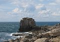 Pulpit Rock at Portland Bill
 -
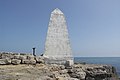 The Trinity House Obelisk
 -
 Portland Bill's Steel Crane
 -
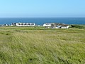 The settlement of Portland Bill
 -
 Beach Huts at Portland Bill
 -
 Pulpit Inn
 -
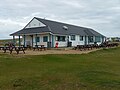 Lobster Pot Restaurant
 -
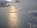 Portland Bill and Chesil Beach from the air


.jpg)


.jpg)

Outside links
- Location map: 50°30’52"N, 2°27’26"W
- Portland Bill Lighthouse - official site
- Portland Bill photographs
- National Coastwatch Institution, Portland Bill
- Portland Bill Lighthouse
- Exploring Portland
References
- ↑ 1.0 1.1 "North of Portland Bill, Portland, Dorset". Geoffkirby.co.uk. http://www.geoffkirby.co.uk/Portland/675685/. Retrieved 2012-11-25.
- ↑ "File:Coastguard station, Portland Bill - geograph.org.uk - 1702400.jpg - Wikimedia Commons". Commons.wikimedia.org. http://commons.wikimedia.org/wiki/File:Coastguard_station,_Portland_Bill_-_geograph.org.uk_-_1702400.jpg. Retrieved 2012-11-25.
- ↑ 3.0 3.1 3.2 3.3 Portland Bill, Portland, Dorset - Geoffkirby.co.uk
- ↑ "beach huts at Portland Bill". Nicktadd.com. 2010-04-04. http://nicktadd.com/beach-huts-at-portland-bill/. Retrieved 2012-11-25.
- ↑ 5.0 5.1 "Lower Lighthouse, Portland, Dorset". Geoffkirby.co.uk. http://www.geoffkirby.co.uk/Portland/680685/. Retrieved 2012-11-25.
- ↑ "Portland Bill Lighthouse". Trinityhouse.co.uk. 1996-03-18. http://www.trinityhouse.co.uk/lighthouses/lighthouse_list/portland_bill.html. Retrieved 2012-11-25.
- ↑ http://www.littledart.co.uk/acatalog/portlandactual.html
- ↑ "The Lobster Pot". Lobsterpotrestaurantportland.co.uk. http://www.lobsterpotrestaurantportland.co.uk/home/about.php. Retrieved 2012-11-25.
| The Isle of Portland, Dorset |
|---|
|
Castletown • Chiswell • Easton • Fortuneswell • The Grove • Portland Bill • Portland Harbour • Southwell • Wakeham • Weston |