Paull
- Not to be confused with Paul
| Paull | |
| Yorkshire East Riding | |
|---|---|
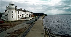
 The Humber Estuary bank and Lighthouse at Paull (2006) | |
| Location | |
| Grid reference: | TA166262 |
| Location: | 53°43’10"N, 0°14’1"W |
| Data | |
| Population: | 723 (2011) |
| Post town: | Hull |
| Postcode: | HU12 |
| Dialling code: | 01482 |
| Local Government | |
| Council: | East Riding of Yorkshire |
| Parliamentary constituency: |
Beverley and Holderness |
Paull is a village in Holderness, in the East Riding of Yorkshire, standing on the north bank of the Humber Estuary, east of the watercourse known as Hedon Haven, and to be found about six miles east of Kingston upon Hull.
Archaically, the village is found recorded variously as Paul, Pall, Pawle, Pawel, Paulle, Paghel, Paghill, Paghil, Pagula.

The western part of the civil parish of Paull centred on the village of Paull on the banks of the Humber Estuary and is bounded by the Hedon Haven watercourse to the west and north, and the Humber Estuary to the south; the north-eastern boundary of the parish is coincident with the Newton Garth, Haylands, Green's, Riggs, and South Ends & Thorney drains; the parish extends some six miles south-east along the bank on a strip almost a mile wide and six miles from Paull bordered to the north by the Sands and Keyingham drains, and the 'Old Channel', with the Ottringham Drain at the eastern boundary. To the north and west are the town of Hedon and the Salt End refinery and chemical works in the parish of Hedon. The other bounding parishes from west to east are Thorngumbald, Keyingham, Ottringham and Sunk Island.
There are historic structures at Paull Battery (now a museum known as Fort Paull) and Paull Holme Tower.
Parish church

The present parish church, St Andrew’s, was built around 1355, replacing a church on the banks of the Humber which was in a ruinous state, and subject to floods.[1]
The church was burnt during the Civil War at the same time the fort at Paull was attacked (on 11 October 1642).[2] It was repaired in 1663, and again around 1700.
In 1841, the church was described consisting of a tower, nave, chancel and north and south transepts, built of stone plus cobbles, with some brick repair work. The tower had a three staged battlemented tower, with pointed windows in the upper (belfry) stage; the nave had two curved and one square headed window on the south side, similar on the north side with three windows and a door; each transept had a large pointed window, Perpendicular in style; the chancel had two windows with a small central door divided by wall buttresses in the south side, and similar buttressing on the north side, but with a window blocked off and a vestry. The buttressing was a mixture of normal, diagonal, and corner buttressing, most of three stages (five at the transepts), with mostly angled buttresses at corners, excluding the west ends of the transepts (single corner), and east end of the chancel (doubled corner).[3] The interior included three sets of octagonal piers in the nave, separating the aisles.[4] The church was restored in 1879, and again around 1890.
Because the church was neither in Paul Fleet, High Paul, or Paul Home a saying arose:
High Paul, and Low Paul, Paul and Paul Holme,
There was never a fair Maid married in Paul town.
— anon, [5]
History

It is a fishing place, and celebrated for shrimps.
— History and Topography of York .. (1856), Sheahan & Whellan.[6]
Paull (Paghel) is listed in the Domesday Book as a places within the Manor of Burstwick.[7] The place is typical of a mediæval settlement in Holderness, occupying higher, and better drained ground in an area prone to flooding.[8]
In the Middle Ages there were three settlements: Paull Fleet (archaic Paul-flete, later Low Paull) near the outfall of the Hedon Haven onto Humber; Up Paull (or Over Paull, later High Paull); and Paull Holme. Paull Fleet and Up/Over Paull merged into a single village Paull in the 16th century.[9]
There was a shipyard at Paull located between High Paul and Paul, took advantage of the sloping beach at that position as a good place for launching ships.[5] The yard built some ships for the Royal Navy: between 1739 and 1774 three warships were built,[10] Thomas Steemson owned the shipyard in the early 19th century;[11] ships of up to 74 guns were built, including HMS Anson (1812).[5] By the 1830s it was no longer active.
Historically Paull was known for shrimp fisheries,[6] in around 1900 the lower part of Hedon Haven (or Paull Creek), and the Humber and Paull roads were access for a numerous fleet of small and medium-sized boats known as 'Paull Shrimpers'; the shrimps were caught in the Humber by beam trawling.[12][13]
Pictures
| ("Wikimedia Commons" has material about Paull) |
Outside links
- Paul Village Hall
- Welcome to Paull: Paull Parish Council
References
- ↑ Pevsner & Neave 1995, p. 645.
- ↑ Poulson 1841, p. 485.
- ↑ Poulson 1841, pp. 485–486.
- ↑ Poulson 1841, p. 486.
- ↑ 5.0 5.1 5.2 Poulson 1841, p. 487.
- ↑ 6.0 6.1 Sheahan & Whellan 1856, p. 842.
- ↑ Paull in the Domesday Book
- ↑ English 1979, p. 184.
- ↑ Smith 2011, pp. 3–4.
- ↑ Browne, Horace B. (1912). The Story of the East Riding of Yorkshire. p. 297. https://archive.org/details/storyofeastridin00browuoft.
- ↑ The Gibsons, a Shipbuilding Family of the 18th and 19th Centuries. pp. 49–50.
- ↑ Watts, A. (1980). "The Paull Shrimper". The Humber: Geography, History, Local Craft. ISBN 9780905490113. http://www.goole-on-the-web.org.uk/main.php?key=671.
- ↑ Smylie, Mike (2012). Traditional Fishing Boats of Britain & Ireland. The Humber.