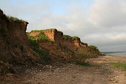
Melton, Yorkshire
| Melton | |
| Yorkshire East Riding | |
|---|---|
 Red Cliff near Melton | |
| Location | |
| Grid reference: | SE971265 |
| Location: | 53°43’34"N, -0°31’47"W |
| Data | |
| Post town: | North Ferriby |
| Postcode: | HU14 |
| Dialling code: | 01482 |
| Local Government | |
| Council: | East Riding of Yorkshire |
| Parliamentary constituency: |
Haltemprice and Howden |
Melton is a small village in East Riding of Yorkshire, about eight miles west of Kingston upon Hull city centre near to the Humber Estuary and about half a mile east of the village of Welton, with which it is nearly contiguous.
Modern geography
The village is bounded to the south by the A63 road, and is half a mile north of the Humber Estuary bank. The village is on the southern edge of the Yorkshire Wolds; to the north-east 'Melton Hill' rises to a height of 302 feet The A63 road passes east–west directly south of Melton, and effectively divides the low-lying clays of the Humber foreshore from the chalk uphills of the Wolds.
History
The land around Melton was enclosed by Act of Parliament in 1771/3.[1] By the beginning of the 19th century the village and environs became the dwelling place of several worthies of Kingston upon Hull; including Benjamin Blaydes (1735–1805),[2] and J. S. Williamson at Melton Hill.[3] In 1823 the population was 107.[4] Melton Grange was built around 1745, Melton Hill to the higher ground north-east of the village was established in the late 1700s, Melton House was constructed around 1830;[5] a Roman burial was discovered near Melton House around 1840, including a gold brooch.[6]

In 1840 the Hull and Selby Railway opened, passing Melton about half a miles south of the village. In 1855 the land around Melton was essential rural, and used for agricultural use, with the exception of the gentrified houses and their gardens, some narrow plantations, and a small brick and tile works south of Melton Common in Melton Ings located on the bank of the Humber Estuary. The brick work's workings continued to expand in the early 1900s and had acquired a tramway system within the clay pits. By the 1920s the tile works had closed, whilst a large scale cement industry had developed; to the north of Melton chalk was extracted at Melton Bottom Quarry, established in 1921, and the Humber Cement Works were established in the same year as Humber Portland Cement Co. Ltd. The works was connected to the main railway, and served by a small railway halt, Melton Halt. The Humber Cement Works also operated an industrial tramway south to the Humber bank, and an aerial cableway connecting the plant to a jetty on the Humber bank at West Clough.
South of the village worker's housing was constructed in the 1920s and 1930s for the Humber Cement Works and for the Capper Pass tin smelter;[5] the Capper Pass works was constructed in the 1930s for Capper Pass and Son to the south of the Hull and Selby railway line and directly east of Humber Cement.
The cement works closed in 1981; a plant supplying Calcium oxide for use in the plastics industry was established on the site in 1990.[7] The Capper Pass smelting works closed and was decommissioned in the early 1990s. It was a major employer in the wider area, but also a polluter due to the nature of the work it performed. In the early 2000s, the site was redeveloped as open air storage and industrial warehousing.
Outside links
| ("Wikimedia Commons" has material about Melton, Yorkshire) |
References
- ↑ Thompson 1870, pp. 3, 51
- ↑ Burke, John; Burke, John Bernard (1847). "Blaydes of Ranby Hall". A genealogical and heraldic dictionary of the landed gentry of Great Britain & Ireland. 1. Henry Colburn. https://books.google.com/books?id=C8fTAAAAMAAJ&pg=PA109.
- ↑ Bigland, John (1812). "North Ferriby". The beauties of England and Wales: or, Delineations, topographical, historical, and descriptive, of each county. 16. pp. 390, also 545. https://books.google.com/books?id=CCRJAAAAMAAJ&pg=PA543.
- ↑ Baines, Edward: 'History, Directory and Gazetteer of the County of York' (1823); page 369
- ↑ 5.0 5.1 Nikolaus Pevsner: The Buildings of England: Yorkshire: York & East Riding, 1972; 1995 Penguin Books ISBN 978-0-300-09593-7page 742
- ↑ Urban, Sylvanus (1840). The Gentleman's magazine (London). 14. William Pickering / John Bowyer Nichols and Son. p. 528. https://books.google.com/books?id=2lkdAQAAMAAJ.
- ↑ "Omya in the United Kingdom - Humber Plant Humber Industrial Estate Gibson Lane Melton North Ferriby". www.omya.com. OMYA. http://www.omya.co.uk/C125736E002FC818/0/9ADC90BCA10173DFC125739400576150?Open®ion=Europe&country=United%20Kingdom&context=global.
- Thompson, Thomas (1870). Researches into the history of Welton and its neighbourhood. Leng & Co.. https://archive.org/details/researchesintoh00thomgoog.
- Gazetteer A–Z of Towns Villages and Hamlets. East Riding of Yorkshire Council. 2006. Melton. http://www.eastriding.gov.uk/hyperlinks/htm_files/A-ZofTowns.pdf. Retrieved 20 February 2012.