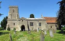
Ludgershall, Buckinghamshire
| Ludgershall | |
| Buckinghamshire | |
|---|---|
 St Mary the Virgin parish church | |
| Location | |
| Grid reference: | SP661174 |
| Location: | 51°51’7"N, 1°2’28"W |
| Data | |
| Population: | 409 (2011) |
| Post town: | Aylesbury |
| Postcode: | HP18 |
| Dialling code: | 01844 |
| Local Government | |
| Council: | Buckinghamshire |
| Parliamentary constituency: |
Buckingham |
| Website: | Ludgershall Village Buckinghamshire |
Ludgershall is a village in Buckinghamshire, near the boundary with Oxfordshire, about 5½ miles south-east of Bicester and 5 miles west of Waddesdon.
Name
The name "Ludgershall" is said to be derived from the Old English for "nook with a trapping spear"[1] but this is disputed.[2] (The name occurs also in Wiltshire.) The Domesday Book of 1086 records the village as Litlegarsele, which may be the Old English Lytel gar sele ("Little spear hall") or lytel gærshæþ ("Little grass heath").
History
Henry II granted land in the parish to the priory of Santingfeld in Picardy, France. It is possible that a hospital was founded on this land, although it is uncertain. In the reign of Henry VI, when all alien church possessions were seized by the Crown, this land was given to King's College, Cambridge.[3][4]
The theologian John Wyclif was vicar of Ludgershall 1368–74.[5]

Outside links
| ("Wikimedia Commons" has material about Ludgershall, Buckinghamshire) |
References
- ↑ Tengstrand, Erik (1940). Genitival Composition in Old English Place-names. Uppsala: Almqvist & Wiksells. p. 219.
- ↑ Ekwall, Eilert (1960). The Concise Oxford Dictionary of English Place-names (4th ed.). Oxford: Oxford University Press. pp. 306–307. ISBN 0-19-869103-3.
- ↑ Page 1905, p. 395.
- ↑ "King’s College Estates Records" (Microsoft Word document). King's College, University of Cambridge. http://www.kings.cam.ac.uk/library/archives/college/hlfproject/estates/manors/ludgershall.doc. Retrieved 30 October 2007.
- ↑ Page 1927, pp. 68–73.
- Hospitals: Ludgershall - A History of the County of Buckingham, Volume 1; Victoria County History
- Ludgershall with Kingswood - A History of the County of Buckingham, Volume 4 (Victoria County History)
- Pevsner, Nikolaus (1973) [1966]. Buckinghamshire. The Buildings of England. Harmondsworth: Penguin Books. pp. 196–197. ISBN 0-14-071019-1.