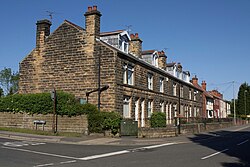
Holmgate
Jump to navigation
Jump to search
| Holmgate | |
| Derbyshire | |
|---|---|
 Henmill Cottages, Holmgate | |
| Location | |
| Grid reference: | SK372633 |
| Location: | 53°10’9"N, 1°26’10"W |
| Data | |
| Post town: | Chesterfield |
| Postcode: | S45 |
| Local Government | |
| Council: | North East Derbyshire |
| Parliamentary constituency: |
North East Derbyshire |
Holmgate is an estate situated in the town of Clay Cross, in the north-east of Derbyshire.
The village sits between Clay Cross and Ashover. It is within easy reach of the 'crooked spire' town of Chesterfield, also Bakewell and Matlock, so that it provides a base for exploring the Peak District, Nottinghamshire ('Robin Hood Country') and the West Riding of Yorkshire. Several stately homes and National Trust properties are less than half an hour's drive away.
Churches
Holmgate Evangelical Church started in 1974 in a Community Centre, the church grew and moved into its own building in 1981.[1]