Brigg
| Brigg | |
| Lincolnshire | |
|---|---|
 Wrawby Street, Brigg | |
| Location | |
| Grid reference: | TA003073 |
| Location: | 53°33’10"N, 0°29’6"W |
| Data | |
| Population: | 5,076 (2001) |
| Post town: | Brigg |
| Postcode: | DN20 |
| Dialling code: | 01652 |
| Local Government | |
| Council: | North Lincolnshire |
| Parliamentary constituency: |
Brigg and Goole |
Brigg is a small market town in Lincolnshire, within the Yarborough Wapentake in the North Riding of Lindsey. The town had a population of 5,076 in 2,213 households recorded at the 2001 census.
Brigg stands at the junction of the River Ancholme and east-west transport routes across northern Lincolnshire. As a formerly important local centre, the town's full name of Glanford Brigg[1] is reflected in the surrounding area. The town's urban area includes the neighbouring hamlet of Scawby Brook.
Geography

Brigg in the north of the county and the nearest big towns are Lincoln 22 miles to the south, Scunthorpe 7 miles to the west, Grimsby 17 miles to the east, and Hull 15 miles to the north, across the Humber in Yorkshire. The local area is broadly the south bank of the Humber estuary.
The town itself sits on a gravel spur of the Lincolnshire Wolds that juts out into the valley of the Ancholme, a tributary of the Humber, which historically provided a narrow crossing point of the river and its flood plain.[2] The Wolds proper rise to the east, reaching a maximum of roughly 350 feet about 3 miles from the town, although with a lower pass at the Kirmington Gap. To the west the land gently slopes up to roughly 230 feet on the Lincolnshire Edge about 3 miles away.
Between these low ranges of hills the Ancholme river runs south to north through its flat, low–lying flood plain, with a north–south height difference of only a few metres. The town sits on alluvial soils of the Ancholme, and the area surrounding the town was previously a semi–flooded marsh known as carrs. A series of drainage improvements from the 1630s to the 1820s transformed the whole of the valley into arable land. The largest of the drainage channels is also a canal known as the New River Ancholme. The original course of the river has been obliterated in places by the drainage works, but its discontinuous surviving length is known as the Old River Ancholme.
The town itself lies mostly on the east bank of the old river, with a small amount to the west. A portion of the west bank is cut off from the rest by the new river, forming an island–like piece of land known as Island Carr. Due to nearness of the river, the town regularly suffers minor flooding, and concerns over flood plain development are a major issue in local planning.[3] The only other watercourse of reasonable size is Candley Beck, which runs through the very southern parts of the town. There are also about half a dozen clayponds along the riverside in Brigg where clay was formerly extracted for brick–making.
Parish church
The church of Saint John the Evangelist, built in 1843, stands on Bigby Street. Its style is of the Gothic Revival architecture popular at the time, but Pevsner notes the curious construction where the stone has first been carved into the shape of bricks before being laid in courses.[4]
Townscape

The old town is centred on the marketplace and the adjoining streets of Bridge Street, Wrawby Street, and Bigby Street. The marketplace and Wrawby Street, where much of the town's retail is located, were pedestrianized in the early 1990s. A significant number of buildings in the town centre date to the late 1700s or early 1800s and are listed, and the old town as a whole is designated a Conservation Area.
The marketplace is dominated by the Buttercross and the Angel, a former coaching inn with an early mock Tudor façade, which is now home to Brigg Town Council. Another former coaching inn, the Exchange, stands in Bigby Street, opposite the former manor house of the Elwes family.
Much of the town's poorer housing formerly lay in a series of narrow yards that ran northward from the marketplace and Wrawby Street.[5] The yards were considered unsanitary slums by the late 1800s, but the housing was not finally vacated and demolished until the 1950s.[5] However, the yards themselves remain in use, with the larger ones repurposed for retail and services, and the smaller for public alleys.
The A18 bisects the town, running just north of the town centre. To the north and east of this road, housing development throughout the 1900s expanded the town significantly in size. To the west beyond the New River Ancholme, the town's urban area continues into the neighbouring hamlet of Scawby Brook. The settlement is substantially bounded by the M180 motorway to the north and the Sheffield to Lincoln railway line to the south.
History
The area of present-day Brigg has been used for thousands of years as both a crossing point of the Ancholme and for access to the river itself. Prehistoric boats of sewn–built[6] and dugout[7] construction have been found in the town, both dating to around 900 BCE. A causeway or jetty also stood on the riverside during the late Bronze Age, although its exact use is uncertain.[8]
During the Anglo-Saxon period the area became known as Glanford. The first element of the name is unclear; it is possibly derived from the Old English gleam meaning joy or revelry, and thus the full word is interpreted as "ford where sports are held".[9] Another suggestion is that the first element refers to a 'glamping' track—a walkway formed by placing interlocking planks or logs over boggy ground—and thus describes a ford crossed in this manner.[10] A third possibility is that it means "smooth ford"[11] although its etymology is not specified.
Glanford Brigg was founded as a new town at the crossing place of the Ancholme before 1183, its first mention being a Pipe roll entry for that year.[12] The town's formal charter for a weekly market and yearly fair date from a royal grant to Hugh Nevil in 1205, in which the founder's name is given as his father–in–law Stephen de Camera.[13] The fair began on 25 July—the feast of Saint James—and continued for three days afterward. The grant of a market and fair were subsequently reconfirmed to Hugh's son Ernisius in 1235. The second part of the town's full name dates to this time, coming from the new bridge built to replace the existing ford. Its non–standard form of Brigg is due to influence from Old Norse bryggja, which although usually describes a jetty or quay here refers to a bridge.[9]
Brigg originally sat at the meeting point of four parishes—Broughton, Kettleby, Scawby, and Wrawby—although it lay mainly in the last, and was officially regarded as part of that village. In the 1190s, the lord of the manor of Broughton, Adam Paynel, founded a hospital for the poor within the town.[14] Several small chapels also existed during mediæval times, with another hospital and chapel founded by William Tyrwhitt in 1441.[14] However, the dissolution of the monasteries in 1536–41 also affected hospitals and chapels, leaving the town without ecclesiastical coverage except the parish church in nearby Wrawby.[14]

Due to its strategic position, Brigg was fortified by Royalist forces during the Civil War. After the Battle of Winceby in 1643, Parliamentarian forces attacked and seized the garrison on their way to help relieve the siege of Hull.[15] Sir John Nelthorpe, a local landowner who had been a member of Parliament during the Protectorate, bequeathed some of his estate in 1669 for the foundation and maintenance of a free school in the town. Four other local gentlemen established a chapel of ease in Bigby Street in 1699, restoring church presence in the town after 150 years of absence.[14]
The town was substantially improved and rebuilt in the late 1700s and early 1800s, partly through the demands of the Elwes family, the largest landowner in the town.[16] The old town hall, now known as the Buttercross, was built in 1817.[16] Later, in 1842–43, the existing chapel of ease was replaced by a full–sized church dedicated to St John the Evangelist,[17] and a cemetery was established on Wrawby Road in 1857, following significant controversy over the burial of non–conformists. Brigg's ecclesiastical parish was established in 1872,[16] finally separating the town from Wrawby, but also incorporating neighbouring parts of Scawby, Broughton, and Bigby parishes.
A workhouse was built at the east end of the town in 1835, and was the responsibility of the Glanford Brigg Poor Law Union.[1][18] Its architect was William Adams Nicholson who also designed the similar building in Lincoln, and replaced an earlier alms house dating back to 1701. The workhouse at Brigg is one of the best known and best documented of its type, probably because of the national interest that arose after Percy Grainger collected traditional songs from the inmates. An infirmary was later built attached to the workhouse, and this portion remained open as a hospital until 1991.[7]
Economy

The economy of Brigg is substantially retail and service based, and according with its traditional position of a market town, it acts as a service centre for the surrounding rural area. The main shopping street is Wrawby Street, although retail is present throughout much of the old town.
Many of the businesses are independent, retaining the character of the traditional high street, although some chain retailers have large stores in the town.
A general market is held on Thursdays and Saturdays, and a farmers' market is also held on the fourth Saturday of each month, selling local produce from pork and organic vegetables to ostrich meat, and locally produced condiments.[19]
Light industry is present on the Island Carr and Atherton Way industrial estates. A 260 MW gas–fired power station, owned by Centrica, sits to the south–west of the town.[20] A second, 40 MW straw–fired, power station has been approved for construction alongside.[21] A significant number of residents commute to work in nearby Scunthorpe and Grimsby, although the town is not characterized as a commuter town.
Past industries were more strongly connected to the rural economy, such as a beet sugar factory in Scawby Brook, a livestock market, and Spring's jam factory; the latter being a nationally known brand. A corn exchange was built in the town in the 1800s, and the local corn prices were quoted nationally. The town was home to the Falcon Cycles factory for much of its independent existence, the company having moved to Brigg from nearby Barton-upon-Humber in the early 1900s.
Culture and community
Culture in Brigg is mostly small–scale and self–organized, although there are a few larger events. Currently, there are three yearly general fairs: the Summer Fest in June, the Horse Fair in August and a Christmas Fair at the end of November. More specialized events include the North Lincolnshire Music and Drama Festival in March, a beer festival in May, and the Briggstock Acoustic Music Festival in early September. Brigg Live Arts also hold a two–yearly cultural festival and art exhibition in the town.

Brigg has numerous traditional pubs: the Black Bull, Britannia and the White Horse Inn on Wrawby Street, the Woolpack Inn and Lord Nelson in the Market Place, the Exchange Hotel and the Dying Gladiator on Bigby Street, and the Nelthorpe Arms, the White Hart and the Yarborough Hunt on Bridge Street.
Horse Fair
The town hosts a yearly horse fair on the first Saturday of August. Large numbers of Gypsies and Irish Travellers come from across the land to attend the event. The fair is partly an opportunity to buy and sell horses, but also presents a significant opportunity for community socializing. For several decades local volunteers organized the official fair and promoted it as a tourist event, but in recent years it has been left unorganized and unofficial.
The fair has been claimed to be the largest horse fair in Britain after Appleby Horse Fair. It is also the surviving continuation of the mediæval fair which was in existence at least as early as 1205, meaning it is now over 800 years old. The difference in date—from 25 July to early August—is a result of the eleven days 'skipped' upon the adoption of the Gregorian calendar in 1752. The fair is also the subject of a well–known folk song Brigg Fair, see below.
Folk Song
Brigg is the source of several early recordings of folk songs which subsequently inspired other composers.
At competitions arranged by Gervase Elwes in 1905-06, several folk singers from the surrounding area—including Joseph Taylor and George Gouldthorpe—sang for the composer Percy Grainger songs such as Brigg Fair and Lisbon. He also collected Horkstow Grange at nearby Redbourne.[22] These songs inspired Grainger's work Lincolnshire Posy and subsequently Frederick Delius's own Brigg Fair.
Sport and leisure
- Football: Brigg Town Football Club, known locally as the Zebras for their black and white striped home kit. Claimed to have been established in 1863, the team is allegedly the oldest association football club in Lincolnshire and among the oldest surviving clubs in the world.
- Rowing: The Ancholme Rowing Club, founded in 1868, based in Manley Gardens. It holds an Annual Head Race every October, attracting crews from across the Midlands and Yorkshire.
- Athletics: Lincsquad hold two triathlons and a quadrathlon in and around the town every year.[23]
The Recreation Ground on Wrawby Road provides an area for field sports. Ancholme Leisure Centre is on Scawby Road (A18) in Scawby Brook, to the west of the town. Its facilities include swimming pools, a sports hall, and a skatepark.
Transport links
The main transport to and from Brigg is by road. The A18 passes east–west through the town, connecting into the national road network, with the A1084 (Bigby Road) heading south–east to Caistor. The M180 bypasses the town carrying longer distance traffic, including the A15 between Lincoln and Hull. A few bus services operate in and from the town.
Brigg railway station[24] is on the Grimsby branch of the Sheffield to Lincoln Line. The passenger service is limited, with only six trains a week, all on Saturdays. However, the line is still used regularly for freight transport. There is a level crossing over the A1084.
Humberside International Airport, near the village of Kirmington, is about 5 miles away.
The Ancholme river, although once extensively used for transport,[16] is now mostly used for leisure. There is no significant transport of either passengers or freight on the river.
Pictures
-
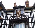 The Angel
 -
 The Dying Gladiator Inn
 -
 Marketplace


Outside links
- Brigg Town Council
- Brigg Town History
- Brigg Town Football Club
- This is Brigg - a website of the Scunthorpe Telegraph
- Brigg Record - community news website
- Ancholme Rowing Club
- Description of the workhouse history
- Brigg Amateur Social Historians (BASH)
- Brigg Blog
- Brigg People
References
- ↑ 1.0 1.1 National Monuments Record: No. 922373 – Forms of name
- ↑ Leahy, Kevin (2010). The Anglo–Saxon Kingdom of Lindsey (2nd ed.). History Press.
- ↑ This is Scunthorpe: £60,000 scheme to cut flood risk in Brigg gets under way
- ↑ Nikolaus Pevsner: The Buildings of England: Lincolnshire, 1964; 1989 Penguin Books ISBN 978-0-300-09620-0
- ↑ 5.0 5.1 Lyons, Nick (1983). The Courts and Yards of Brigg. Scunthorpe Museum Society.
- ↑ McGrail, Sean (1981). The Brigg 'Raft' and her Prehistoric environment. British Archaeological Reports.
- ↑ 7.0 7.1 Dodd, Edward (1991). Brigg.
- ↑ Wylie, William: Prehistoric Road at Brigg, Lincolnshire (Proceedings of the Society of Antiquitaries, 1884 volume 10; 2nd series) pages 110–115
- ↑ 9.0 9.1 Cameron, Kenneth (1991). The Place-Names of Lincolnshire. Part Two.
- ↑ Cooper, C H (1994). Historical origins of Lincolnshire villages: and Lincoln street names. Lincolnshire Publishing.
- ↑ Glanford Borough Council Leisure Services Department (1988). Like a dream remembered: a short history of the Borough of Glanford. Glanford Borough Council.
- ↑ Beresford, Maurice: New Towns of the Middle Ages: Town Plantation in England, Wales and Gascony (Alan Sutton, 1988) ISBN 0-86299-430-6, page 670 (2nd ed page 465)
- ↑ "Brigg Market Town: History". http://www.briggmarkettown.co.uk/history.php.
- ↑ 14.0 14.1 14.2 14.3 Dodd, Edward (1990). The History of Catholicism in Brigg and District.
- ↑ Holmes, Clive (1980). Seventeenth-Century Lincolnshire. History of Lincolnshire Committee.
- ↑ 16.0 16.1 16.2 16.3 Henthorn, Frank (1987). History of 19th Century Brigg. Spiegl.
- ↑ Cox, J. Charles (1916) Lincolnshire p. 81; Methuen & Co. Ltd
- ↑ National Monuments Record: No. 1451999 – The Workhouse
- ↑ Visit Lincolnshire: Brigg Farmer's Market
- ↑ "Centrica: Gas fired power stations". http://www.centrica.com/index.asp?pageid=924.
- ↑ "Eco2: Brigg Renewable Energy Plant". http://www.eco2uk.com/en/our_projects/project_detail.asp?project_id=11.
- ↑ Thomas Lewis: "A Source Guide to the Music of Percy Grainger
- ↑ LINCSQUAD–Lincolnshire Quadrathlon Club
- ↑ National Monuments Record: No. 498215 – Brigg Railway Station