Ettrick Bay

Ettrick Bay is a wide, tidal, sandy coastal bay a mile across on the west coast of the Isle of Bute in Buteshire.
The bay was used for practice training for the D-Day landings.[1]
Geography
The bay faces the Kyles of Bute, the sea channel that separates the northern end of the islands from the Cowal peninsula of Argyllshire, and offers views of the Buteshire's largest island, Arran.
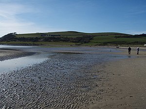
The bay is bounded by a coarse sandy beach which is popular with tourists and local people. During low tide, the water's edge can be up to 550 yards from the high tide mark. A number of rivers flow into the bay, including the Glenmore Burn, Ettrick Burn, Drumachloy Burn and St Colmac Burn.
At the north end of the bay, which mainly consists of rocky outcrops, stands the Kildavanan Point, with the feature known as Macallister's Gun, located close to the point. At the south end of the bay is the rocky outcrop called Island McNeil, which forms the outer boundary of the bay.
The island's highest hill, Windy Hill (912 feet), stands directly to the north of the bay. Other, smaller hills surrounding the bay include:
- Eanan Hill to the north east (545 feet)
- Glenabea Hill, behind Eanan Hill (659 feet)
- Kilbride Hill, which bounds Windy Hill at the east side (840 feet)
- Muirton Hill, which is to the south of Windy Hill (840 feet)
Three miles south of Ettrick Bay lies a sheltered bay known as St Ninian's Bay, which is named after the 8th-century missionary saint, St Ninian.
Another of Buteshire's islands, Inchmarnock, can be seen from Ettrick Bay away to the south at the northern end of the Sound of Bute in the Firth of Clyde.
About the bay
A Bronze Age stone circle is situated at St Colmac Farm, which is located south of the B875 road to Ettrick Bay from Port Bannatyne, about half a mile north-east of the bay shore. A ruined 19th-century church, St Colmac's Church, stands about a hundred yards from the stone circle.[1] The church's manse is contemporary with the fallen church.
At the bridge over Glenmore Burn lie concrete frames built for the Army for exercises on Inchmarnock. These frames represented practice landing craft for the D-Day landings.[1]
Picture
| ("Wikimedia Commons" has material about Ettrick Bay) |

Stone Circle near St Colmac Farm
Ettrick Bay
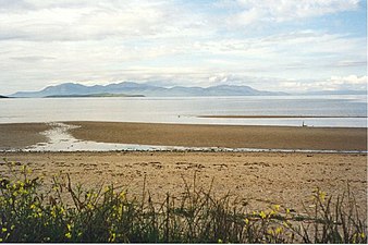
Ettrick Bay looking towards Arran

Looking towards Kildavanan Point

A stormy Ettrick Bay with Arran beyond

Ettrick Bay beach

The beach

The ruined Drumachloy Bridge

Ettrick Bay looking south


Location
- Location map: 55°50’40"N, 5°8’33"W
References
- ↑ 1.0 1.1 1.2 Haswell-Smith, Hamish (2004). The Scottish Islands. Edinburgh: Canongate. ISBN 1841954543.