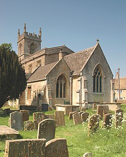
Chadlington
| Chadlington | |
| Oxfordshire | |
|---|---|
 St. Nicholas, Chaddington | |
| Location | |
| Grid reference: | SP329221 |
| Location: | 51°53’50"N, 1°31’20"W |
| Data | |
| Population: | 827 (2011) |
| Post town: | Chipping Norton |
| Postcode: | OX7 |
| Dialling code: | 01608 |
| Local Government | |
| Council: | West Oxfordshire |
| Parliamentary constituency: |
Witney |
Chadlington is a village in the valley of the River Evenlode in the west of Oxfordshire about three miles south of Chipping Norton. The village has four neighbourhoods: Brookend, Eastend, Greenend and Westend.
Churches
The Church of England parish church, St Nicholas was originally built in the Norman age,[1] and the blocked head of a Norman window above the north arcade show that the building had a clerestory in Norman times.[1] The church's orientation, which is almost south-west/north-east, is somewhat idiosyncratic, and might suggest that it was inserted into the framework of a pre-existing settlement plan. In the 13th century, north and south aisles were built, in the Early Gothic style. The bell tower was built early in the 14th century in the Decorated Gothic style.[2] A chapel was added at the east end of the north aisle. In 1870, the Gothic Revival architect Charles Buckeridge completely rebuilt the chancel.[2] St. Nicholas' church is a Grade II* listed building.[3]
Chadlington Baptist chapel was built in 1840.[2] It is now a private house.
Chadlington has a Methodist church. It is a member of Chipping Norton and Stow on the Wold Methodist Circuit.
History
Archaeology
A late Neolithic or early Bronze Age bowl barrow is found about a mile and a half west of the village, and is a scheduled monument.[4] A hillfort, known as Knollbury, is a mile north-west of the village. It too is a scheduled monument.[5]
Manors
Chadlington appears to have been at the head of its own hundred both before and after the Norman Conquest, but later on, together with two other hundreds, it became amalgamated into the single Hundred of Shipton. Two separate estates at Chadlington existed by the time of Domesday Book in 1086, each of two and a half hides, no doubt once a typical five-hide holding split in two before the Conquest.[6]
The present Chadlington Manor House is said to be of 17th century date,[2] remodelled in about 1800.[7] However, it is likely that its site is far older. It is a Grade II* listed building.[7] Lower Court farmhouse was built in about 1700 as the manor house for Westend.[8]
Modenity
Chadlington used to have three public houses, the Malt Shovel (closed down),[9] the Tite Inn, and the Sandys Arms. The Tite Inn was closed between 2009 and 2012; it reopened in 2012 with new owners.[10] and the Sandys Arms on Bull Hill closed some years earlier.[11]
Sport
- Football: Chadlington Football Club
- Cricket: Chadlington Cricket Club
- Both clubs are based at Chadlington Sports and Social Club.[12]
An annual fun run is held along Coldron Brook: The Great Brook Run. Proceeds of the race, which starts and ends at The Tite Inn, go to the parish primary school.
In popular culture
Chadlington is the location for filming of the television documentary series Clarkson's Farm about Jeremy Clarkson and his farm on the edge of the village.
Outside links
| ("Wikimedia Commons" has material about Chadlington) |
- "Site name: Chadlington". Oxfordshire's Historic Archives. Ashmolean Museum. June 2006. http://historicoxfordshire.ashmolean.org/SitePages/chadlington.html.
- "Chadlington Anglo-Saxon Cemetery". Anglo-Saxon Oxfordshire. Ashmolean Museum. 22 December 2005. http://www.ashmolean.org/ash/amps/leeds/AS_Oxfordshire/chadlington/chadlington_index.html.
References
- ↑ 1.0 1.1 Sherwood & Pevsner 1974, p. 524.
- ↑ 2.0 2.1 2.2 2.3 Sherwood & Pevsner 1974, p. 525.
- ↑ National Heritage List 1368037: Church of St Nicholas, Eastend (Grade II* listing)
- ↑ National Heritage List 1014562: Bowl barrow north of Barter's Hill Farm (Scheduled ancient monument entry)
- ↑ National Heritage List 1015322: Knollbury camp hillfort (Scheduled ancient monument entry)
- ↑ Caldwell, Clare (editor, with John Morris) (1978). Domesday Book: Oxfordshire. London and Chichester: Phillimore. ISBN 0850331692.
- ↑ 7.0 7.1 National Heritage List 1052835: Manor House and Attached Walls and Outbuildings
- ↑ National Heritage List 1368038: Lower Court Farmhouse (Grade II listing)
- ↑ Simon Hall. "The Lost Pub Project, Malt Shovel". http://www.closedpubs.co.uk/oxfordshire/chadlington_maltshovel.html.
- ↑ "About us (and the Tite)". http://www.thetiteinn.co.uk/about/.
- ↑ National Heritage List 1052832: Sandys House (Grade II listing)
- ↑ Chadlington Sports Club
- Corbett, E. (1962). A History of Spelsbury. Banbury: Cheney and Sons. p. 20.
- Gilmour, Lauren (1992). "The Chadlington Sword — and the end of the siege of Oxford?". Oxoniensia (Oxfordshire Architectural and Historical Society) LVII: 359–363. http://oxoniensia.org/volumes/1992/notes.pdf#page=21.
- Edward Thurlow Leeds (1940). "Two Saxon Cemeteries in North Oxfordshire". Oxoniensia (Oxford Architectural and Historical Society) V: 21–32. http://oxoniensia.org/volumes/1940/leeds2.pdf.
- Mudd, Andrew (1987). "Fieldwalking at Spelsburydown and in the Chadlington Area". Oxoniensia (Oxfordshire Architectural and Historical Society) LII: 11–22. http://oxoniensia.org/volumes/1987/mudd.pdf.
- A History of the County of Oxford - Volume 1 pp 357-360: Anglo-Saxon Remains (Victoria County History)
- Nikolaus Pevsner: The Buildings of England: Oxfordshire, 1974 Penguin Books ISBN 978-0-300-09639-2page 524-525