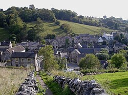
Bonsall
| Bonsall | |
| Derbyshire | |
|---|---|
 Bonsall village | |
| Location | |
| Grid reference: | SK279582 |
| Location: | 53°7’16"N, 1°35’2"W |
| Data | |
| Population: | 775 (2001) |
| Post town: | Matlock |
| Postcode: | DE4 |
| Dialling code: | 01629 |
| Local Government | |
| Council: | Derbyshire Dales |
| Parliamentary constituency: |
Derbyshire Dales |
| Website: | Bonsall Village |
Bonsall is a village in the midst of Derbyshire, at the edge of the Peak District. It is to be found about five miles from Matlock and about 18 miles from Derby.
The population of the civil parish, including Brightgate and Horse Dale, was 803 at the 2011 Census.
Bonsall has a long history of lead mining, along with its neighbouring town of Wirksworth, probably going back to Roman times. It is recorded in the Domesday Book.
The village is on the Limestone Way long distance walking route, at the head of its branch to Matlock, and on the Peak District Boundary Walk.[1]
Parish church
The Parish Church is St James the Apostle. Parts of it date from the 13th century, including the north side of the chancel and the arcade of the south aisle. The arcade of the north aisle is later and so is the Perpendicular Gothic tower. The outer walls of the church were rebuilt in 1861–62 under the direction of the Gothic Revival architect Ewan Christian.[2]
About the village
There is a market cross in the village centre that may date from the Middle Ages. The ball on top was added in 1671.[2] Bonsall applied for a market charter some three hundred years ago, but was rejected.[3]
The Manor House was built in about 1670 and the Kings Head public house was established in 1677.[2]
The approach to the village is via a steep hill leading up from Via Gellia (now the A5012 road) and nearby Cromford. The road is called the 'Clatterway'.
Textiles and lead mines
Bonsall inhabitants have been involved in the textile industry, before and after Richard Arkwright. Around 1850 Bonsall was a farming village surrounded by lead mines and busy outworker frame-knitting workshops. A few 18th- and 19th-century frame-knitting workshop buildings survive.[2] Many people also worked in the cotton spinning mills at Cromford and the Via Gellia. In early modern times Bonsall was on an important salters' route, and was a staging post on the road between Derby and Manchester.
Economy and amenities

Bonsall remains a working village that is involved in agriculture, heavy goods transport and a range of forms of information technology. However, most people in the village travel to cities such as Derby, Nottingham and Sheffield for work. The village supports two public houses, the Barley Mow[4] and the Kings Head.
The parish has a Church of England primary school.[5]
Bonsall Camp
Bonsall Camp in Uppertown is a Christian youth camp, owned by the Christian Youth Foundation, a charity that runs several residential children's and youth weeks in the summer holidays. Camps have been run here for more than 60 years. The Christian author Selwyn Hughes recalls in his biography the time he was sent home from the camp for bad behaviour.
Events
Attractions include the Annual "World Championship Hen Race" held annually in August at the Barley Mow public house. This event was run for the first time in 1992.
Outside links
| ("Wikimedia Commons" has material about Bonsall) |
References
{{reflist}
- ↑ McCloy, Andrew (2017). Peak District Boundary Walk: 190 Miles Around the Edge of the National Park. Friends of the Peak District. ISBN 978-1909461536.
- ↑ 2.0 2.1 2.2 2.3 Nikolaus Pevsner: The Buildings of England: Derbyshire, 1953; 1978 Penguin Books ISBN 978-0-300-09591-3pages 101–102
- ↑ Sharpe, Neville T (2002). Crosses of the Peak District. Landmark Collectors Library. Ashbourne: Landmark Publishing Ltd.. p. not cited. ISBN 1-84306-044-2.
- ↑ Barley Mow, Bonsall
- ↑ "Bonsall CE Primary School". http://www.bonsall.derbyshire.sch.uk/.