Bingfield
| Bingfield | |
| Northumberland | |
|---|---|
 Bingfield | |
| Location | |
| Grid reference: | NY975725 |
| Location: | 55°2’49"N, 2°2’28"W |
| Data | |
| Post town: | Newcastle Upon Tyne Hexham |
| Postcode: | NE19 and NE46 |
| Dialling code: | 01434 |
| Local Government | |
| Council: | Northumberland |
| Parliamentary constituency: |
Hexham |
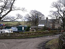
Bingfield is a village in Northumberland. It is situated to the north of Corbridge, off the A68 road, though it encompasses some houses along that road, which is the course of ancient Dere Street.
History of Bingfield
The remains of an ancient mediæval village in the field in front of the church were uncovered during an oil excavation.
Bingfield likely developed from a farming community in the early 19th century, and most of the buildings date to that era. There were probably four farms: the present farm at the bottom of the road (now owned by the Whites and Sistersons); the Scott's farm, located about half a mile from Bingfield Combe Cottage, which consists of a massive farmhouse and several barn houses, now converted into homes. There is a smaller farm fifty yards opposite from the original farmhouse at the bottom of the hill, which was owned by the Scotts and Bingfield east quarter. There was also a school in Bingfield, and a church which dates to the late 18th/early 19th century, serving Bingfield and neighbouring Hallington.
Bingfield remained largely unchanged from the mid 19th century until after the Second World War, when mechanisation changed the face of farming: the farms of the parish consolidated and new houses were built, particularly since the 1970s.
Outside links
| ("Wikimedia Commons" has material about Bingfield) |