Astley, Lancashire
| Astley | |
| Lancashire | |
|---|---|
 Bridgewater Canal and Astley Green Pithead | |
| Location | |
| Grid reference: | SD699006 |
| Location: | 53°30’3"N, 2°26’43"W |
| Data | |
| Population: | 11,654 (est.) |
| Post town: | Manchester |
| Postcode: | M29 |
| Dialling code: | 01942 |
| Local Government | |
| Council: | Wigan |
| Parliamentary constituency: |
Leigh |
Astley is a village which has become swallowed in the conurbations of southern Lancashire and which finds itself as frequently termed a mere suburb as a village of itself. It s found to the north-west of the City of Manchester.
The Bridgewater Canal and the A580 East Lancashire Road run through here, and Astley forms a continuous urban area with neighbouring Tyldesley. It is equidistant between from Wigan and Manchester city centre, both eight miles away.
The name Astley is derived from Old English, probably from East leah meaning "east meadow / clearing",[1] though it may indicate its position east of Leigh.[1] From the Middle Ages, Astley has constituted a township within the ancient parish of Leigh and the West Derby Hundred. Astley first appears in written form as Asteleghe in 1210, when its lord of the manor granted land to the religious order of Premonstratensian canons at Cockersand Abbey.[2] Other archaic spellings include Asteleye (1292) and Astlegh (14th and 15th centuries).[2]
Mediæval and Early Modern Astley is distinguished by the dignitaries who occupied Damhouse, the local manor house around which a settlement expanded. The newly extended Bridgewater Canal reached Astley in 1795, and the Liverpool and Manchester Railway in 1830. The Industrial Revolution introduced mechanised coal mining and the factory system to the region in and around Astley, triggering its expansion. The village's only cotton mill was built in 1833.
Mining subsidence coupled with structural and political changes to the mining industry began the decline in Astley's industrial activities during the mid-20th century; its cotton mill closed in 1955, and the last coal was brought to the surface in 1970. However, Astley has grown as part of a commuter belt, supported by its proximity to Manchester city centre and inter-city transport links. Astley Green Colliery Museum houses collections of Astley's industrial heritage.
History
Early history
The earliest evidence of human activity in the area is the remains of a Roman road which served as the route between Roman camps at Coccium (Wigan) and Mamucium (Manchester). The road ran to the north of Astley, past Keeper Delph and through Tyldesley.[3] Evidence for the presence of Anglo-Saxons in the sparsely populated, heavily wooded and isolated region is provided by place names incorporating the Old English suffix leah, such as in Leigh, Tyldesley, Shakerley and Astley.[4]
Manor
Astley emerged during the Early Middle Ages as a township in the parish of Leigh. It was mentioned in documents in 1210, when Hugh of Tyldesley, Lord of the Manors of Tyldesley and Astley, granted land to Cockersand Abbey. In 1212, he was recorded as tenant of Astley Hall, the manor house for both Astley and Tyldesley, located just inside the Tyldesley township. After his death, his son Henry inherited the manors. He was succeeded by his son, another Henry, who, when he died in 1301, divided the lands between three of his six sons. It is from this division that the manors of Astley and Tyldesley were separated. Tyldesleys lived at the Astley manor until April 1353 when Richard Radcliff bought it for 100 marks.[5] The Radcliffs remained there until 1561 when William Radcliff died childless and the land passed to his half-sister Anne, who married Gilbert Gerard.[6]

In 1606 Adam Mort bought the manor house and land in Astley.[7] He was a wealthy man who built the first Astley Chapel as a chapel of ease for the parish church in Leigh. The chapel was consecrated in 1631, the year that he died. He built a grammar school that stood for over 200 years until 1833, when it was demolished and rebuilt. Adam Mort's grandson, also Adam, rebuilt Damhouse in 1650 and his initials are carved in the plaque over the front door.[8] The stone and timber structure was named from the stream which was dammed to supply water to a waterwheel powering a corn mill near the house. It is possible the hall was once surrounded by a moat.[9][10]
Adam Mort's descendants continued to support the chapel and school and remained at Damhouse until 1734 when it was bought by Thomas Sutton.[11] After Sutton's death in 1752 the house was inherited by Thomas Froggatt of Bakewell who contributed to rebuilding the chapel in 1760. Froggatt's descendants owned Damhouse until 1800 when it was leased to tenants, one of whom was George Ormerod, owner of the Banks Estate in Tyldesley who gave land for its churchyard and church school.[12] In 1839 the house became the property of Captain Adam Durie of Craig Lascar by marriage to Sarah Froggatt.[9] Damhouse was dilapidated when the Duries moved in. Captain Durie gave land to build a school on Church Road. After his death in 1843 his widow, Sarah, married Colonel Malcolm Nugent Ross. The Ross's Arms public house at Higher Green is named in his honour.[13] The Durie's daughter Katharine, who married first, Henry Davenport and second Sir Edward Robert Weatherall, became lady of the manor after her mother's death but the family was in financial difficulties and the house and estate sold in November 1889.[14]
The Leigh Hospital Board bought Damhouse in 1893 for use as a sanatorium dealing with cases of diphtheria, scarlet fever and, in 1947, poliomyelitis. Two bombs fell close to the hospital during the Second World War. It became a general hospital in 1948 dealing with chronically ill and geriatric patients and closed in 1994.[15][16]
Industrial Revolution
Astley became more industrialised during the early 19th century, but not so much as neighbouring Leigh, Tyldesley and Boothstown. A factory was built by James and Robert Arrowsmith on Peel Lane at Astley Green, near the Bridgewater Canal in 1833. Until then, agriculture and cottage spinning and weaving had been the main economic activities.[17] Fustians, muslins and, after 1827, silk were woven in the area. Handloom weaving declined after the cotton factory was built. Arrowsmith's factory lasted until 1955, when mining subsidence damaged its foundations and it was demolished, ending Astley's link with the textile industry.[9]

Astley on the Lancashire Coalfield and had several coal mines within its boundaries.[18] On a map of 1768, a lane leading to Nook and Gin Pit Collieries was called the Coal Road and later North Coal Pit Lane. Gin Pit's name alludes a method of coal mining, raising coal using a horse gin. An early colliery at Cross Hillock was abandoned in 1886 because of flooding.[19] Samuel Jackson developed the mines that became Astley and Tyldesley Collieries between Astley and Tyldesley.
Peat works were opened close to Astley railway station by the Astley Peat Moss Litter Company Limited in 1888.[15]
On 7 May 1908 the Pilkington Colliery Company started sinking No 1 Shaft of Astley Green Colliery near the Bridgewater Canal.[20] A colliery railway moved coal from the screens to the Liverpool and Manchester Railway but some coal was transported to power stations at Trafford Park and Stretford using the Bridgewater Canal. Pit head baths, a canteen and medical centre designed for the Miners' Welfare Committee by architect C. Kemp, were built in 1935–36 at a cost of over £24,000. There was a mining accident at Astley Green on 7 June 1939 when five men including the manager died in an explosion of firedamp.[21]
Women, "pit brow lasses", worked on the screens sorting coal from rock until 1955. The last coal was wound on 3 April 1970.[20]
The headgear at Astley Green Colliery Museum remains a landmark in the 21st century. It is made from wrought-iron lattice girders with rivetted plates at all the joints, three wheels, two large and one small, are mounted at the top. Built by Head Wrightson of Stockton-on-Tees in 1912, it is nearly 100 feet high.[22]
In the winding house is a twin tandem compound steam engine made by Yates and Thom of Blackburn who also supplied 16 Lancashire boilers.[23]
Economy
Before deindustrialisation in the late 20th century, Astley's economy was linked with the textile industry and coal mines which developed during the Industrial Revolution. Now the main concentration of employment is at the Chaddock Lane Industrial Estate on either side of the A572 road between Astley and the East Lancashire Road.[24]
Since the early 1980s, much of the area between Tyldesley and Astley has been built on for housing. Indicators show that the township has a strong housing market, with a high owner occupancy rate of almost 80%. Parts of Astley are among the 5% least deprived areas in the Metropolitan Borough of Wigan, whilst parts of the Blackmoor area, where social housing is concentrated, are within the 10–20% most deprived neighbourhoods nationally.
Facilities in the village include a small local shopping centre at Blackmoor. The development of Astley Green Colliery Museum and the heritage centre at Damhouse attract visitors interested in the area's heritage.
Sights about the village
The site of Astley Green Colliery Museum, a scheduled ancient monument, retains its engine house and headgear, a prominent feature that can be seen from around the local area.[25]
Damhouse, the former manor house, is a listed building, parts of which were dated to 1595 by the Greater Manchester Archaeological Unit. The house was extended in 1650. In 1999, Morts Astley Heritage Trust was formed to preserve Damhouse and open the surrounding woodland to the public.[10] It is situated within the Astley Village conservation area.
Morleys Hall stands on part of the lands donated to Cockersand Abbey by Hugh Tyldesley in 1210. It was owned by the Morleys until 1431, then subsequently by the Leylands. In 1540 it was described as being largely built of timber on stone foundations and surrounded by a moat.[26] It was rebuilt in 1804, but parts of the old hall survive.[27] Edward Tyldesley of Wardley Hall married Anne Leyland and inherited Morleys in 1564.[28] Their granddaughter, Elizabeth Tyldesley, became abbess of the Convent of Poor Clares at Gravelines in the Spanish Netherlands.[29] Sir Thomas Tyldesley was the most famous of this line of the family, having been a Cavalier commander and supporter of King Charles II during the Civil War. He died in the Battle of Wigan Lane[30] and is buried at the Church of St Mary the Virgin, Leigh. The hall passed through the Legh and Wilkinson families until it was sold to Tyldesley Urban District Council and the land used for a sewage works. The hall is a private residence.[2]
Transport


Major A roads link Astley with other south Lancashire towns, including the A580 East Lancashire Road, which opened in 1934 bisecting the village. Its dual carriageway crosses the Bridgewater Canal on a bridge at Morleys.[31] The A572 road connects Astley and Worsley and the A5082 road heads north east to Tyldesley.
By 1795, the original Bridgewater Canal from Worsley to Manchester had proved an economic success, prompting its owner, Francis Egerton, 3rd Duke of Bridgewater, to seek powers to extend it route to Leigh via Astley. The Duke's plans were approved, despite opposition from the local population. Canal traffic brought trade to Astley Green where the Hope and Anchor Inn (now the Boathouse) was built with stabling for horses that pulled the barges.[32] The original canal bridge built to connect Lower and Higher Green lasted until 1904, when it was replaced. The second bridge was replaced in 1920 by an iron bridge, which could be raised to counter the effects of mining subsidence.[33] A boatyard was established by Lingards Bridge.[34]
The Liverpool and Manchester Railway of 1830 crosses Astley Moss. It was built on a raft of branches and cotton bales to prevent the track sinking into Chat Moss. The early engines reached speeds of 25 mph. The first passengers told the driver where they wished to alight until Astley railway station was built in the mid-1840s.[35] The railway was distant from the village and early travellers came on horseback or in carriages.[32]
An early tramway ran to a wharf on the Bridgewater Canal at Marsland Green and a mineral railway system linked Gin Pit Colliery to the Tyldesley Loopline at Jackson's sidings and Bedford Colliery and Speakman's Sidings.[36] The colliery locomotives were named after Gin Pit Colliery's company directors.[37]
Churches

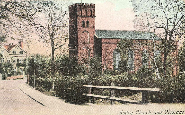
Adam Mort built Astley Chapel which was completed in 1630 and consecrated 3 August 1631. It was the first of three chapels in Astley, and the first chapel of ease of Leigh parish church.[38] Astley Chapel was rebuilt in 1760; Thomas Froggatt gave a contribution towards the cost.[39] The new church was built of brick and measured 54 feet 6 inches in length and 36 feet in width and held 170 people and was enlarged in 1834, 1842 and 1847. It had a small chancel and its embattled western tower contained a single bell.[2][40] The church, dedicated to St Stephen, was destroyed by arson on 18 June 1961. Also destroyed was the book collection, acquired by the Morts, memorials to the old families and the First and Second World War memorials. It was too severely damaged to restore and a third church has been built on a nearby site.[41]
Prominent Roman Catholic families in the Leigh parish did not abandon the old religion after the Reformation despite penalties levied on papists. Secret masses were held in private homes, including Morleys Hall, home of the Tyldesleys. On Easter Sunday 1641, the Romanist priest, Ambrose Barlow was arrested during a service at Morleys Hall at the instigation of the vicar of Leigh. He was taken to Lancaster Castle, tried as a traitor and executed on 10 September 1641.[42][43] He was canonised by the Roman Catholic Church as one of the Forty Martyrs of England and Wales.[44] A church and school bear his name.[44]
There were two Methodist churches but one in Lower Green closed in 2009.[45][46] Astley Unitarian Chapel was demolished and the site built on. Gin Pit School doubled as a chapel for Wesleyan Methodists.
Sport
Astley and Tyldesley Miners' Welfare Club at Gin Pit is the venue for several sporting groups including Astley and Tyldesley Football Club, Astley and Tyldesley Cricket Club[47] and the Astley and Tyldesley Roadrunners.[48] The Astley and Tyldesley Cycle Speedway Club was formed in 1989 and built a race track at the Miners' Welfare Club in 1991.[49]
Outside links
| ("Wikimedia Commons" has material about Astley, Lancashire) |
- The Astley Green Colliery Museum
- Pennine Waterways Virtual Cruise Astley Green to Worsley
- Pennine Waterways Virtual Cruise Leigh to Astley Green
- www.tyldesleyhistoricalsociety.co.uk, the Tyldesley Historical Society
- History of Astley Green Coal Mine
- Mort Family
References
- ↑ 1.0 1.1 Mills 1998, p. 10
- ↑ 2.0 2.1 2.2 2.3 [1] A History of the County of Lancaster - Volume pp 445–449: {{{2}}} (Victoria County History)
- ↑ Newsletter 71, wiganarchsoc.co.uk, http://www.wiganarchsoc.co.uk/content/News_Letters/news071.htm, retrieved 11 February 2010
- ↑ Mills 1998, p. 405
- ↑ Tonge 2002, p. 6
- ↑ Lunn 1968, p. 7
- ↑ Lunn 1968, p. 15
- ↑ Lunn 1968, p. 31
- ↑ 9.0 9.1 9.2 Tonge 2002, p. 5
- ↑ 10.0 10.1 National Heritage List 1163258: Administration block at Astley Hospital
- ↑ Tonge 2002, p. 11
- ↑ Tonge 2002, p. 13
- ↑ Tonge 2002, p. 14
- ↑ Tonge 2002, p. 20
- ↑ 15.0 15.1 Tonge 2002, p. 25
- ↑ Dam House, Mort's Astley Heritage Trust, archived from the original on 10 March 2012, https://web.archive.org/web/20120310114715/http://www.damhouse.net/damhouse-house-history, retrieved 19 September 2012
- ↑ Lunn 1968, p. 76
- ↑ NW Division map, cmhrc.co.uk, archived from the original on 19 July 2011, https://web.archive.org/web/20110719174541/http://www.cmhrc.co.uk/site/maps/lnw_map1.html, retrieved 19 September 2009
- ↑ Lunn 1968, p. 90
- ↑ 20.0 20.1 agcm, agcm.org.uk/, http://www.agcm.org.uk/, retrieved 4 August 2009
- ↑ (PDF) Astley Green Colliery Disaster, cmhrc.co.uk, p. 1, archived from the original on 13 June 2010, https://web.archive.org/web/20100613012206/http://www.cmhrc.co.uk:80/cms/document/1939_42.pdf, retrieved 17 November 2009
- ↑ National Heritage List 1068445: Astley Green Museum Winding Tower
- ↑ National Heritage List 1163357: Astley Green Mining Museum Winding House, Higher Green
- ↑ Spatial Portrait, limehouse.co.uk, http://wigan.limehouse.co.uk/portal/pp/core_strategy/csio?pointId=1198081730885, retrieved 29 December 2009
- ↑ Historic Environment, Wigan MDC, archived from the original on 13 March 2008, https://web.archive.org/web/20080313185018/http://www.wigan.gov.uk/Services/Environment/HistoricEnvironment/HeritageSites.htm, retrieved 18 February 2010
- ↑ Lunn 1968, p. 5
- ↑ National Heritage List 1318255: Morley's Hall
- ↑ Bond, Ackers & Ward 1979, p. 26
- ↑ (pdf) Gravelines Poor Clares, Queen Mary University of London, pp. 4–5, http://www.history.qmul.ac.uk/wwtn/pdfs/GravelinesPoorClares.pdf, retrieved 29 December 2010
- ↑ Sir Thomas Tyldesley, Peter J Tyldesley, http://www.peterjtyldesley.com/tyldesley/index.html, retrieved 2 February 2010
- ↑ Lunn 1968, p. 104
- ↑ 32.0 32.1 Lunn 1968, p. 73
- ↑ Lunn 1968, p. 95
- ↑ Lunn 1968, pp. 65–66
- ↑ Astley Station, subbrit.org, http://www.subbrit.org.uk/sb-sites/stations/a/astley/index.shtml, retrieved 11 May 2009
- ↑ Sweeney 1997, p. 333
- ↑ Three Lancashire Lowkas, IRSociety, http://www.irsociety.co.uk/Archives/10/three_lancashire_lowcas.htm, retrieved 18 September 2009
- ↑ Lunn 1968, p. 24
- ↑ Tonge 2002, p. 12
- ↑ Churches-UK-Ireland, churches-uk-ireland.org, http://www.churches-uk-ireland.org/images/manc/astley.jpg, retrieved 4 August 2009
- ↑ Lunn 1968, p. 107
- ↑ Lunn 1968, p. 30
- ↑ "Chorlton's canonised Catholic", BBC News, 9 November 2009, http://news.bbc.co.uk/local/manchester/hi/people_and_places/religion_and_ethics/newsid_8351000/8351281.stm, retrieved 23 January 2010
- ↑ 44.0 44.1 Bond, Ackers & Ward 1979, p. 28
- ↑ Manchester Road Independent Methodist, genuki.org.uk, http://www.genuki.org.uk/big/eng/LAN/Astley/ManchesterRoadIndependentMethodist.shtml, retrieved 10 December 2009
- ↑ Lower Green Lane Wesleyan Methodist, genuki.org.uk, http://www.genuki.org.uk/big/eng/LAN/Astley/LowerGreenLaneWesleyanMethodist.shtml, retrieved 10 December 2009
- ↑ A&T Cricket, play-cricket.com, http://astleytyldesley.play-cricket.com/home/home.asp, retrieved 24 January 2010Template:Dead link
- ↑ Astley Road Runners, astleyrunners.co.uk, archived from the original on 19 January 2010, https://web.archive.org/web/20100119002317/http://www.astleyrunners.co.uk/, retrieved 23 January 2010
- ↑ Cycle Speedway, astleycyclespeedway.org, archived from the original on 28 January 2010, https://web.archive.org/web/20100128053056/http://www.astleycyclespeedway.org.uk/, retrieved 23 January 2010
- Bond; Ackers; Ward (1979), Leigh Homesteads, Leigh Local History Society Publication No7
- Lunn, John (1968), A short history of the township of Astley, Lunn
- Mills, A.D. (1998), Dictionary of English Place-Names, Oxford, ISBN 0-19-280074-4
- Sweeney, D.J. (1997), A Lancashire Triangle Part Two, Triangle Publishing, ISBN 0-9529333-2-2
- Tonge, John & Sylvia (2002), Astley Hall Damhouse, John and Sylvia Tonge, ISBN 0-9515210-2-0