West Burton, Yorkshire
| West Burton | |
| Yorkshire North Riding | |
|---|---|
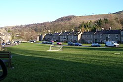
 West Burton village green | |
| Location | |
| Grid reference: | SE018870 |
| Location: | 54°16’45"N, 1°58’24"W |
| Data | |
| Population: | 303 (2011) |
| Post town: | Leyburn |
| Postcode: | DL8 4 |
| Local Government | |
| Council: | North Yorkshire |
| Parliamentary constituency: |
Richmond (Yorks) |
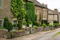
West Burton is a village in the North Riding of Yorkshire, sitting in Bishopdale, a side valley of Wensleydale, in the Yorkshire Dales. The village is found six miles to the south-west of Leyburn.
Name
The village is recorded in the Domesday Book as just Burton. The name of the village is derived from the Old English burhtun meaning a fortified farm.[1][2]
Until the 17th century the village was known as Burton in Bishopdale.[3] "West" distinguishes the village from the village of Constable Burton, nine miles to the east, also known simply as Burton in the early Middle Ages, and in the 19th century as Burton-in-Bishopdale.[4]
History
There is some evidence of an Iron Age settlement on top of nearby Burton Moor that has been designated a Scheduled Ancient Monument. It consists of about eighteen hut circles and defined fields.[5]
At the time of the Norman invasion the village was part of the manor belonging to Thorkil, but afterwards the manor was granted to Geoffrey of Swaffham by Count Alan of Brittany, who had been awarded the lands by the Crown.[6]
West Burton (or Burton in Bishopdale or Burton-cum-Walden) was a manor or township of the ancient parish of Aysgarth, and was always coupled with Walden.[3] The manor befell the same fate as other lands belonging to Geoffrey in that they eventually passed to Richard Duke of Gloucester in 1480. Thereafter the descent of the manor followed that of Castle Bolton into the 19th century.[3][7]
The village used to be an important market town and the octagonal market cross and stocks are still seen today on the village green.[7]
Churches
The Wesleyan and Independent Methodists both built chapels in the village in 1813 and 1851 respectively. The Wesleyan Methodist chapel was rebuilt in 1898.[7][3][8]
About the village
West Burton is within the Yorkshire Dales National Park. It stands lies near the mouth of Bishopdale and at the mouth of Waldendale, the valley through which Walden Beck runs. Walden Beck runs north past the eastern edge of the village to join Bishopdale Beck on its way to the River Ure.
Cauldron Falls (also called West Burton Falls) is a small waterfall in the village. It is only a short walk from the centre of the green.[9]
Outside links
| ("Wikimedia Commons" has material about West Burton, Yorkshire) |
References
- ↑ Watts (2011). Cambridge Dictionary of English Place-names. Cambridge University Press. pp. 104–5. ISBN 978-0521168557.
- ↑ Mills, Anthony David: 'A Dictionary of British Place-Names' (Oxford University Press, 2003) ISBN 978-0-19-852758-9
- ↑ 3.0 3.1 3.2 3.3 A History of the County of York: North Riding - Volume 1 pp 200-214: Parishes: Aysgarth (Victoria County History)
- ↑ London, Thomas (1889). "Aysgarth and its falls". in Smith, William. Old Yorkshire. London: Longmans Green. p. 270. OCLC 16114465.
- ↑ National Heritage List 1004064: Settlement on Burton Moor (Scheduled ancient monument entry)
- ↑ Burton West Burton, Yorkshire in the Domesday Book
- ↑ 7.0 7.1 7.2 Bulmer's Topography, History and Directory (Private and Commercial) of North Yorkshire 1890. S&N Publishing. 1890. p. 342. ISBN 1-86150-299-0.
- ↑ "Methodist Church". The Methodist Church. http://www.online.church123.com/northyorkshiredalesmethodistcircuit/westburton.htm.
- ↑ Coates, Neil (2012). Walks to waterfalls : walks to the best waterfalls in the Yorkshire Dales. Tattenhall: Northern Eye. p. 9. ISBN 978-1-908632-11-1.


