Steyning
| Steyning | |
| Sussex | |
|---|---|
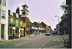
 High Street, Steyning Town Centre | |
| Location | |
| Grid reference: | TQ177110 |
| Location: | 50°53’12"N, 0°19’40"W |
| Data | |
| Population: | 5,812 (2001) |
| Post town: | Steyning |
| Postcode: | BN44 |
| Dialling code: | 01903 |
| Local Government | |
| Council: | Horsham |
| Parliamentary constituency: |
Arundel and South Downs |
Steyning stɛnɪŋ is a small, inland town in Sussex, standing at the north end of the River Adur gap in the South Downs, four miles north of Shoreham-by-Sea. The smaller villages of Bramber and Upper Beeding constitute, with Steyning, a built-up area at this crossing-point of the river.
Steyning is well equipped for a small town – it has local shops, four public houses, four estate agents and three banks. Furthermore, there is a state-of-the-art leisure centre.
A Spring Fair is held on the Spring bank holiday; the last Monday in May.
The Monarch's Way long-distance footpath skirts the southern end of the town.
Contents
Churches
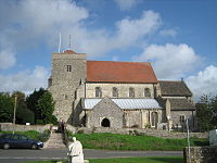
Churches in Steyning include its ancient parish church, St Andrew and St Cuthman.
Legend has it that St Cuthman built a church, at one time dedicated to him, later to St Andrew, and now jointly to St Andrew and St Cuthman and that it was built on the spot where he stopped after carrying his mother in a wheelbarrow. King Alfred the Great's father, Æthelwulf of Wessex, was originally buried in that church, before being transferred to Winchester, and an Anglo-Saxon grave slab (possibly his) remains in the church porch.
History
Saxon and Mediæval
Steyning has existed since Anglo-Saxon times. Its church is named from the legend of St Cuthman, who carried his mother here in a wheelbarrow, which is taken as a great feat of holiness (which rather presupposes something unfortunate about the lady's weight). Several of the signs that can be seen on entering Steyning bear an image of his feat.
Steyning was apparently the burial place of Æthelwulf, King of the West Saxons.
To thank his Norman protectors for refuge during his exile, Edward the Confessor granted his royal minster church in Steyning, with its large and wealthy manor lands, to the Abbey Church of the Holy Trinity at Fécamp, to take effect after the death of Aelfwine, the Bishop of Winchester, who had charge of Steyning. The bishop died in 1047 and ecclesiastical jurisdiction was assumed directly by the Pope, to whom alone Fécamp Abbey itself answered. Godwin, Earl of Wessex expelled the Norman monks in 1052 (a Norman presence on a strategic coastline would be uncomfortable) and seized Steyning for himself. William the Conqueror responded by swearing on a knife before setting out for England to recover it for the monks:
- Of the land of Steyning [county of Sussex]; the Duke gave seisin to the Church by the token of a knife, before he went to England; the grant to take effect if God should give him victory in England.
William the Conqueror confirmed King Edward's grant and gave the abbey extraordinary exemption from the jurisdiction of the authorities,[1] and the church also received the nearby port with land around Rye, Winchelsea and Hastings, already given to the Abbey by King Cnut. By then Steyning was already a thriving and important port with a market, a royal mint, Cuthman's church and one other church, as Domesday Book relates 60 years later.
The Abbey was still at a strategic place and William's grant undefined and William de Braose of Bramber Castle was embroiled in disputes with the Abbey, over boundaries, tolls demanded of ships bound for Steyning and the right to bury its parishioners (and the burial fees paid). The result was a court decision in 1086 by the King in person and his Curia Regis, in which the Abbey at Steyning won on many points against de Braose.
In the 14th century, the river Adur began to silt up and the town's use as a port became difficult leading to a loss of trade and population. The monks of Fécamp Abbey retained control of Steyning until the 15th century, and re-dedicated the church of St Cuthman to St Andrew in the 13th Century. Steyning began returning two Members of Parliament from 1278 and as a rotten borough made up of a depopulated port until the Reform Act 1832.
Modern period
The Abbey was dissolved under Henry VIII. In 1614, William Holland, Alderman of Chichester founded and endowed Steyning Grammar School.[1]
The railway from London to Shoreham arrived in Steyning in 1861 and a station was opened to serve the town.
The legendary Irish politician Charles Stewart Parnell married 'Kitty' O'Shea (niece of Lord Hatherley) here in 1891, the culmination of the affair that saw his fall from power, catastrophically dividing Irish politics.
Besides much agriculture, brewing and to a small extent brickmaking, more than 25 men were employed in the sheep related trade as fellmongers more than four were parchment makers, five were millers and there was a surgeon, an oil painter James M. Burfield R.A., R.B.A. (Exh.1880-1883) and a watch maker in the town during the 1881 census.
The railway remained in service for over a century, closing in 1966 as result of the Beeching Axe. The route of the railway line has since been converted into a footpath and cycleway known as the Downs Link. The nearest railway station to the town today is Shoreham-by-Sea.
Sport and leisure
- Football: Steyning Town FC, who play at The Shooting Field.
The town has its own leisure centre.
Outside links
| ("Wikimedia Commons" has material about Steyning) |
References
- ↑ From: Regesta Regum Anglo-Normannorum 1066-1154 Volume I, edited by H W C Davis (Oxford, 1913)
- 'Steyning', A History of the County of Sussex: Volume VI Part 1: Bramber Rape (Southern Part) (1980), pp. 220–26
- Horsham District Council - Parish Population Estimates


