Difference between revisions of "St Michael's Mount"
(→Outside links) |
m |
||
| Line 6: | Line 6: | ||
|picture caption=St Michael's Mount | |picture caption=St Michael's Mount | ||
|os grid ref=SW514299 | |os grid ref=SW514299 | ||
| + | |latitude=50.117 | ||
| + | |longitude=-5.4788 | ||
|area=115 acres | |area=115 acres | ||
|website=http://www.stmichaelsmount.co.uk/ | |website=http://www.stmichaelsmount.co.uk/ | ||
Latest revision as of 19:17, 25 January 2024
| St Michael's Mount Cornish: Karrek Loes y'n Koes | |
 St Michael's Mount | |
|---|---|
| Location | |
| Location: | 50°7’1"N, 5°28’44"W |
| Grid reference: | SW514299 |
| Area: | 115 acres |
| Data | |
| Website: | http://www.stmichaelsmount.co.uk/ |
St Michael's Mount is a tidal island 400 yards off the coast of Cornwall, in Mount's Bay. It is sufficiently inhabited to have been constituted a civil parish, if one chaired by the owner. The island is joined to the town of Marazion by a man-made causeway of granite setts, passable only at low tide.
The island exhibits a combination of slate and granite. Its Cornish language name literally means "the grey rock in the wood" and may represent a folk memory of a time before Mount's Bay was flooded. Certainly, the Cornish name would be an accurate description of the Mount set in woodland. Remains of trees have been seen at low tides following storms on the beach at Perranuthnoe, but radiocarbon dating established the submerging of the hazel wood at about 1700 BC.[1]
Contents
History

The Mount is often claimed to be the island of Mictis named by Timaeus and mentioned by Pliny the Elder,[2] and the Ictis of Pytheas in the fourth century BC, who reports that Ictis was an island on the south coast of Britain, joined to the mainland at low tide, and that at low tide the Britons carried tin to the island for sale to foreign merchants. However, there is ample evidence that St Michael's Mount became an island only in the early Middle Ages, and Barry Cunliffe proposes that Ictis was Mount Batten in Plymouth.[3]
The chronicler John of Worcester[4] relates under the year 1099 that St Michael's Mount was located five or six miles from the sea, enclosed in a thick wood, but that on the third day of the nones of November the sea overflowed the land, destroying many towns and drowning many people as well as innumerable oxen and sheep. The Anglo-Saxon Chronicle records under the date 11 November 1099, "The sea-flood sprung up to such a height, and did so much harm, as no man remembered that it ever did before".[5]
In the fifth century A.D., it is claimed that St Michael, the Archangel appeared to local fishermen on the Mount,[6] which according to author Richard Freeman Johnson is perhaps a nationalistic twist to a myth.[7]
It may have been the site of a monastery in the 8th - early 11th centuries. In the eleventh century King Edward the Confessor gave the mount to the Norman Benedictine abbey of Mont Saint-Michel,[8] which lies south across the English Channel and is likewise an island joined to the mainland at low tide.[9] It may be that the island took its current name at that time, from its new mother-house.
The monastic buildings on St Michael's Mount were built during the 12th century. It remained a priory of Mont Saint-Michel until 1425, at the dissolution of the alien houses by Henry V,[10] and it was given to the Abbess and Convent of Syon at Isleworth, Middlesex. The Mount was a resort of pilgrims, whose devotions were encouraged by an indulgence granted by Pope Gregory in the 11th century.
At some point in the Middle Ages, an anchorite cell was established on the Mount; in the late 19th century the skeleton of an anchorite was discovered in a chamber found beneath the castle's chapel. When he died, the chamber had been sealed off to become his tomb.
In the reign of King Richard I, Henry Pomeroy captured the Mount, on behalf of Prince John. In 1473, John de Vere, 13th Earl of Oxford, seized the Mount and held it during a siege of 23 weeks against 6,000 of Edward IV's troops. In 1497, Perkin Warbeck's men occupied the Mount. In the Prayer Book Rebellion of 1549, Humphry Arundell, Governor of St Michael's Mount, led the Cornish rebels.
During the reign of Queen Elizabeth I, the mount was given to Robert Cecil, later Earl of Salisbury, by whose son it was sold to Sir Francis Basset. During the Civil War, Sir Arthur Basset, brother of Sir Francis, held the Mount against the parliamentary forces until July 1646.

The Mount was sold in 1659 to Colonel John St Aubyn. His descendant, Lord St Levan, continues to be the "tenant" of the Mount but has ceased to be resident there, his nephew, James St Aubyn, taking up residency and management of the Mount in 2004.
In 1755 the Lisbon earthquake caused a tsunami to strike the Cornish coast over 1000 miles away. The sea rose six feet in 10 minutes at St Michael's Mount, ebbed at the same rate, and continued to rise and fall for five hours. The 19th-century French writer Arnold Boscowitz claimed that "great loss of life and property occurred upon the coasts of Cornwall." [11]
Little is known about the village on the island before the beginning of 18th century, save that there were a few fishermen's cottages and monastic cottages. After improvements to the harbour in 1727, St Michael's Mount became a flourishing seaport, and by 1811 there were 53 houses and four streets. The population peaked in 1821, when the island had 221 inhabitants. There were three schools, a Wesleyan chapel, and three public houses, mostly used by visiting sailors. The village went into decline following major improvements to nearby Penzance harbour and the extension of the railway to Penzance in 1852, and many of the houses and buildings were demolished.
The Mount was fortified during the Second World War during the invasion crisis of 1940-41. Three pillboxes can be seen to this day.
Sixty-five years after the Second World War, it was suggested based on interviews with contemporaries that the former Nazi foreign minister and one time ambassador to Britain, Joachim von Ribbentrop, had wanted to live on the Mount after the planned German conquest. Archived documents revealed that during his time in Britain in the 1930s, in which he had initially proposed an alliance with Nazi Germany, Ribbentrop frequently visited Cornwall.[12]
In 1954, Francis St Aubyn, the third Lord St Levan, gave most of St Michael's Mount to the century National Trust, along with a large endowment fund for its upkeep. Lord St Leven retained a 999-year lease for the family to live in the castle and a licence to show the historical rooms to the visiting public.
The island today

The chapel is extra-diocesan, and the castle is the official residence of Lord St Levan. Many relics, chiefly armour and antique furniture, are preserved in the castle. The chapel of St Michael, a fifteenth century building, has an embattled tower, in one angle of which is a small turret, which served for the guidance of ships. Chapel Rock, on the beach, marks the site of a mediæval shrine that was dedicated to the Virgin Mary, where pilgrims paused to worship before ascending the Mount. A few houses are built on the hillside facing Marazion, and a spring supplies them with water.
St Michael's Mount now belongs to the National Trust, but Lord St Leven owns the castle on a 999-year lease from the Trust. The St Aubyn family continue to live on and manage the island, as they have done since the middle of the 17th century.

There is a row of eight houses at the back of the present village; they were built in 1885 and are known as Elizabeth Terrace. A spring supplies them with water. Some of the houses are occupied by staff working in the castle and elsewhere on the island.
The island cemetery (currently no public access) contains the graves of former residents of the island and several drowned sailors. There are also buildings that were formerly the steward's house, a changing-room for bathers, the stables, the laundry, a barge house, a sail loft (now a restaurant), and two former inns. A former bowling green adjoins one of the buildings.
One of the most noteworthy points of interest on the island is the island's own underground railway, which is still used to transport goods from the harbour up to the castle. It was built by tin miners around 1900, replacing the pack horses which had previously been used. Due to the steep gradient, it cannot be used for passengers. The National Trust currently does not permit public access or viewing of the railway.
The harbour, widened in 1823 to allow vessels of 500 tons to enter, has a pier dating from the fifteenth century which was subsequently enlarged and restored. Queen Victoria landed at the harbour from the royal yacht in 1846, and a brass inlay of her footstep can be seen at the top of the landing stage. King Edward VII's footstep is also visible near the bowling-green. In 1967 the Queen Mother entered the harbour in a pinnace from the Royal Yacht Britannia.
Geology
The rock exposures around St Michael's Mount provide an opportunity to see many features of the geology of Cornwall in a single locality.[13] The mount is made of the uppermost part of a granite intrusion into metamorphosed Devonian mudstones or pelites. The granite is itself mineralised with a well-developed sheeted greisen vein system.
Due to its geology the southern coast of the island was designated a Site of Special Scientific Interest in 1995.[14]
In popular culture
St Michael's Mount was used in the 1979 film Dracula as Castle Dracula and also in the 2003 film Johnny English as the exterior of the character Pascal Sauvage's French chateau.
In the 1983 James Bond film Never Say Never Again, two guided missiles armed with nuclear warheads fly over the English countryside and out to sea, passing directly over St Michael's Mount.
In Michael Moorcock's series of Fantasy novels about Prince Corum, a fictionalised version of St Michael's Mount appears as Moidel's Mount.
Pictures
St Michael's Mount.

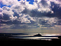
Sunset, St Michael's Mount.

St Michael's Mount.
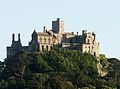
The Castle
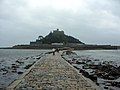
The causeway at low tide.
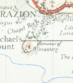
A map from 1946

Sunrise over Mount's Bay


Outside links
| ("Wikimedia Commons" has material about St Michael's Mount) |
- St Michael's Mount - information at the National Trust
- St Michael's Mount website
- St Michael's Mount Garden — information on garden history
- Pliny: Naturalis Historia (IV:XVI.102-4)
- Cornwall Record Office Online Catalogue for St Michael's Mount
- National Heritage List 1143795: St Michael's Mount (Grade I listing)
References
- ↑ Gavin de Beer, "Iktin", The Geographical Journal 126.2 (June 1960:160-167), esp. p. 163.
- ↑ Naturalis Historia (IV:XVI.104) by Pliny the Elder
- ↑ Cunliffe, Barry: Ictis – Is it here? Oxford Journal of Archaeology, Vol2, March 1983
- ↑ Noted by de Beer 1960:162f as "Florence of Worcester" in Thomas Forester's edition, London, 1854:206.
- ↑ Anglo-Saxon Chronicle Laud Chronicle (1099)
- ↑ Stmichaelsmount.co.uk
- ↑ Saint Michael the Archangel in mediæval English legend by Richard Freeman Johnson, 2005 ISBN 1843831287 page 68
- ↑ Cornish Church Guide (1925) Truro: Blackford; pp. 159-62
- ↑ Pevsner, N. (1970) Cornwall, 2nd ed. Penguin Books; pp. 193-195
- ↑ Pevsner, N. (1970) Cornwall, 2nd ed. Penguin Books; pp. 193-195
- ↑ Sources of Cornish History — The Lisbon Earthquake
- ↑ Thorpe, Vanessa (3 October 2010). "Nazi foreign minister planned to retire in Cornwall". The Observer (guardian.co.uk). http://www.guardian.co.uk/world/2010/oct/03/nazi-foreign-minister-planned-cornwall-retirement. Retrieved 11 January 2011.
- ↑ Camborne School of Mines, Virtual Museum of the Cornubian Orefield, virtual geological field excursion, Marazion to Porthleven
- ↑ "St Michael's Mount". Natural England. 1995. http://www.sssi.naturalengland.org.uk/citation/citation_photo/2000121.pdf. Retrieved 28 October 2011.
Books
- Foot, William (2006). Beaches, fields, streets, and hills ... the anti-invasion landscapes of England, 1940. Council for British Archaeology. ISBN 1-902771-53-2.