Oulton, Staffordshire
| Oulton | |
| Staffordshire | |
|---|---|
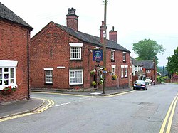
 The Brickmakers Arms, Oulton | |
| Location | |
| Grid reference: | SJ909356 |
| Location: | 52°55’7"N, 2°8’10"W |
| Data | |
| Post town: | Stone |
| Local Government | |
| Council: | Stafford |
Oulton is a small village in Staffordshire, sitting just north of the market town of Stone on a little river, the Scotch Brook, which once provided the power for several mills, and which runs down to the River Trent and the Trent and Mersey Canal in Stone.
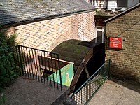
The brook carves out the Moddershall Valley, in which Oulton stands. The geography of the area is defined by the brook and the canal: the Scotch Brook is a short river, which runs west from the village of Moddershall then south and southwest to the Trent. During the 18th century Industrial Revolution, Scotch Brook became the most intensively exploited waterway in Staffordshire, with nine flint-grinding mills located in the valley in total, and three within the confines of Oulton village.
The entire Moddershall Valley is now part of a designated Conservation Area.[1]
This is a well-to-do village; Oulton and Oulton Heath are considered to be populated by professional families, affluent individuals and a retiree community towards the heart of the village. The natural landscape and proximity to Stone contribute to high property prices relative to the surrounding area.
Outside links
| ("Wikimedia Commons" has material about Oulton, Staffordshire) |
References
- ↑ Staffordshire County Council: Moddershall Valley- Conservation Area, designation No.76, 1987
