Difference between revisions of "Newnham, Hertfordshire"
From Wikishire
(Created page with '{{Infobox town |name=Newnham |county=Hertfordshire |picture=Houses in Newnham - geograph.org.uk - 48987.jpg |picture caption=Houses in Newnham |os grid ref=TL245375 |latitude=52.…') |
|||
| (One intermediate revision by the same user not shown) | |||
| Line 10: | Line 10: | ||
|LG district= | |LG district= | ||
}} | }} | ||
| − | '''Newnham''' is a small village near [[Ashwell, Hertfordshire|Ashwell]] in [[Hertfordshire]]. It has about 100-200 inhabitants. It shares a parish (and civil parish) with nearby [[Caldecote]]. | + | '''Newnham''' is a small village near [[Ashwell, Hertfordshire|Ashwell]] in [[Hertfordshire]]. It has about 100-200 inhabitants. It shares a parish (and civil parish) with nearby [[Caldecote, Hertfordshire|Caldecote]]. The [[Hertfordshire Border Walk]] runs through both. |
The parish church is St Vincent's, which has several surviving mediæval wall paintings. | The parish church is St Vincent's, which has several surviving mediæval wall paintings. | ||
Latest revision as of 18:09, 17 January 2024
| Newnham | |
| Hertfordshire | |
|---|---|
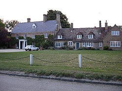
 Houses in Newnham | |
| Location | |
| Grid reference: | TL245375 |
| Location: | 52°1’19"N, 0°11’13"W |
| Data | |
| Local Government | |
Newnham is a small village near Ashwell in Hertfordshire. It has about 100-200 inhabitants. It shares a parish (and civil parish) with nearby Caldecote. The Hertfordshire Border Walk runs through both.
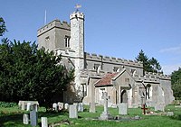
The parish church is St Vincent's, which has several surviving mediæval wall paintings.
Outside links
| ("Wikimedia Commons" has material about Newnham, Hertfordshire) |
