Difference between revisions of "Market Drayton"
(Created page with '{{Infobox town |name=Market Drayton |county=Shropshire |picture=MarketDraytonTudorHouseHotel.jpg |picture caption=Tudor House Hotel |os grid ref=SJ673321 |latitude=52.9044 |longi…') |
|||
| Line 14: | Line 14: | ||
|constituency=North Shropshire | |constituency=North Shropshire | ||
}} | }} | ||
| − | '''Market Drayton''' is a small market town in northern [[Shropshire]]. It stands on the [[River Tern]], between [[Shrewsbury]] and [[Stoke-on-Trent]] | + | '''Market Drayton''' is a small market town in northern [[Shropshire]], right against the border with [[Staffordshire]]. It stands on the [[River Tern]], which here forms the county border, between [[Shrewsbury]] and [[Stoke-on-Trent]]. It was formerly known as "'''Drayton in Hales'''" (1868) and earlier simply as "'''Drayton'''" (1695). |
| − | Market Drayton is on the Shropshire Union Canal and on Regional Cycle Route 75. The A53 road by-passes the town. | + | Market Drayton is on the [[Shropshire Union Canal]] and on Regional Cycle Route 75. The A53 road by-passes the town. |
==Industry== | ==Industry== | ||
| Line 28: | Line 28: | ||
Other notable landmarks in the area include: Pell Wall Hall, Adderley Hall, Buntingsdale Hall, Salisbury Hill, Tyrley Locks on the Shropshire Union Canal and the Thomas Telford designed aqueduct. | Other notable landmarks in the area include: Pell Wall Hall, Adderley Hall, Buntingsdale Hall, Salisbury Hill, Tyrley Locks on the Shropshire Union Canal and the Thomas Telford designed aqueduct. | ||
| − | Fordhall Farm, consists of 140 acres of community-owned organic farmland off the A53. The farm trail is open to the public during farm shop opening hours, and included along the path is the site of an ancient motte and bailey structure which overlooks the [[River Tern]] valley. | + | Fordhall Farm, consists of 140 acres of community-owned organic farmland off the A53. The farm trail is open to the public during farm shop opening hours, and included along the path is the site of an ancient motte-and-bailey structure which overlooks the [[River Tern]] valley. |
To the south-east near the A529 an eighteenth-century farmhouse stands on the site of '''Tyrley Castle''', which was probably built soon after 1066 and later rebuilt in stone in the thirteenth century. | To the south-east near the A529 an eighteenth-century farmhouse stands on the site of '''Tyrley Castle''', which was probably built soon after 1066 and later rebuilt in stone in the thirteenth century. | ||
| Line 36: | Line 36: | ||
<gallery> | <gallery> | ||
File:DraytonViaduct.JPG|Aqueduct | File:DraytonViaduct.JPG|Aqueduct | ||
| − | File:DraytonStMarys.JPG|St | + | File:DraytonStMarys.JPG|St Mary's Church |
| − | File:StMary's, Market Drayton-geograph-771033-by-Geoff-Pick.jpg|St | + | File:StMary's, Market Drayton-geograph-771033-by-Geoff-Pick.jpg|St Mary's Church |
File:DraytonLocks.JPG|Tyrley Locks | File:DraytonLocks.JPG|Tyrley Locks | ||
File:PellWall.jpg|Pell Wall Hall | File:PellWall.jpg|Pell Wall Hall | ||
| Line 43: | Line 43: | ||
==Outside links== | ==Outside links== | ||
| − | *[http://www.stmarysmarketdrayton.org.uk St | + | *[http://www.stmarysmarketdrayton.org.uk St Mary's Church] |
*[http://www.mdmc.org.uk Market Drayton Methodist Church] | *[http://www.mdmc.org.uk Market Drayton Methodist Church] | ||
*[http://www.shropshiretourism.info/ Shropshire Tourism] The official tourism website for Shropshire | *[http://www.shropshiretourism.info/ Shropshire Tourism] The official tourism website for Shropshire | ||
Latest revision as of 08:10, 3 August 2017
| Market Drayton | |
| Shropshire | |
|---|---|
 Tudor House Hotel | |
| Location | |
| Grid reference: | SJ673321 |
| Location: | 52°54’16"N, 2°29’5"W |
| Data | |
| Population: | 10,407 |
| Post town: | Market Drayton |
| Postcode: | TF9 |
| Dialling code: | 01630 |
| Local Government | |
| Council: | Shropshire |
| Parliamentary constituency: |
North Shropshire |
Market Drayton is a small market town in northern Shropshire, right against the border with Staffordshire. It stands on the River Tern, which here forms the county border, between Shrewsbury and Stoke-on-Trent. It was formerly known as "Drayton in Hales" (1868) and earlier simply as "Drayton" (1695).
Market Drayton is on the Shropshire Union Canal and on Regional Cycle Route 75. The A53 road by-passes the town.
Industry
The biggest employment in Market Drayton comes from food. In 1965, sausage maker Palethorpe's built a new factory employing 400 people in the town and though changing hands a number of time, the factory remains open to this day as the town's largest employer. Müller Dairies have a factory making yoghurts. On the smaller side, Image on Food makes local gingerbread.
Sites of Interest
The great fire of Drayton destroyed almost 70% of the town in the 17th century. It was started at a bakery, and quickly spread through the timber buildings. The Buttercross in the centre of the town still has a bell at the top for townsfolk to ring if there were ever another fire.
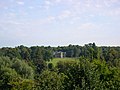
Ancient local sites include: Audley's Cross, Blore Heath, and several Neolithic standing stones, "The Devil's Ring and Finger", just three miles from the town.
Other notable landmarks in the area include: Pell Wall Hall, Adderley Hall, Buntingsdale Hall, Salisbury Hill, Tyrley Locks on the Shropshire Union Canal and the Thomas Telford designed aqueduct.
Fordhall Farm, consists of 140 acres of community-owned organic farmland off the A53. The farm trail is open to the public during farm shop opening hours, and included along the path is the site of an ancient motte-and-bailey structure which overlooks the River Tern valley.
To the south-east near the A529 an eighteenth-century farmhouse stands on the site of Tyrley Castle, which was probably built soon after 1066 and later rebuilt in stone in the thirteenth century.
Many of the streets in the town are named after famous castles, such as Balmoral Drive, Caernavon Close, Windsor Drive, Warwick Close, and many others.
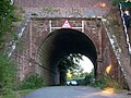
Aqueduct
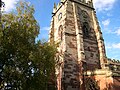
St Mary's Church
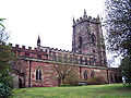
St Mary's Church
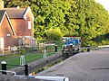
Tyrley Locks
Pell Wall Hall


Outside links
- St Mary's Church
- Market Drayton Methodist Church
- Shropshire Tourism The official tourism website for Shropshire
- Market Drayton Council
- Market Drayton Tigers Junior Football Club
- TF9 Online - Community site for the Market Drayton area
- The Phoenix Badminton Club
- Market Drayton on Pictures of England