Difference between revisions of "Llanlleiana"
(Created page with "{{Infobox town |name=Llanlleiana |county=Anglesey |picture=Llanlleiana - geograph.org.uk - 3739417.jpg |picture caption= |os grid ref= SH386947 |latitude=53.42479 |longitude=-...") |
|||
| Line 17: | Line 17: | ||
'''Llanlleiana''' is a tiny hamlet close by the northernmost point of [[Anglesey]], in the parish of [[Llanbadrig]]. Its name is from the Welfsh for 'Church of Nuns': the Nunnery stood on a ridge at the entrance of the inlet. A portion of the church wall is still standing.<ref name=Richards>[http://www.penmorfa.com/porthwen/notes_from_1923.htm Notes by the Rev. W Richards in "Guide Book to Cemaes Bay and District"] (1923)</ref> | '''Llanlleiana''' is a tiny hamlet close by the northernmost point of [[Anglesey]], in the parish of [[Llanbadrig]]. Its name is from the Welfsh for 'Church of Nuns': the Nunnery stood on a ridge at the entrance of the inlet. A portion of the church wall is still standing.<ref name=Richards>[http://www.penmorfa.com/porthwen/notes_from_1923.htm Notes by the Rev. W Richards in "Guide Book to Cemaes Bay and District"] (1923)</ref> | ||
| − | There is small inlet here, Porth Llanlleiana, not of any use for boats nor frequented by bathers, but the [[Anglesey | + | There is small inlet here, Porth Llanlleiana, not of any use for boats nor frequented by bathers, but the [[Anglesey Coastal Path]] runs by it. [[Llanlleiana Head]] is the northernmost point of Anglesey's main island, and a few hundred yards out to see off the head is [[Middle Mouse]], the northernmost point of the county, and of [[Wales]]. Llanlleiana is the [[Extreme points of the United Kingdom|northernmost settlement of Wales]]. |
[[File:Llanlleiana porcelain works - geograph.org.uk - 3179503.jpg|left|thumb|200px|Llanlleiana Porcelain Works]] | [[File:Llanlleiana porcelain works - geograph.org.uk - 3179503.jpg|left|thumb|200px|Llanlleiana Porcelain Works]] | ||
Latest revision as of 09:31, 24 March 2024
| Llanlleiana | |
| Anglesey | |
|---|---|

| |
| Location | |
| Grid reference: | SH386947 |
| Location: | 53°25’29"N, 4°25’47"W |
| Data | |
| Postcode: | LL67 |
| Local Government | |
| Council: | Anglesey |
| Parliamentary constituency: |
Ynys Môn |
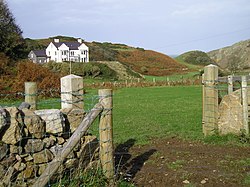
Llanlleiana is a tiny hamlet close by the northernmost point of Anglesey, in the parish of Llanbadrig. Its name is from the Welfsh for 'Church of Nuns': the Nunnery stood on a ridge at the entrance of the inlet. A portion of the church wall is still standing.[1]
There is small inlet here, Porth Llanlleiana, not of any use for boats nor frequented by bathers, but the Anglesey Coastal Path runs by it. Llanlleiana Head is the northernmost point of Anglesey's main island, and a few hundred yards out to see off the head is Middle Mouse, the northernmost point of the county, and of Wales. Llanlleiana is the northernmost settlement of Wales.
There was once a porcelain works at Llanlleiana, working on the clays of Dinas Morfa. It is now left as an abandoned ruin.[2][1]

