Isle of Wight
| Isle of Wight | |
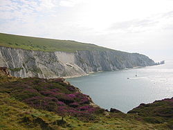 The Needles and Alum Bay | |
|---|---|
| Main town: | Newport |
| Location | |
| Area: | 148 sq miles |
| Data | |
| Population: | 140,000 |
The Isle of Wight is an island of Hampshire in the English Channel, 3–5 miles off the south coast of Great Britain. It is separated from the main body of Hampshire by a strait called the Solent. The island is known for its natural beauty, its sailing based at the town of Cowes, and its resorts, which have been holiday destinations since Victorian days.
The island has a rich history, including a brief status as a dependent kingdom in the 15th century. Until 1995, the island had its own Governor, holding a position similar to that of lord-lieutenants elsewhere, a position held by many distinguished military men, most notably Lord Mountbatten from 1969–1974.
It was home to the poet Alfred Lord Tennyson, and to Queen Victoria, who built her much loved summer residence and final home Osborne House at East Cowes. The island's maritime and industrial history encompasses boat building, sail making, the manufacture of flying boats, the world's first hovercraft and the testing and development of Britain's space rockets. It is home to the Isle of Wight International Jazz Festival and the recently-revived Isle of Wight Festival, which, in 1970, was the largest rock music event ever held.[1] The island has some exceptional wildlife and is one of the richest locations of dinosaur fossils in Europe.
Wight had 132,731 permanent residents according to the 2001 census (making it the most populous Parliamentary constituency in the United Kingdom.
The island is easily accessible from Southsea by hovercraft and by several ferry services from Southampton to Cowes (10 miles), Portsmouth to Ryde (5 miles), Portsmouth to Fishbourne (7 miles) and Lymington to Yarmouth (4 miles).
Physical geography and wildlife
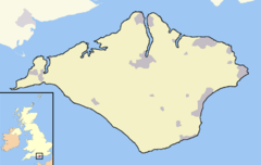
The Isle of Wight is approximately diamond-shaped and covers an area of 148 square miles. Slightly more than half of the island, mainly in the west, is designated as the “Isle of Wight Area of Outstanding Natural Beauty”. The landscape of the Island is remarkably diverse, leading to its oft-quoted description of "England in Miniature". West Wight is predominantly rural, with dramatic coastlines dominated by the famous chalk downland ridge, running across the whole island and ending in The Needles stacks — perhaps the most photographed aspect of the Isle of Wight. The highest point on the island is St Boniface Down.
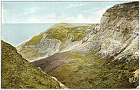
The rest of the Island's landscape also has great diversity, with perhaps the most notable habitats being the soft cliffs and sea ledges, which are spectacular features as well as being very important for wildlife, and are internationally protected. The River Medina flows north into the Solent, whilst the other main river, the River Yar flows roughly north-east, emerging at Bembridge Harbour at the eastern end of the island. Confusingly, there is another entirely separate river at the western end also called the River Yar flowing the short distance from Freshwater Bay to a relatively large estuary at Yarmouth. To distinguish them, they may be referred to as the Eastern and Western Yar.
The south coast of the island borders the English Channel. Without man's intervention, the sea might well have split the island into three; at the west end where a bank of pebbles separates Freshwater Bay from the marshy backwaters of the Western Yar east of Freshwater, and at the east end where a thin strip of land separates Sandown Bay from the marshy basin of the Eastern Yar, east of Sandown. Yarmouth itself was effectively an island, with water on all sides and only connected to the rest of the island by a regularly breached neck of land immediately east of the town.
Island wildlife is remarkable, and it is one of the few places in England where the red squirrel is flourishing, with a stable population (Brownsea Island in Dorset is another). Unlike most of Britain, no grey squirrels are to be found on the island,[2] nor are there any wild deer. Instead, rare and protected species such as the dormouse and many rare bats can be found. The Glanville Fritillary butterfly's distribution in the United Kingdom is largely restricted to the edges of the crumbling cliffs of the Isle of Wight.
The island is known as one of the most important areas in Europe for dinosaur fossils. The eroding cliffs often reveal previously hidden remains.
Geology
The Isle of Wight is made up of a wide variety of different rock types ranging from Early Cretaceous times (around 127 million years ago) to the middle of the Palaeogene (around 30 million years ago). All the rocks found on the island are sedimentary, made up of mineral grains from previously existing rocks. These are all consolidated to form the rocks that can be seen on the island today, such as limestone, mudstone and sandstone. Rocks on the island are very rich in fossils and many of these can be seen exposed on the beaches as the cliffs erode.
Cretaceous rocks on the island, usually red, show that the climate was previously hot and dry. This provided suitable living conditions for dinosaurs. Dinosaur bones and footprints can be seen in and on the rocks exposed around the island's beaches, especially at Yaverland and Compton Bay. As a result, the isle has been nicknamed Dinosaur Island.
Along the northern coast of the island there is a rich source of fossilised shellfish, crocodiles, turtles and mammal bones. The youngest of these date back to around 30 million years ago.
The island is mainly made up of Tertiary clays, in most of the northern parts of the island, limestone, upper and lower greensands, wealden and chalk.
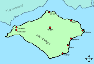
Main towns
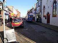
- Newport, located in the centre of the island, is the administrative centre of the Isle of Wight and is the island's main shopping area. Recent developments include a new bus station with retail complex and a new retail park on the outskirts. Located next to the River Medina, Newport Quay was a busy port until the mid 19th century, but has now been mainly converted into art galleries, apartments and other meeting places.
- Ryde, the island's largest town with a population of around 30,000, is located in the north east of the island. It is a Victorian town with an 800 yard long pier and 4 miles of beaches, attracting many tourists each year. Every year there is a Ryde Carnival in two parts, spread over more than one day: one in the daytime, and one at night with many coloured lights. Ryde is also home to the ice hockey club Isle of Wight Raiders, who play in the English Premier League.
- Cowes is the location of Cowes Week every year and a popular international sailing centre. It is also the home of the record-setting sailor Dame Ellen MacArthur.
- Sandown is another seaside resort, attracting many tourists each year. It is also home to the Isle of Wight Zoo and Dinosaur Isle geological museum, and one of the island's two 18-hole golf courses.
- Shanklin just south of Sandown, also attracts tourists, with its sandy beaches, Shanklin Chine and the old village.
- Ventnor, built on the steep slopes of St Boniface Down on the south coast of the island, leads down to a picturesque bay that attracts many tourists. Recent developments include Ventnor Haven, a small harbour built around a Victorian-style bandstand.

In addition there are smaller towns along the coasts, particularly on the eastern side of the island. There are also a number of smaller villages. Some of these (for example, Godshill) also attract many tourists.
References
- ↑ "Isle of Wight Festival history". Redfunnel.co.uk. http://www.redfunnel.co.uk/island-guide/isle-of-wight-music-festivals-and-concerts/isle-of-wight-festival/iow-festival-history. Retrieved 2010-09-25.
- ↑ "Operation Squirrel". Iwight.com. http://www.iwight.com/living_here/environment/operation_squirrel.asp. Retrieved 2010-09-25.
Outside links
- Isle of Wight Guide
- Island Eye - Isle of Wight History, Tourism and Accommodation - 500+
- Official Tourism Website
- Isle of Wight Festival
- The Isle of Wight Weather Station
- Isle of Wight information guide
- Landslides on the Isle of Wight British Geological Survey
- isleofwightaccommodation.com Accommodation directory
Media:
