Difference between revisions of "Ill Crag"
m (→Scafell and Ill Crag) |
|||
| Line 1: | Line 1: | ||
{{Infobox hill | {{Infobox hill | ||
|name=Ill Crag | |name=Ill Crag | ||
| + | |county=Cumberland | ||
|picture=Ill Crag from Cockly Pike - geograph.org.uk - 917483.jpg | |picture=Ill Crag from Cockly Pike - geograph.org.uk - 917483.jpg | ||
|picture caption=Ill Crag from Cockly Pike | |picture caption=Ill Crag from Cockly Pike | ||
| Line 6: | Line 7: | ||
|range=Lake District Southern Fells | |range=Lake District Southern Fells | ||
|os grid ref=NY223073 | |os grid ref=NY223073 | ||
| + | |latitude=54.455120 | ||
| + | |longitude=-3.199975 | ||
}} | }} | ||
'''Ill Crag''' is a fell in [[Cumberland]]. By some counts it is the fourth-highest peak in England, though the great Alfred Wainwright deemed it no more than a subsidiary summit of [[Scafell Pike]], albeit a fine one. It reaches a height of 3,068 feet. | '''Ill Crag''' is a fell in [[Cumberland]]. By some counts it is the fourth-highest peak in England, though the great Alfred Wainwright deemed it no more than a subsidiary summit of [[Scafell Pike]], albeit a fine one. It reaches a height of 3,068 feet. | ||
| Line 12: | Line 15: | ||
==Ascent== | ==Ascent== | ||
| − | Ill Crag may be climbed on the climb up to Scafell Pike, by way of a path from [[Esk Hause]], but it is commonly passed by without going to the actual summit, which is rocky, making progress slow. Ill Crag's summit is a few hundred yards to the south of the path from [[Esk Hause]] to [[Scafell Pike]]. | + | Ill Crag may be climbed on the climb up to Scafell Pike, by way of a path from [[Esk Hause]], but it is commonly passed by without going to the actual summit, which is rocky, making progress slow. Ill Crag's summit is a few hundred yards to the south of the path from [[Esk Hause]] to [[Scafell Pike]].{{clear}} |
| − | {{clear}} | + | |
==Scafell and Ill Crag== | ==Scafell and Ill Crag== | ||
[[File:The River Esk in Upper Eskdale - geograph.org.uk - 1560642.jpg|left|thumb|270px|Scafell Pike (L) and Ill Crag (R) from Eskdale]] | [[File:The River Esk in Upper Eskdale - geograph.org.uk - 1560642.jpg|left|thumb|270px|Scafell Pike (L) and Ill Crag (R) from Eskdale]] | ||
| − | Ill Crag is one of very few fells in the [[Lake District]] not to be given a separate chapter in Alfred Wainwright's celebrated guide books, though Wainwright does give it a page in the [[Scafell Pike]] chapter. It therefore does not qualify for the accolade of being a "Wainwright", though its height, exceeding 3,000 feet, qualifies it as a | + | Ill Crag is one of very few fells in the [[Lake District]] not to be given a separate chapter in Alfred Wainwright's celebrated guide books, though Wainwright does give it a page in the [[Scafell Pike]] chapter. It therefore does not qualify for the accolade of being a "Wainwright", though its height, exceeding 3,000 feet, qualifies it as a [[Furth Munro]]. |
[[Category:Furth Munros]] | [[Category:Furth Munros]] | ||
Latest revision as of 16:13, 28 August 2018
| Ill Crag | |||
| Cumberland | |||
|---|---|---|---|
 Ill Crag from Cockly Pike | |||
| Range: | Lake District Southern Fells | ||
| Summit: | 3,068 feet NY223073 54°27’18"N, 3°11’60"W | ||
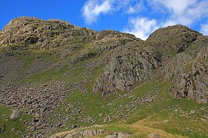
Ill Crag is a fell in Cumberland. By some counts it is the fourth-highest peak in England, though the great Alfred Wainwright deemed it no more than a subsidiary summit of Scafell Pike, albeit a fine one. It reaches a height of 3,068 feet.
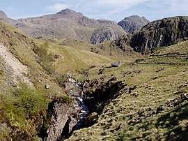
Ill Crag overlooks Eskdale and has splendid views across to Bowfell and Crinkle Crags. It forms part of the Scafell chain, and lies about less than a mile east of Scafell Pike. Broad Crag lies immediately to the west, between Ill Crag and the Pike.
Ascent
Ill Crag may be climbed on the climb up to Scafell Pike, by way of a path from Esk Hause, but it is commonly passed by without going to the actual summit, which is rocky, making progress slow. Ill Crag's summit is a few hundred yards to the south of the path from Esk Hause to Scafell Pike.Scafell and Ill Crag
Ill Crag is one of very few fells in the Lake District not to be given a separate chapter in Alfred Wainwright's celebrated guide books, though Wainwright does give it a page in the Scafell Pike chapter. It therefore does not qualify for the accolade of being a "Wainwright", though its height, exceeding 3,000 feet, qualifies it as a Furth Munro.
