Difference between revisions of "Frognall"
From Wikishire
(Created page with "{{Infobox town |name=Frognall |county=Lincolnshire |picture=Frognall village, Deeping St James, Lincs - geograph.org.uk - 95107.jpg |picture caption=Frognal |os grid ref=TF163...") |
(No difference)
|
Latest revision as of 21:19, 17 September 2020
| Frognall | |
| Lincolnshire | |
|---|---|
 Frognal | |
| Location | |
| Grid reference: | TF163102 |
| Location: | 52°40’37"N, 0°16’52"W |
| Data | |
| Post town: | Peterborough |
| Postcode: | PE6 |
| Local Government | |
| Council: | South Kesteven |
| Parliamentary constituency: |
South Holland and The Deepings |
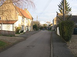
Frognall is a hamlet in Kesteven, the south-western part of Lincolnshire, sitting just north-east of Deeping St James, to which it is almost conjoined, and on the Spalding Road, the B1525, which becomes the A175 on its route northwards from The Deepings to Spalding.
The village public houses used to be The Goat and the Rose Inn. The Rose Inn closed down in 2013.
Outside links
| ("Wikimedia Commons" has material about Frognall) |
| Villages amongst 'The Deepings' in Lincolnshire and Northamptonshire |
|---|
|
Market Deeping • Deeping St James • Deeping St Nicholas • Deeping Gate • West Deeping |
|
See also: Stowgate • Frognall • Tongue End • Hop Pole |