Enard Bay

Enard Bay is a large, remote, tidal, coastal bay on the wild coast on Cromartyshire, where it meets Sutherland, on the Atlantic Ocean. The bay is ten miles north-west of Ullapool.
The mouth of the bay is about four and a half miles across running from the head of Rubha Mòr peninsula at Ru Coygach (Rubna Na CòiGeach) point to Kirkaig Point (Rubna Na Brèige) to the east.
Contents
Islands
The bay has a number of small islands, all within Cromartyshire:
- Eilean Mòr, on the north-east corner of the bay is the largest
- Fraochlan Island, less than quarter mile north, is the next
- Eilean Mòineseach east of Eilean Mòr
- Green Island is a small island located in the south-east of the bay.
Geography
In the coast of the bay, which travels almost on a north bearing downwards in diagonal from west to east has a number of settlements, the principal settlement is Lochinver, standing on its inlet to the north-west.
Enard Bay is bounded by Rhuba Mòr peninsula that runs from the northwest to the southeast in the south. To the south of Rhuba Mòr lie the Summer Isles.
On the west most south coast of Enard Bay, before the coast bears north-west is an inlet that forms into Enard Bay from Achnahaird Bay. At the head of Achnahaird Bay is a large white sandy beach. To the east of Achnahaird Bay is Garvie Bay, with a small sandy beach. Slightly Further east is the small Lag na Saille inlet. Polly bay is further to the east and north, close to the small rocky Green island. To the north of Polly Bay is a sea loch, Loch an Èisg Brachaidh located to the west of the cluster of the bay's main three islands.
A number of small fast flowing streams flow into the bay, the biggest amongst them is the River Polly, which flows into the Polly Bay inlet.
Two sea lochs, Loch Inver and much larger Loch Kirkaig are located to the north of the bay: Loch Kirkaig marks the boder of Sutherland.
Location
- Location: 58°5’45"N, 5°20’11"W
Pictures
- Images of Enard Bay and surrounding areas

From the Achiltibuie Road Looking across Garvie Bay, up to Enard Bay; the island is probably Eilan Mor, with Green Island towards the right.

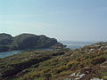
Rubh a Choin Rocky shoreline near the end of the peninsula between Garvie and Achnahaird bays. Suilven in the distance across Enard Bay.
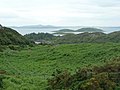
Bracken slopes down to Loch an Eisg-brachaidh The islands in Enard Bay beyond.
Loch Roe. Looking south over the entrance to Loch Roe with Enard Bay in the west. The headland in the distance is Rubha na Coigich.

Quinag from Achnahaird. A glint of sunshine picks out the ridge of Quinag across Enard Bay from Achnahaird.
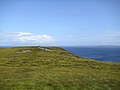
Cnoc Mor is a low ridge reaching 72m above sea level overlooking Achnahaird and Enard Bays. Looking in a northerly direction towards the coast near Stoer.


